Home | Category: History and Exploration
OUTSIDERS ARRIVE IN OCEANIA AND THE PACIFIC REGION

Terence E. Hays wrote in the “Encyclopedia of World Cultures”: “According to archaeological and other evidence, insular southeast Asian traders, slavers, trepang collectors, and bird of paradise plume hunters regularly sailed the waters and visited the coasts of western New Guinea and northern Australia for centuries before the first Europeans arrived there. |~|
“While their impact on the native peoples of the southwestern Pacific was doubtless significant, they left little in the way of written documentation of the cultures they encountered or of their dealings with the people. The historical record, and Oceania's emergence into the modem world, effectively began in the early sixteenth century. [Source:“Encyclopedia of World Cultures, Volume 2: Oceania,” edited by Terence E. Hays, 1991 |~|]
“Starting in the late thirteenth century, 'the East' (i.e., Asia and the islands of modern Malaysia and Indonesia) lured Europeans seeking spices and continuing the long search for Terra Australis Incognita, the 'southern continent" that many thought must exist to balance the known land masses of the northern hemisphere. In the late fifteenth century, land routes to the East were dominated by the Turks and no longer open to Europeans, so the latter looked to the sea. |~|
On the Asian side long-distance trade developed all along the coast from Mozambique to Japan. Trade, and therefore knowledge, extended to Indonesia but apparently not Australia. By at the latest 878 when there was a significant Islamic settlement in Canton much of this trade was controlled by Arabs or Muslims. In 219 B.C. Xu Fu sailed out into the Pacific searching for the elixir of immortality. Zheng He (1371–1433) was China's greatest explorer, mariner, and navigator. He reached Java in present-day Indonesia and traveled extensively in the Indian Ocean but as far as we know never went east of Java or reached what is now Oceania. [Source: Wikipedia
Japanese fishing boats, if blown out to sea, could be carried by the current all the way to North America. Japanese boats reached Acapulco in 1617, the Aleutians in 1782, Alaska in 1805, the mouth of the Columbia River in 1820, and Cape Flattery in 1833. Such trips may have taken place before Europeans were present in those areas to make detailed records of them.
Related Articles:
SPICES, TRADE AND THE SPICE ISLANDS factsanddetails.com ;
MAGELLAN AND THE FIRST VOYAGE AROUND THE WORLD ioa.factsanddetails.com ; DISCOVERY OF AUSTRALIA BY EUROPEANS ioa.factsanddetails.com
CAPTAIN JAMES COOK: HIS LIFE, CAREER, DEATH AND CONTRIBUTIONS ioa.factsanddetails.com ;
VOYAGES OF CAPTAIN JAMES COOK: SHIPS, CREW, MISSIONS, DISCOVERIES ioa.factsanddetails.com ;
CAPTAIN JAMES COOK IN NEW ZEALAND AND AUSTRALIA ioa.factsanddetails.com
CAPTAIN JAMES COOK IN THE PACIFIC: DESCRIPTIONS, EVENTS AND PLACES VISITED ioa.factsanddetails.com ;
FIRST EUROPEANS IN NEW ZEALAND ioa.factsanddetails.com
EUROPEANS IN THE PACIFIC IN THE 1800S: WHALERS, MISSIONARIES, COPRA AND FORCED LABOR ioa.factsanddetails.com ;
SPANISH-AMERICAN WAR AND ITS IMPACT ON THE NORTHERN PACIFIC factsanddetails.com
First Europeans in the Pacific
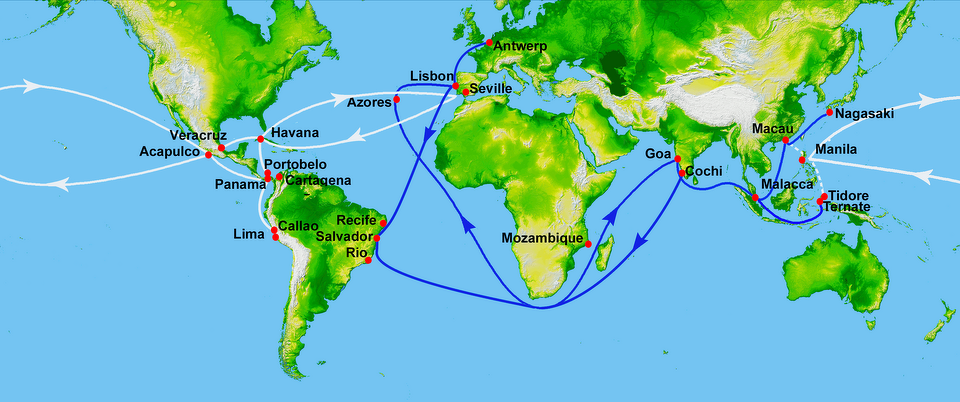
Portuguese trade routes (blue) and Spanish trade routes (white) in the 16th century
Eric Kjellgren wrote: Much of the early exploration of the Pacific was driven by two obsessions, the search for the best routes to the spice-rich islands of the Moluccas, in what is today eastern Indonesia, and the idea that a large, undiscovered continent lay somewhere in the southern Pacific. The first European explorers in the region were the Spanish and the Portuguese. By the late sixteenth century the Spanish, sailing westward from the Americas, had colonized the Philippines and the Mariana Islands and made brief visits to parts of the Caroline Islands, the Solomon Islands, and the Marquesas. Portuguese vessels, sailing east around the Cape of Good Hope to reach the Moluccas, explored eastern Indonesia and briefly encountered New Guinea. However, by 1600, the vast majority of the Pacific still lay unexplored by Europeans. [Source: Eric Kjellgren, “Oceania: Art of the Pacific Islands in The Metropolitan Museum of Art”, 2007]
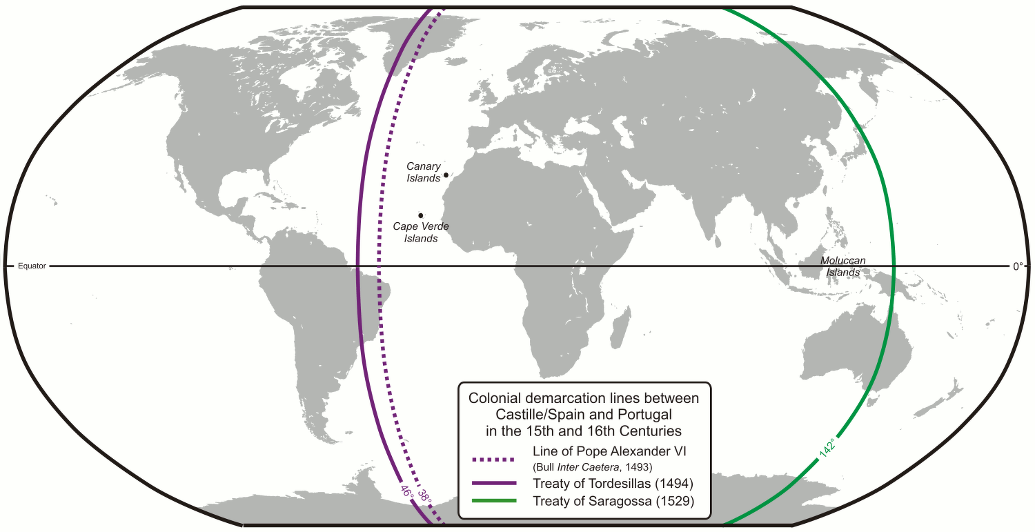
According to the “Encyclopedia of World Cultures”: “The Catholic church, through the Agreement of Tordesillas in 1491, divided the world (arrogantly) at a line 370 leagues west of the Cape Verde Islands; all to the west "belonged to" Spain, with Portugal's domain encompassing that half of the globe east of the line. Thus was set in motion Spain's voyages to the Western Hemisphere in search of spices and gold and its discovery of the New World in the process. [Source:“Encyclopedia of World Cultures, Volume 2: Oceania,” edited by Terence E. Hays, 1991 |~|]
“The first Spaniard to see the Pacific Ocean was Vasco Nuniez de Balboa, who viewed it looking south from what is now Panama and named it, accordingly, the 'South Sea." Throughout the sixteenth century Spanish explorers sailed southwest from Europe, rounding Cape Hom and scouring the Pacific seeking riches. The first of these was Ferdinand Magellan, who named the ocean "Pacific" because it seemed so calm compared to his stormy passage through what would later be called the Strait of Magellan (See Below).
The first contact of European navigators with the western edge of the Pacific Ocean was made by the Portuguese expeditions of António de Abreu and Francisco Serrão, via the Lesser Sunda Islands, to the Maluku Islands, in 1512,and with Jorge Álvares's expedition to southern China in 1513, both ordered by Afonso de Albuquerque from Malacca. Portuguese ships sailed to the southeast, around the Cape of Good Hope in Africa, and entered the Pacific from the west, landing at Yap in present-day Micronesia in the 1520s and New Guinea in the 1540s. [Source: Wikipedia]
Europeans knew that there was a vast ocean to the west, and the Chinese knew that there was one to the east. Learned Europeans thought that the world was round and that there was single large ocean between Europe and Asia. When Columbus sailed west in 1492 he thought he had reached Asia. In wasn’t until 1500, when Pedro Álvares Cabral, traveling to Asia via the Atlantic and the Indian oceans, reached Brazil, that the true extent of the Americas was realized. The Martin Waldseemüller map of 1507 was the first to show the Americas separating two distinct oceans. This guess was confirmed in 1513, when Balboa crossed Panama and found salt water. The Magellan expedition of 1519-22 proved that there was one continuous ocean from the Americas to Asia. The Diogo Ribeiro map of 1529 was the first to show the Pacific at about its proper size.
Spaniards and Portuguese explored the Pacific Ocean throughout the 16th century 'discovering" such island groups as the Solomon Islands (named in 1568 by Alvaro de Mendafia, who hoped he had found the fabled source of the gold of King Solomon), the Marshall Islands, the Ellice Islancs, the Marquesas Islands, and the northern Cook Islands. Their quest for material riches was largely unfulfilled, but they sought the glory of God as well as of kings, and Catholicism was established early, especially in Micronesia. |~|
Treaty of Tordesillas
The Treaty of Tordesillas divided the New World between Portugal and Spain. Signed in 1494, the agreement gave Spain all the land to the west of a meridian 370 degrees west of the Cape Verde Islands (off Africa), and the land to the east to Portugul. This agreement is why Brazil ended up being Portuguese and the rest of Latin America became a Spanish possession.
The Treaty of Tordesillas, was signed in Tordesillas, Spain, on June 7, 1494, two years after Columbus “discovered” America, and was ratified in Setúbal, Portugal. It divided the newly discovered lands outside Europe between the Portuguese Empire and the Spanish Empire (Crown of Castile). The line of demarcation was about halfway between the Cape Verde islands (already Portuguese) and the islands visited by Christopher Columbus on his first voyage (claimed for Castile and León), named in the treaty as Cipangu and Antillia (Cuba and Hispaniola). [Source: Wikipedia]
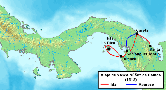
Balboa's route to the Pacific
The treaty modified an earlier division proposed by Pope Alexander VI. The other side of the world was divided by the Treaty of Zaragoza, signed on April 22, 1529, which specified the antimeridian to the line of demarcation specified in the Treaty of Tordesillas. The line dividing Spanish and Portuguese territory ran 370 leagues west of the Cape Verde islands on the Atlantic side (46̊longitude) and 134̊ longitude on the Asian side, but nobody knew exactly where that was. With the Treaty of Zaragosa in 1529, the Portuguese paid Emperor Charles V of Spain 350,000 gold ducats (a huge sum of money at that time) to gain possession sole of the Spice Islands. When chronometers were invented they showed that the land was in fact on the Portuguese side anyway. [Source: Merle Severy, National Geographic, November 1992]
Despite a considerable lack of information regarding the geography of the New World, Portugal and Spain largely respected the treaty. The other European powers, however, did not sign the treaty and generally ignored it, particularly those that became Protestant after the Reformation. Similarly, the indigenous peoples of the Americas did not acknowledge the treaty, and as the legal foundation for the discovery doctrine, it has been a source of ongoing tension regarding land ownership into modern times.
Balboa: “Discoverer” of the Pacific
Vasco Núñez de Balboa (1474-1517) was the first European to lay eyes on the Pacific Ocean from America in 1513 after his expedition crossed the Isthmus of Panama. He was an adventurer born into a poor family in southwestern Spain. He joined an expedition as a seaman in 1500 to the new World, where he worked as a planter in Santa Domingo for a short and time an then fled his creditors by stowing away on a ship to present-day Panama. [Source: Daniel Boorstin, "The Discoverers"]
Rodrigo de Bastidas discovered what is now Panama for Spain in 1501. On board of his ship was Balboa. After the crew was ravaged by disease and starvation he rose to command of the ship Balboa led a group of Spaniards ashore and took a village named Daríen — a name now applied to all of eastern Panama. Renamed Santa María la Antigua del Daríen, the village became the first successful Christian settlement in the New World.
Balboa claiming the Pacific
The Spanish settlers in Panama suffered terribly from starvation, tropical diseases and poison arrow Indian attacks. Balboa founded Santa María la Antigua del Darién, after moving the Spanish setters to place where the Indians didn't use poison arrows. He later made friends with the Comaco tribe by assisting them in a war against another tribe and marrying the daughter of a Comaco chief.
After watching a group of Spaniards squabble over a gift of 4,000 ounces gold the son of chief knocked over the scales in disgust and gave Balboa some key information that would lead to the discovery he is known for. According to contemporary chronicler Peter Martyr the young Indian said, "What is the matter, you Christian men, that you greatly esteem so little portion of gold more than your own quintessence....If you hunger for gold, be so insatiable...I will show you a region flowing with gold, where you may satisfy your ravenous appetites...When you are passing over these mountains...you shall see another sea, where they sail with ships as big as yours, using both sails and oars as you do, although the men be naked as we are."
Six years after discovering the Pacific, Balboa was arrested on trumped up charges and beheaded on the orders of the jealous Spanish governor Pedrárias Dávila (Pedro Arias Dávila), who replaced Balboa as governor and whose only claim to fame was that he married one of Isabella's ladies in waiting. Arriving with 20 ships and 1,500 men, he set about enslaving the natives which according to Balboa changed them into "fierce lions." After being falsely accused of conspiring to make himself the Emperor of South America, Balboa and four companions were beheaded in a public square and their bodies were fed to the vultures. Balboa's grave lies in some unknown location in the jungle somewhere.
Balboa Journey Across Panama
Balboa hacked through dense tropical rain forests for 25 days with 190 Spaniards and several hundred Indian guides and porters to reach the Pacific in 1513. The Indian guides and bearers," Martyr wrote "went ahead and opened the trail. they passed through inaccessible defiles inhabited by ferocious beasts, and they climbed steep mountains." Nineteenth-century expeditions that followed a similar route found the going very rough. A French explorers said he didn't see the sky through the dense jungle canopy for 11 days and German Botanical expedition lost every man.
A group of Quarequa Indians that tried to block Balboa's group with bow, arrows and two-handed wooden swords" were slaughtered by Balboa's men who dispensed with them "like butchers cutting up beef and mutton for market. Six hundred including the chief, were thus slain like brute beasts."
Describing the encounter, Martyr wrote: "Vasco discovered that the village of Quarequa was stained with the foulest vice. The king's brother and a number of other courtiers were dressed as women, and according to accounts of the neighbors shared the same passion. Vasco ordered forty of them to be torn to pieces like dogs. The Spaniards commonly used their in fighting against these people, and dogs threw themselves upon them as though they were wild boars or timid deer. The Spaniards found these animals as ready to share their dangers as did the people of Colophon or Bastabara, who trained cohorts of dogs for war; for the dogs were always in the lead and never shirked a fight."
Balboa “Discovers” the Pacific
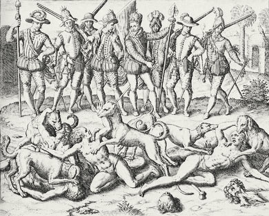
Balboa setting his dogs upon native practitioners of homosexuality (1594)
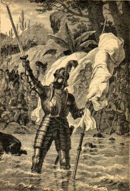
When Balboa the reached a peak with a view of the Pacific on September 25, 1513, he ascended first while his men had to wait behind. "Kneeling on the ground, he raised his hands to heaven and saluted the south sea; according to his account, he gave thanks to God and all the saints for having reserved this glory for him, an ordinary man, devoid a like of experience and authority." He then invited his men to join him and exclaimed, "Behold the much desired ocean! Behold! all ye men, who have shared such efforts behold the country of which the sons of Comogre and other natives have told us such wonders!"
After four day more days walking and being carried by Indians, Balboa reach the Pacific where he waded into the surf wearing his armor and raised the banner of Castile, formally taking possession of "all that sea and the countries bordering on it" for Spain. On the return journey Balboa was presented 240 perfect pearls, four pounds of lesser quality ones and 614 pesos in gold.
Balboa named the "other ocean" Mar del Sur (literally, "Sea of the South" or "South Sea") because of where he was located on the Panama Isthmus —on the south of the coast of the isthmus where the first is located to the south.
After Balboa's discovery, Panama became strategically important for the Spanish. All conquering expeditions on the Pacific were launched from the isthmus. His discovery also prompted the realization that there was still a great distance between the New World and Asia.
Magellan
Ferdinand Magellan was the leader of a group of sailors that the circled the globe in the early 16th century, an amazing feat that perhaps will not be equaled until a human being lands on Mars. Magellan himself did not complete the trip. Of the 300 or so men and five ships that left Portugal with Magellan only one ship made it back to its embarkation place and only 14 men made it back there alive.
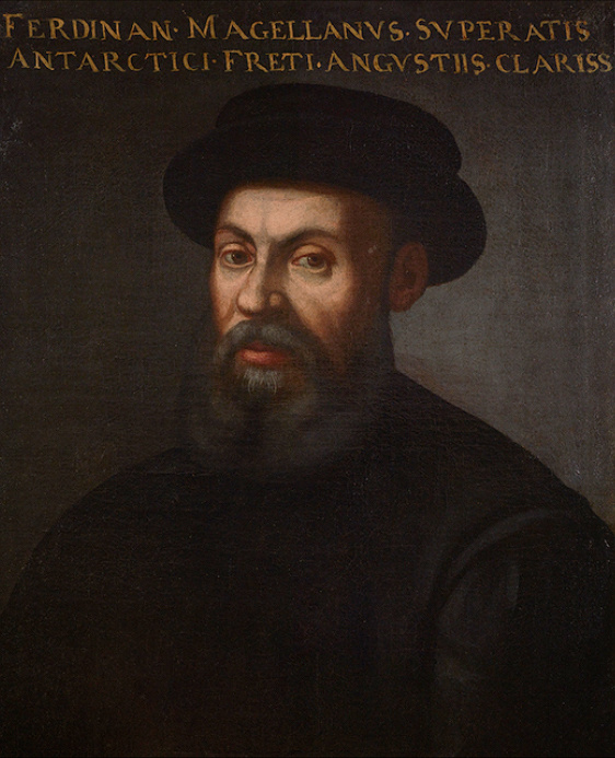
Magellan
Magellan sailed the Pacific East to West on a Spanish (Castilian) expedition of world circumnavigation starting in 1519. That year he sailed down the east coast of South America, found and sailed through the strait that bears his name. In November 1520, he entered the Pacific. Magellan then sailed north and caught the trade winds which carried him across the Pacific. In a vivid illustration of the emptiness of the Pacific, Magellan sailed across the entire ocean before touching land in the Mariana Islands of western Micronesia in 1521. After Magellan was killed in the what is now the Philippines, one surviving ship went west across the Indian Ocean and the other went north in the hope of finding the westerlies and reaching Mexico. The Pacific was often called the Sea of Magellan in his honor until the eighteenth century.
"No other had so much natural wit, boldness, or knowledge," is how one man described Magellan. W said he was an "able and ruthless" Portugese soldier-adventurer-seaman with battle-lame leg. "Magellan's feat," wrote historian Daniel Boorstin, "by any measure — moral, intellectual, or physical — would excel even that of Gama or Columbus or Vespucci. he would face rougher seas, negotiate more treacherous passages and find his way across a broader ocean.”
Spanish in the Pacific Ocean
Magellan sailed the Pacific for Spain (Castile) . After crossing the Pacific Ocean one surviving ship returned west across the Indian Ocean and the other went north in the hope of finding the westerlies and reaching Mexico. Unable to find the right winds, it was forced to return to the East Indies. . In 1565 (44 years later), Andrés de Urdaneta found a wind system that would reliably blow a ship eastward back to the Americas.
In 1517-18, two Spanish ships were built on the Pacific coast. In 1522, Pascual de Andagoya sailed the coast as far as Ecuador. In 1526, six years after Magellan, one of the ships of an expedition led by García Jofre de Loaísa [Loaísa expedition sailed through the Strait of Magellan and followed the coast north to Mexico. In 1532, Francisco Pizarro conquered Peru. A regular trade developed that carried Peruvian silver up the coast to Panama where it was carried overland to the Caribbean and part to Spain. Spanish settlement extended as far south as central Chile. In 1557-8, Juan Fernández Ladrillero discovered the Juan Fernandez islands and explored the Chilean coast down to the Strait of Magellan.
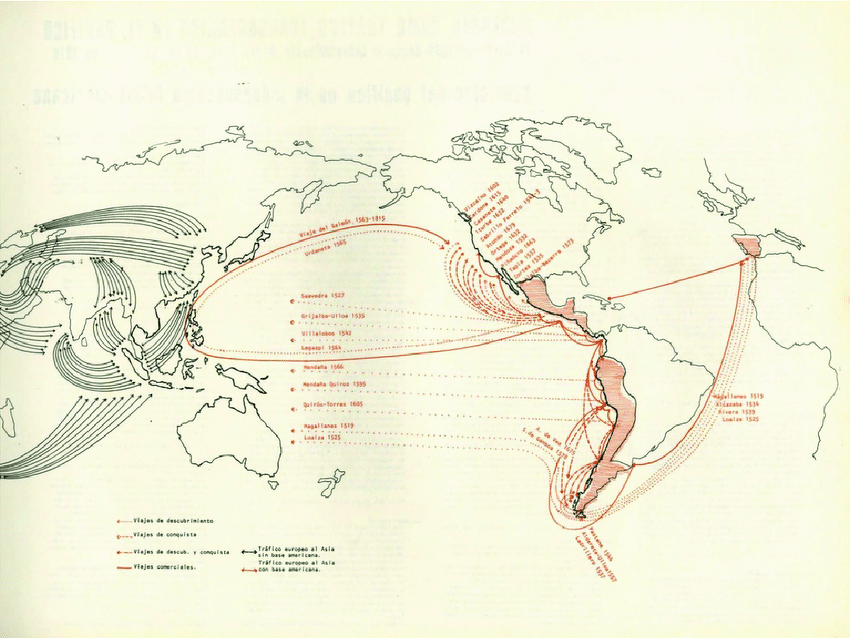
From 1565 to 1815, a Spanish transpacific route known as the Manila galleons regularly crossed from Mexico to the Philippines and back, exchanging Mexican silver for spices and porcelain.. Spanish power dominated the American side of the Pacific Ocean, controlling an area stretching thousands of kilometers from Mexico to Chile. The vast central Pacific was visited only by the Manila galleons and an occasional explorer. Until the time of Captain James Cook the Manila Galleons were the only large ships to regularly cross the Pacific. The route was purely commercial and there was no exploration of the areas to the north and south. In 1668, the Spanish founded a colony on Guam as a resting place for west-bound galleons. For a long time this was the only non-coastal European settlement in the Pacific.
The south Pacific was first crossed by the Spanish, who discovered many islands including Tuvalu, the Marquesas, the Cook Islands, the Solomon Islands, and the Admiralty Islands, and later the Pitcairn and Vanuatu archipelagos. Several Spanish expeditions were sent from South America across the Pacific Ocean in the 16th and early 17th centuries. They all used the southern trade winds. In 1567/68, Álvaro de Mendaña de Neira sailed from Peru to the Solomon Islands. In 1595, he tried again and reached the Santa Cruz Islands (eastern Solomons toward Fiji). He died there and the survivors reached the Philippines. In 1606, Pedro Fernandes de Queirós reached Vanuatu south of the Solomons. He continued exploring and eventually sailed back to Mexico. One of his separated ships under Luis Vaz de Torres sailed west and discovered the strait that bears his name sighting the northern tip of Australia. Other Spanish expeditions discovered Tuvalu, the Marquesas, the Cook Islands, the Admiralty Islands and the Pitcairn.
SPANISH GALLEON TRADE BETWEEN THE PHILIPPINES AND MEXICO factsanddetails.com
Major Pacific Islands Discovered the Spanish
1521: Unfortunate Islands by Ferdinand Magellan (a Portuguese sailing for Spain), two atolls
1521: Thieves' Islands (Mariana Islands) also by the Portuguese Ferdinand Magellan, from Spain.
1525: Caroline Islands by Diogo da Rocha and Gomes de Sequeira, from the Portuguese East Indies (Moluccas).
1526: Islands of the Painted People (Marshall Islands) by Alonso de Salazar of the Loaísa expedition
1543: Bonin Islands by Bernardo de la Torre from Mexico [Source: Wikipedia
1568: Solomon Islands, the Ellice Islands (Tuvalu) and Wake Island by Álvaro de Mendaña de Neira from South America
1574: Juan Fernández Islands by Juan Fernández.
1595: Marquesas Islands and the Santa Cruz Islands by Álvaro de Mendaña de Neira from South America
1606: Tuamotu Archipelago, Butaritari and Makin (Gilbert Islands), the New Hebrides (Vanuatu) by Pedro Fernandes de Queirós from South America
1606: the Torres Strait between Australia and New Guinea by Luis Viez de Torres
Portuguese in the Pacific Ocean
On the Asian side of the Pacific Ocean the Portuguese and later the Dutch built a regular trade from the East Indies to Japan. The Portuguese reached India in 1498, conquered Malacca in 1511 and in 1512 António de Abreu and Francisco Serrão reached the Spice Islands. In May 1513 Jorge Álvares reached southern China and in the same year Balboa crossed Panama. [Source: Wikipedia]
In 1525 Diogo da Rocha and Gomes de Sequeira reached the Caroline Islands, and Jorge de Menezes in 1526-27 landed on the Islands of Don Jorge de Menezes, in the northwest coast of New Guinea (now part of Indonesia), and named the region Ilhas dos Papuas and is thus credited with the European discovery of Papua.
In 1542 Fernão Mendes Pinto reached Japan. From about 1543 until 1614, the Portuguese monopolize the trade between China and Japan, through the nanban trade. In 1589, João da Gama reached Hokkaido and possibly sighted the Kuril islands, crossing the Pacific further north of the routes usually taken until then. The land that he eventually discovered northeast of Japan, has since become a matter of legend and controversy.
Dutch in the Pacific Ocean
On the Asian side of the Pacific Ocean the Dutch defeated and outmaneuvered the Portuguese and took control of the trade routes from the East Indies and Japan to Europe. One hundred years after the Spanish and Portuguese the Dutch Republic began its remarkable expansion. The Dutch reached the East Indies in 1596, the Spice Islands in 1602 and in 1619 founded Batavia (present-day Jakarta) in what is now Indonesia. In 1599, the first Dutch ships passed through the Strait of Magellan. In 1600 this fleet of Dutch ships reached Japan from. Will Adams, the first Englishman to reach Japan, was on board. Olivier van Noort followed and became the first Dutch circumnavigator. In 1722, the Dutchman Jacob Roggeveen sailed from Cape Horn to Batavia and discovered Easter Island and Samoa. [Source: Wikipedia]
Following the defeat of the Spanish Armada in 1588 and other political changes in Europe, the hegemony of the Spanish and Portuguese in the Pacific was drastically reduced. Eric Kjellgren wrote: In the early seventeenth century the Dutch seized control of the Moluccas from the Portuguese and, as a result of both intentional expeditions and chance encounters by spice traders blown off course, began to chart the northern and western coasts of Australia. The Dutch exploration of the Pacific culminated with the voyage of Abel Janszoon Tasman (1603?-?1659) from 1642 to 1643. Sailing south of Australia, Tasman encountered Tasmania and Aotearoa. He later visited Tonga and Fiji, as well as New Ireland and other parts of Island Melanesia. Tasman 's journal includes an illustration of three New Ireland men in a canoe, whose openwork prow and stern ornaments, though somewhat fancifully rendered, are similar to historical examples. This illustration is among the earliest images of Oceanic art to be seen in the West. [Source: Eric Kjellgren, “Oceania: Art of the Pacific Islands in The Metropolitan Museum of Art”, 2007]
Terence E. Hays wrote in the “Encyclopedia of World Cultures”: “The Pacific in the seventeenth century was largely the province of the Dutch. Their primary motivation was business, particularly in spices, and in 1602 they established the Dutch United East India Company. From their bases in the 'Dutch East Indies" (Malaysia and Indonesia), Dutch ships probed to the east, with Willem Schouten and Jacob le Maire sailing along the northern coast of New Guinea and eastward to Futuna and Tonga in 1616, and Abel Tasman exploring much of the southern coast of Australia as well as Tasmania, which now bears his name, and as far east as Fiji in 1643. Little ofwhat the Dutch found was made public due to their concern with secrecy for purposes of trade monopoly, but sketchy reports trickled back to Europe and inspired such fanciful works of literature as Gulliver's Travels. [Source:“Encyclopedia of World Cultures, Volume 2: Oceania,” edited by Terence E. Hays, 1991 |~|]
The Dutch had little success in China but established themselves at Hirado, Nagasaki in 1609 and monopolized the Japan trade from 1639. In 1639 Matthijs Quast and Abel Tasman searched the empty ocean east of Japan looking for two islands called 'Rica de Oro' and 'Rica de Plata'. In 1643 Maarten Gerritsz Vries reached and charted Sakhalin and the Kuril Islands. In 1653 Hendrick Hamel was shipwrecked in Korea. At about this time the Russians reached the Pacific overland via Siberia. It is significant that the Russian and Dutch trades were never linked since Siberian furs might easily have been exported to China at great profit.
Major Pacific Islands Discovered the Dutch
1616: Friendly Islands (Niua Islands of Tonga) and the Bismarck Archipelago by Willem Schouten from Cape Horn.
1642: Van Diemen's Land (Tasmania), New Zealand, the southern Friendly Islands (Tonga), and the Cannibal Isles (Fiji) by Abel Tasman
1722: Easter Island and the Navigator Islands (Samoa) by Jacob Roggeveen from Cape Horn
1741: Aleutian Islands by Vitus Bering and Alexei Chirikov from Russia [Source: Wikipedia]
British in the Pacific Ocean
Eric Kjellgren wrote: In the eighteenth century the exploration of Oceania was dominated by Britain and France. Starting in the mid-1700s, the rival nations began to send out scientific expeditions to explore and chart the islands of the Pacific. By far the most wide-ranging of these explorers was the British navigator Captain James Cook (1728-1779), who made three separate voyages to the Pacific. Cook's voyages witnessed the first encounter between Europeans and many Pacific peoples, and Cook and other expedition members brought the first substantial collections of Oceanic objects back to Europe. The sketches and paintings made by the artists on Cook's expeditions many of which were later engraved and published in the widely popular accounts of his voyages, offered many Europeans their first glimpses of the peoples and arts of Oceania. [Source: Eric Kjellgren, “Oceania: Art of the Pacific Islands in The Metropolitan Museum of Art”, 2007]
Map of nautical routes in the Pacific Ocean during the 16th and 17th century
The voyages of Captain Cook in the Pacific
First voyage (1768–1771)
Second voyage (1772–1775)
Third voyage (1776–1779)
Major Pacific Islands Discovered the British
1765: Tokelau and Nikunau by John Byron
1767: Tahiti by Samuel Wallis
1774: New Caledonia and Norfolk Island by James Cook
1777: Christmas Island (now Kiribati) by James Cook
1778: Sandwich Islands (Hawaii) by James Cook
1788: Gilbert Islands (now Kiribati) by Thomas Gilbert and John Marshall.
1791: Chatham Islands by William R. Broughton [Source: Wikipedia]
Related Articles: CAPTAIN JAMES COOK: HIS LIFE, CAREER, DEATH AND CONTRIBUTIONS ioa.factsanddetails.com ; VOYAGES OF CAPTAIN JAMES COOK: SHIPS, CREW, MISSIONS, DISCOVERIES ioa.factsanddetails.com ; CAPTAIN JAMES COOK IN NEW ZEALAND AND AUSTRALIA ioa.factsanddetails.com CAPTAIN JAMES COOK IN THE PACIFIC: DESCRIPTIONS, EVENTS AND PLACES VISITED ioa.factsanddetails.com ; FIRST EUROPEAN IN NEW ZEALAND: EXPLORERS, SETTLERS AND THEIR IMPACT ON THE MAORI ioa.factsanddetails.com
Sir Francis Drake
Although he was active about a hundred years after Columbus and he didn't really discover anything, Drake was one of the most important navigators of the age of exploration and conquest. He was first captain to sail his own ship around the world but more importantly he almost single-handedly tipped the global balance of power from Spain to England with his dramatic raids on Spanish ships and ports and his courageous leadership in battles between the two European powers. [Source: Alan Villiers, National Geographic, February; Simon Winchester, Smithsonian]
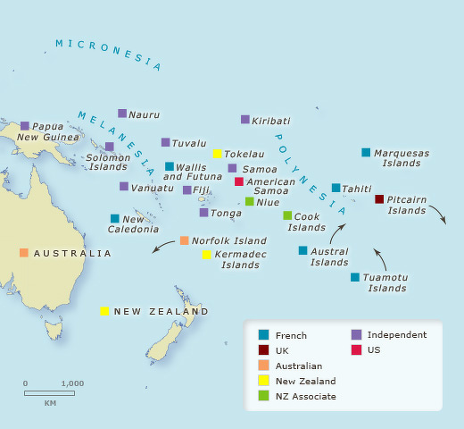
Control of the Pacific Islands in 1901
Before Drake, Britain was a relatively small inward country that battled France from time to time but had relatively little global influence compared to Spain and Portugal, the great maritime powers. After Drake, England was one of the most powerful nation in the earth. An argument can be made that the British empire began with Drake.
There were no reports of Drake’s voyage for more than a decade after it was completed. Richart Hakluyt's “Voiyages and Discoveries of the English Nation made by sea or over land to the most remote and farthest distant quarters of earth”, published in 1589 made no mention of the Drake's historic circumnavigation. Part of the reason for this was that the information was marked as "top-secret" and was locked away because it might be useful to foreign competitors.
Most of what we know of Drake's voyage comes from “The World Encompassed”, an account of the voyage made by Drake's nephew published in 1628. Drake's personal journal, which was given to Queen Elizabeth, has been lost to history. Perhaps it was destroyed on purpose because it had damaging accounts of piracy or geographical information that could be useful to England's enemies.
Book: 1990 biography by John Sugden; Sir Julian Corbett's famous hagiography published in the 1890s.
Drake's Round the World Voyage
Drake set sail from England on December 13, 1577 with five seaworthy ships led by the “Pelican”. The ship was renamed the “Golden Hind” in mid-voyage presumably to curry favor with one of Queen Elizabeth's backers (on his coat of arms was a hind, or deer). The “Golden Hind “was a three-masted ship about the same size as the Mayflower. No one is exactly sure of the “Golden Hind”'s measurements but similar ships of that era were 70 feet long, with a 20-foot beam and a 13-foot draft and 18 cannons.
Drake traveled south to the Cape Verde Island and then across the South Atlantic to present-day Brazil and Argentina. After passing through the Straits of Magellan in late 1578, the “Golden Hind “followed the South and North American coast, and set sail from California in June 1579 for 68 day journey across the Pacific to Palau and Indonesia. After traversing the Indian Ocean Drake rounded the Cape of Good Hope in June 1580 and returned to England on September 16, 1580.
After passing through the Strait of Magellan, Drake sailed north raiding Spanish ships during his successful circumnavigation of the globe. In June 1579, his ship briefly made first landfall at South Cove, Cape Arago, just south of Coos Bay, Oregon, and then sailed south while searching for a suitable harbor to repair his ship. Drake and his crew found a protected cove when they landed on the Pacific coast of what is now Northern California. While ashore, he claimed the area for Queen Elizabeth I as Nova Albion or New Albion. In 1580, Pedro Sarmiento de Gamboa, who was hunting for Drake, was the first to sail from the Strait to Europe. In 1587, Thomas Cavendish followed Drake, captured a Manila galleon and returned via the Pacific and the Indian Ocean. [Source: Wikipedia
Only one of the five ships, the “Golden Hinde”, made it around the world (one sank, two were destroyed and an another returned across the Atlantic). Unlike Magellan, who was killed in the Philippines, Drake returned with his ship, making him the first captain to circumnavigate the globe.
Drake didn't inform his crew of the true nature of the mission. Sailors were told the ships were bound for Alexandria, Egypt to trade with Turkish merchants and they were only going to be gone for a short while. Officers were given only enough information to get to the next port. Some of the seaman may have thought the ships were on a voyage to find the mythical southern continent “Terra Ausrtalis Incognita” or discover a northwest passage between the Atlantic and the Pacific.
The real mission of Drake's voyage appears to have been to plunder Spanish ports and ships. The expedition was so secret that a report of it didn’t turn up until a decade after the voyage was completed. It is not clear whether Drake intended to sail around the world. His official orders were to "returne...the same way...homewardes, as he went owt.
Discovery of Australia
Australia is remarkable for the number of explorers who missed it. Some think that the Portuguese reached Australia before 1600 but these theories are difficult to prove. The 1567–1606 Spanish voyages from South America stopped at islands to the east before reaching Australia. [Source: Wikipedia]
The first European to definitely see Australia was Willem Janszoon who in February 1606 reached the Cape York Peninsula and thought it was part of New Guinea. Also in 1606 (June to October) Luis Váez de Torres of the Quiros expedition from South America followed the south coast of New Guinea and passed through the Torres Strait without recognizing Australia. His voyage, and therefore the separation between Australia and New Guinea, was not generally known until 1765. From about 1611, the standard Dutch route to the East Indies was to follow the roaring forties as far east as possible and then turn sharply north to Batavia. Since it was difficult to know longitude some ships would reach the west coast or be wrecked on it.
In 1616, Dirk Hartog bumped into the west coast and did some exploring. Frederick de Houtman did the same in 1619. In 1623 Jan Carstenszoon followed the south coast of New Guinea, missed Torres Strait and went along the north coast of Australia.
In 1643, Abel Tasman left Mauritius, missed Australia, found Tasmania, continued east and found New Zealand, missed the strait between the north and south islands, turned northwest, missed Australia again and sailed along the north coast of New Guinea. In 1644, he followed the south coast of New Guinea, missed the Torres Strait, turned south and mapped the north coast of Australia. In 1688, the English buccaneer William Dampier beached a ship on the northwest coast. In 1696, Willem de Vlamingh explored the southwest coast. In 1699, Dampier was sent to find the east coast of Australia. He sailed along the west coast, went north to Timor, followed the north coast of New Guinea to the Bismarck Archipelago and abandoned his search because his ship had become rotten. Until Captain Cook the east coast was completely unknown and New Zealand had only been seen once.
See Separate Article: DISCOVERY OF AUSTRALIA BY EUROPEANS ioa.factsanddetails.com
Louis-Antoine de Bougainville
Louis-Antoine, Comte de Bougainville (1729–1811) was a French admiral and explorer. A contemporary of the British explorer James Cook, he is arguably France’s most famous explorer. His expeditions included a circumnavigation of the globe in a scientific expedition in 1763, the first recorded settlement on the Falkland Islands, and voyages into the Pacific Ocean. Bougainville Island of Papua New Guinea as well as the Bougainvillea flower are named after him. [Source: Wikipedia]
The son of a notary, Bougainville was born in Paris. He studied law, but abandoned the profession and entered the French Army as a musketeer in 1753. He took part in the Seven Years' War in North America and the American Revolutionary War against Britain.
In 1766 Bougainville received from Louis XV permission to circumnavigate the globe. He became the 14th navigator, and the first Frenchman to do so). Completion of his mission bolstered the prestige of France following its defeats during the Seven Years' War. This was the first expedition to circumnavigate the globe with professional naturalists and geographers aboard.
Bougainville’s Round-the-World Voyage
Bougainville left Nantes in November 1766 with two ships: the Boudeuse and the Étoile. This was a large expedition, with a crew of 214 aboard Boudeuse and 116 aboard Étoile. Included in the party was the botanist Philibert Commerçon (who named the flower Bougainvillea) and his valet. Commerson's valet was later revealed to be a woman Jeanne Barret (also Baré or Baret); she would become the first woman known to circumnavigate the globe. One of his missions was to find Terra Australis — the mythical Southern Continent,
In 1768,Bougainville visited Tahiti and claimed it for France. After his expedition left Tahiti. he sailed westward to southern Samoa and the New Hebrides, then on sighting Espiritu Santo turned west still looking for the Terra Australis. In June he almost ran into heavy breakers and had to change course to the north and east almost found the Great Barrier Reef. He sailed through the present-day Solomon Islands but, because of hostile reception avoided landing there. He named Bougainville Island in what is now Papua New Guinea for himself. After the expedition was attacked in New Ireland to the Dutch East Indies. In Batavia (Jakarta) he received news that Wallis had beat him to Tahiti.
Bougainville completed his circumnavigation and made it back to France in March 1769. The expedition had lost only seven of its 340 crew, an extremely low level of casualties — the result it is said, of the enlightened management of the expedition by Bougainville.
In 1771, Bougainville published his travel log from the expedition “Voyage autour du monde and A Voyage Around the World)”. The book describes the geography, biology and anthropology of Argentina (then a Spanish colony), Patagonia, Tahiti and Indonesia (then a Dutch colony). The book was a sensation, especially the description of Tahitian society.
Image Sources: Wikimedia Commons
Text Sources: “Encyclopedia of World Cultures, Volume 2: Oceania,” edited by Terence E. Hays, 1991, Wikipedia, New York Times, Washington Post, Los Angeles Times, Times of London, Lonely Planet Guides, Library of Congress, The Guardian, National Geographic, Smithsonian magazine, The New Yorker, Reuters, Associated Press, AFP, BBC, CNN, and various books, websites and other publications.
Last updated October 2025