Home | Category: Oceans and Sea Life / Coastal Areas / Island and Island Group Territories
ISLANDS
 Ocean islands are basically divided into three types: 1) "low" coral and sand islands; 2) "high" islands (usually exposed peaks and ridge-tops of submerged mountains and volcanos); and 3) parts of the continental shelf. Some continental islands were mountains and hills along the coast during last Ice Age when ocean levels were lower.
Low islands or cays were formed on coral shoals from reef sediments. Atoll islands are low islands (See Below). Seabird dropping fertilize the soils of some of these islands, which allow scrubby forest to take root. Others are battered regularly by storms and are little more than shifting piles of sand. Some patches of sand are so low they disappear during low tide and lose their status as islands.
High islands generally have better soil and a better supply of water than low islands. Low islands support only a few species of plant because there little topsoil and this soil has a high salt content. Although they often have no visible water sources they often are positioned over water lenses that trap rain water and can provide fresh water through wells.
Mangrove swamps are found along the shores of islands in areas where the water is calm. Beaches and rocky shorelines are found in areas exposed to the open ocean. Barrier reef surround many ocean islands. The water between the reef and the shore is often relatively shallow and gets hot in the afternoon. Near some islands upwelling from deep sea trenches provide nutrients for abundant marine life.
Related Articles:
OCEANS: THEIR HISTORY, WATER, LAYERS AND DEPTH ioa.factsanddetails.com
SEAS AND OCEANS: DEFINITIONS, FEATURES AND THE MAIN ONES ioa.factsanddetails.com
PHYSICAL FEATURES OF THE OCEAN FLOOR: TRENCHES, VENTS, MOUNTAINS ioa.factsanddetails.com
LARGE WAVES: ROUGE WAVES, METEOTSUNAMIS AND THE BIGGEST WAVES EVER ioa.factsanddetails.com
OCEAN CURRENTS ioa.factsanddetails.com
SURVIVORS AT SEA: ADRIFT FOR MONTHS, ALONE IN A RAFT AND 480 METERS UNDERWATER ioa.factsanddetails.com ; COASTAL AREAS: PROCESSES, LANDFORMS AND LIFE ioa.factsanddetails.com
BEACHES: SAND, SURF AND FOAM ioa.factsanddetails.com ;
BEACH SAFETY, DANGERS AND HAZARDS ioa.factsanddetails.com
TIDAL POOLS, INTERTIDAL ZONE AND LIFE FOUND THERE ioa.factsanddetails.com
SEAGRASS— FEATURES, ECOSYSTEMS AND THE WORLD’S OLDEST AND BIGGEST PLANTS ioa.factsanddetails.com
WETLANDS, MARSHES AND ESTUARIES ioa.factsanddetails.com
MANGROVES: CHARACTERISTICS, CONSERVATION AND ROLE IN CLIMATE CHANGE ioa.factsanddetails.com
Websites and Resources: National Oceanic and Atmospheric Administration (NOAA) noaa.gov; “Introduction to Physical Oceanography” by Robert Stewart , Texas A&M University, 2008 uv.es/hegigui/Kasper ; Woods Hole Oceanographic Institute whoi.edu ; Cousteau Society cousteau.org ; Monterey Bay Aquarium montereybayaquarium.org
RECOMMENDED BOOKS:
“The Unnatural History of the Sea” by Callum Roberts (Island Press (2009). Roberts is a professor of marine conservation at the University of York in England Amazon.com
“Ocean: The World's Last Wilderness Revealed” by Robert Dinwiddie , Philip Eales, et al. (2008) Amazon.com
“Into the Great Wide Ocean: Life in the Least Known Habitat on Earth” by Sönke Johnsen (2024) Amazon.com
“An Introduction to the World's Oceans” by Keith A. Sverdrup (1984) Amazon.com
“The Sea Around Us” by Rachel Carson, an influential work that highlights the importance of ocean conservation (1950) Amazon.com
“The Life & Love of the Sea” by Lewis Blackwell Amazon.com
“Song for the Blue Ocean” by Carl Safina (1998) Amazon.com
“Blue Hope: Exploring and Caring for Earth's Magnificent Ocean” by Sylvia Earle (2014) Amazon.com
“National Geographic Ocean: A Global Odyssey” by Sylvia Earle (2021) Amazon.com
“Deep: Freediving, Renegade Science, and What the Ocean Tells Us About Ourselves” by James Nestor, investigates the ocean and human physiology through freediving. Amazon.com
“The Log from the Sea of Cortez” by John Steinbeck (Penguin Classics) (1951) Amazon.com
“The Ocean Book: The Stories, Science, and History of Oceans” by DK (2025) Amazon.com
“Ocean Art: From the Shore to the Deep” by Helen Scales (2025) Amazon.com
Reef Islands

Mataiva Atoll, Tuamotu Archipelago, South Pacific
Reef islands are built through a process of coral formation known as accretion. Rubble of reef rock broken off from the reef by heavy storms such as hurricanes and typhoons create reef-top shoals. Due to the normal action of waves and ocean currents other materials begin to gradually accumulate. Beaches develop around these shallows with wind heaping up lighter material into rises, hills and dunes. The material being almost entirely made of calcium carbonate readily dissolves in rainwater and the dissolved lime is then redeposited around the loose materials, cementing it together. After a while the islands are colonized by coconuts and others plants brought in by floating seeds or flotsam and birds and insects that have deposit seeds in their feces.
The most-massive animal-made structures on earth, reefs are giant colonies, often resembling huge undersea rock outcrops, made of a layer of millions of living polyps lying in top of a supporting structure of trillions of dead coral skeletons. Reefs vary in size from a human fist to a small country. Hard stony corals, resembling brown and green colored rocks, are the major reef builders.
The main types of reef are: 1) barrier reefs, coral breakwaters rising from the edge of a continental shelf: 2) platform reefs, irregular circles and crescents of corals that grow in calm waters; 3) patch reefs, smaller, scattered formations that grow in shallow water; and 4) fringing reefs, which grow outward from the shore.
Atolls
An atoll is a group of islands that encircle a central lagoon. Classic atolls develop on the top guyots, flat-topped volcanic sea mounts, that rise above the sea and then erode and sink under the weight of the coral reefs that grow on their slopes.
A classic atolls begins as a reef that forms around a high island. As the island sinks under the weight of the coral reef, the coral reef grows upwards causing the island to sink even more. This process eventually forms a barrier reef which is separated from the shore by a shallow lagoon. Eventually the original mountain becomes completely submerged and islands are created from the coral and sand deposits that accumulate on the highest points of the reef. These islands often roughly follow the contour of the original mountain top. The atoll-making process takes hundreds of thousands or millions of years.
A classic atoll is oval shaped. Most atolls have a lagoon sheltered by the barrier reef and islands with a small break or channel that allows boats to enter the lagoon. Sea grass beds are found along with reefs in the protected waters of the lagoons. The lagoons of some atolls are so large that it is difficult to see all the islands from any particular point. Their atoll shape is only visible from the air. Mountainous islands tend to be younger than developed atolls.
Atoll islands are usually narrow, long, flat and sandy. Most are uninhabited and many go unvisited for months or even years at a time. Around the sheltered sides of islands fringing reefs or mangroves often located right at the shore. The top of the reef is typically fairly shallow. Below the sea floor may be 10 meters deep or so. In some places there are walls or drop offs, where the reef suddenly gives way to deep ocean water. These walls are often teeming with life and are popular with scuba divers.
Darwin and Atolls

Atoll forming In addition to developing a theory of evolution, Charles Darwin was the first man to suggest that atolls were built by coral reefs left on the remnants of volcanos and mountains uplifted by the forces of the earth. He based this observation partly on the fact he noticed fossils of sea shells at 14,000 feet in the Andes.
Darwin’s first scientific book was “The Structure and Distribution of Coral Reefs”. In it he described three types of coral reefs: barrier reefs, fringing reefs and atolls. In his time coral polyps hadn’t yet been discovered and for him the creatures that made up the reef were “coral insects.” His great insights about atolls and reefs was made by combining his observations of coral with his understanding of geology, which was partly shaped by his first hand experience with an earthquake and a volcanic eruption in Chile in 1835 and observation of oceanic volcanoes in the Galapagos Island and the reef-fringed volcanic island of Moorea in Tahiti.
Before Darwin mariners had noted the unusual structure of atolls and proposed several explanations. Among them was the idea that a huge mass of fish got together and carried sand in their mouths and deposited it to make an atoll. Some speculated there was a connection between coral and the islands but more viewed the islands as objects akin to wasps nests and beehives rather than features that were geological in origin. Darwin was clever enough to realize that volcanoes provide the initial structure for reefs to build on and that the growth of coral occurred as the land below them subsided.
Darwin wrote: “We must look at a Lagoon island as a monument raised by myriads of tiny architects, to mark the spot where a former land lies buried in the depths of the ocean...The naturalist will feel his astonishment more deeply after having examined the soft and almost gelatinous bodies of these apparently insignificant creatures, and when he knows that the solid reef increases only on the outer edge, which day and night is lashed by the breakers of an ocean never at rest.”
The only coral islands that Darwin is believed to have set foot on were the Cocos, or Keeling, Islands in the northeast Indian Ocean, where among other things he noted that delicate branch-like corals thrived in the lagoons while hardier, boulder-like brain corals thrived in the rougher seas on the open ocean side of the islands.
Hot Spots
In geology, hotspots (or hot spots) are places with volcanic activity thought to be fed by underlying mantle that is unusually hot compared with the surrounding mantle (the layer of the Earth between the core at the center and the crust near the surface). A hotspot's position on the Earth's surface stays remains stationary, independent of tectonic plate movements over them. Some hotspots create chains of volcanoes as the plates move above them. There are two hypotheses on hot spot origins: 1) they are caused by mantle plumes that rise as thermal diapirs from the core–mantle boundary; 2) they are not caused anomalously-hot mantle sources but rather by crust above the mantle that is unusually weak or thin. [Source: Wikipedia]
The Earth’s outer crust is made up of a series of tectonic plates that move over the surface of the planet. In areas where the plates come together, sometimes volcanoes will form. Volcanoes can also form in the middle of a plate, where magma rises upward until it erupts on the seafloor — a “hot spot.”
According to National Geographic: A hot spot is fed by heat in the mantle rises through the process of convection. This heat facilitates the melting of rock at the base of the lithosphere, where the brittle, upper portion of the mantle meets Earth’s crust. The melted rock, known as magma, often pushes through cracks in the crust to form volcanoes. Hot spot volcanism is unique because it does not occur at the boundaries of Earth’s tectonic plates, where all other volcanism occurs. Instead it occurs at abnormally hot centers known as mantle plumes. Scientific models depict these plumes of molten rock almost like a lava lamp, with a rising bulbous head fed by a long, narrow tail that originates in the mantle. As the plume head reaches the lithosphere, it spreads into a mushroom shape that reaches roughly 500 to 1,000 kilometers (310 to 621 miles) in diameter. These features are called diapirs. [Source: National Geographic]
Scientists have different theories about where hot spots form. The dominant theory, framed by Canadian geophysicist J. Tuzo Wilson in 1963, states that hot spot volcanoes are created by exceptionally hot areas fixed deep below Earth’s mantle. More recent scientific studies suggest that these hot spots may be found at more shallow depths in Earth’s mantle and may migrate slowly over geologic time rather than stay fixed in the same spot. A volcano above a hot spot does not erupt forever. Attached to the tectonic plate below, the volcano moves and is eventually cut off from the hot spot. Without any source of heat, the volcano becomes extinct and cools. This cooling causes the rock of the volcano and the tectonic plate to become more dense. Over time, the dense rock sinks and erodes. A new and active volcano develops over the hot spot, creating a continuous cycle of volcanism.
Formation of the Hawaiian Islands
Some scientists estimate that there are 40 to 50 hot spots around the globe, although this number varies widely because of differing definitions of what a hot spot is. Major hot spot locations include the Hawaiian Islands, Yellowstone in the U.S., the island of Iceland in the North Atlantic; Réunion in the Indian Ocean; and Afar in northeastern Ethiopia. Volcanic activity at hot spots in the sea can create submarine mountains called as seamounts.
The Hawaiian Emperor seamount chain is a well-known example of a large seamount and island chain created by hot-spot volcanism. Each island or submerged seamount in the chain is successively older toward the northwest. Near Hawaii, the age progression from island to island can be used to calculate the motion of the Pacific Oceanic plate toward the northwest. The youngest seamount of the Hawaiian chain is Loihi, which presently is erupting from its summit at a depth of 1000 meters.
The Hawaiian Islands were formed by a hot spot occurring in the middle of the Pacific Plate. While the hot spot itself is fixed, the plate is moving. So, as the plate moved over the hot spot, the string of islands that make up the Hawaiian Island chain were formed. The Hawaiian Islands form an archipelago that extends over a vast area of the North Pacific Ocean. The archipelago is made up of 132 islands, atolls, reefs, shallow banks, shoals, and seamounts stretching over 1,500 miles from the island of Hawaii in the southeast to Kure Atoll in the northwest.
Barrier Islands
A barrier island is a constantly changing deposit of sand that forms parallel to the coast. a barrier island. Barrier islands form as waves repeatedly deposit sediment parallel to the shoreline. As wind and waves shift according to weather patterns and local geographic features, these islands constantly move, erode, and grow. They can even disappear entirely. [Source: NOAA]
Barrier islands are generally separated from the mainland by tidal creeks, bays, and lagoons. Beaches and sand dune systems form on the side of the island facing the ocean; the side facing the shore often contains marshes, tidal flats, and maritime forests. These areas are important habitat for seabirds, fish and shellfish, and nesting sea turtles.
Many barrier islands are found off the U.S. Gulf and East coasts, such as the Outer Banks off North Carolina. Barrier island chains tend to form near river deltas and in areas with low tectonic activity and relatively flat coastal terrain. The rocky cliffs and shifting tectonic plates off the West Coast, along with other features of the terrain and tides, prevent barrier islands from forming there.
These islands are critical to protecting coastal communities and ecosystems from extreme weather. Beach dunes and grasses on barrier islands absorb wave energy before the wave hits the mainland. This generally means smaller storm surge and less flooding on the coast.
Unfortunately, barrier islands are disappearing at an alarming rate. Erosion can be caused by human activities such as ship traffic, hard levees, and infrastructure projects, even those far upriver. Damming and dredging projects can significantly affect the amount of sand and sediment available to fortify barrier islands. The effects of climate change, including rapid sea level rise and extreme weather events, can cause or worsen barrier island erosion.
Archipelagos
An archipelago is an area that contains a chain or group of islands scattered in lakes, rivers, or the ocean. The word “archipelago” comes from the medieval Italian word archi, meaning chief or principal, and the Greek word pelagus, meaning gulf, pool, or pond.[Source: NOAA]
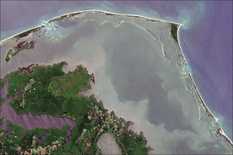
Cape Hatteras and the barrier islands of Norh Carolina
Most archipelagos are formed when volcanoes erupt from the ocean floor; these are called oceanic islands. The islands of the Hawaiian archipelago, for example, were formed by a series of volcanic eruptions that began more than 80 million years ago and are still active today (See Above). Archipelagos can also form as a result of erosion, sedimentary deposits, rising sea level, and other geographic processes. The Florida Keys are an example of a coral cay archipelago, which form when ocean currents transport sediments that gradually build up on the reef surface.
Continental fragments are archipelagos that have separated from a continental land mass due to the Earth’s tectonic movements. The Farallon Islands off the coast of California are an example of continental fragments. Continental archipelagos, such as British Columbia’s Inside Passage, are islands that form close to the coast of a continent.
Archipelagos are sometimes defined by political boundaries. The Gulf Archipelago off the Pacific Coast forms part of a larger archipelago that geologically includes Washington State’s San Juan Islands. While the Gulf Archipelago and San Juan Islands are geologically related, they are not technically included in the same archipelago due to manmade geopolitical borders.
Lagoons
Lagoons are bodies of water separated from larger bodies of water by natural barriers such as sandbars, barrier reefs and coral reefs. The word "lagoon" derives from the Italian word laguna, which means "pond" or "lake." [Source: NOAA]
Although lagoons are well defined geographically, the word “lagoon” is sometimes used as a name for a larger region that contains one or more lagoons. For example, Laguna Madre on the Texas Gulf Coast is actually made up of smaller bays and lagoons, while Laguna Beach in Southern California is actually a beach and not a lagoon at all.
There are two types of lagoons: atoll and coastal. Atoll lagoons form when an island completely subsides beneath the water, leaving a ring of coral that continues to grow upwards. At the center of the ring is a body of water that is often deep. The combination of coral growth and water creates a lagoon. It may take as long as 300,000 years for an atoll formation to occur.
Coastal lagoons form along gently sloping coasts. They are generally shallower than atoll lagoons and tend to be separated from the ocean by an island, reef, or sand bank. Most of the time, coastal lagoons are connected to the ocean by an inlet.
Sea level rise, the amount of existing sediment, and tidal range all contribute to the formation of coastal lagoons. Younger and more dynamic than atoll lagoons, coastal lagoons may have shorter “lifespans” due to their exposed locations on the shore.
For information on other island features See Coastal Area Features
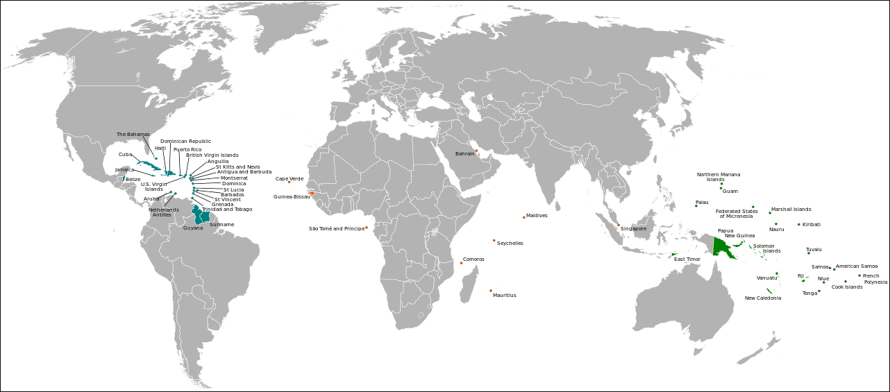
small island nations
Small Island Nations and Territories
By some reckonings there are 47 small island nations and territories. A couples of the nations here — like Cuba and Papua New Guinea — are kind of big while others similar in size — Madagascar, for example, are left off. Other list contain countries like Belize, Guinea-Bissau and Suriname that are connected to the mainland but have things in common with small island nations. Rising sea levels, overfishing and water shortages affect small island nations. Many small island nations rely on tourism for a good chunk of their income..
Caribbean
1) Anguilla
2) Antigua and Barbuda
3) Aruba
4) Bahamas
5) Barbados
6) British Virgin Islands
7) Cuba
8) Dominica
9) Dominican Republic
10) Grenada
11) Haiti
12) Jamaica
13) Montserrat
14) Netherlands Antilles
15) Puerto Rico
16) Saint Kitts and Nevis
17) Saint Lucia
18) Saint Vincent and the Grenadines
19) Trinidad and Tobago
20) United States Virgin Islands
Pacific
1) American Samoa
2) Cook Islands
3) Federated States of Micronesia
4) Fiji
5) French Polynesia
6) Guam
7) Kiribati
8) Marshall Islands
9) Nauru
10) New Caledonia
11) Niue
12) Northern Mariana Islands
13) Palau
14) Papua New Guinea
15) Samoa
16) Solomon Islands
17) Timor-Leste
18) Tonga
19) Tuvalu
20) Vanuatu
Africa, Indian Ocean and the Middle East
1) Bahrain
2) Cape Verde
3) Comoros
4) Maldives
5) Mauritius
6) São Tomé and Príncipe
7) Seychelles
Alliance of Small Island States (AOSIS) is an intergovernmental organization of low-lying coastal and small island countries. AOSIS was established in 1990, ahead of the Second World Climate Conference. The main purpose of the alliance is to consolidate the voices of Small Island Developing States (SIDS) to address global warming. These island countries are particularly vulnerable to climate change and its related effects on the ocean, including sea level rise, coastal erosion and saltwater intrusion. The members are among the nations least responsible for climate change, having contributed less than one percent to the world's greenhouse gas emissions. These states advocate for international policy and mechanisms for addressing the inequity of climate impacts. [Source: Wikipedia]
Member states: Atlantic Ocean (3 countries): Cabo Verde, Guinea-Bissau, São Tomé and Príncipe; Caribbean (16 countries): Antigua and Barbuda, Bahamas, Barbados, Belize, Cuba, Dominica, Dominican Republic, Grenada, Guyana, Haiti, Jamaica, Saint Kitts and Nevis, Saint Lucia, Saint Vincent and the Grenadines, Suriname, Trinidad and Tobago; Indian Ocean (4 countries): Comoros, Maldives, Seychelles, Mauritius; Pacific Ocean (15 countries): Cook Islands, Fiji, Kiribati, Marshall Islands, Federated States of Micronesia, Nauru, Niue, Palau, Papua New Guinea, Samoa, Solomon Islands, Timor-Leste, Tonga, Tuvalu, Vanuatu. South China Sea: Singapore
Image Sources: Wikimedia Commons; YouTube, NOAA
Text Sources: National Oceanic and Atmospheric Administration (NOAA) noaa.gov; “Introduction to Physical Oceanography” by Robert Stewart , Texas A&M University, 2008 uv.es/hegigui/Kasper ; Wikipedia, National Geographic, Live Science, BBC, Smithsonian, New York Times, Washington Post, Los Angeles Times, The New Yorker, Reuters, Associated Press, Lonely Planet Guides and various books and other publications.
Last Updated March 2023