Home | Category: Coastal Areas
WETLANDS

Fonseca Gulf, Nicaragua A wetland is an area of land that is saturated with water. There are many different kinds of wetlands and many ways to categorize them. NOAA classifies wetlands into five general types: marine (ocean), estuarine (estuary), riverine (river), lacustrine (lake), and palustrine (marsh). Common names for wetlands include marshes, estuaries, mangroves, mudflats, mires, ponds, fens, swamps, deltas, coral reefs, billabongs, lagoons, shallow seas, bogs, lakes, and floodplains, to name just a few!
Often found alongside waterways and in floodplains, wetlands vary widely due to differences in soil, topography, climate, water chemistry, and vegetation. Large wetland areas may also be comprised of several smaller wetland types.
Wetland habitats serve essential functions in an ecosystem, including acting as water filters, providing flood and erosion control, and furnishing food and homes for fish and wildlife. They do more than sustain plants and animals in the watershed, however. Many wetlands are not wet year-round because water levels change with the seasons. During periods of excessive rain, wetlands absorb and slow floodwaters, which helps to alleviate property damage and may even save lives.
Wetlands also absorb excess nutrients, sediments, and other pollutants before they reach rivers, lakes, and other waterbodies. They are also great spots for fishing, canoeing, hiking, and bird-watching, and are enjoyable outdoor "classrooms" for people of all ages.
Related Articles: COASTAL AREAS: PROCESSES, LANDFORMS AND LIFE ioa.factsanddetails.com ; ISLANDS: TYPES, HOW THEY FORM, FEATURES AND NATIONS ioa.factsanddetails.com ; BEACHES: SAND, SURF AND FOAM ioa.factsanddetails.com ; BEACH SAFETY, DANGERS AND HAZARDS ioa.factsanddetails.com ; TIDAL POOLS, INTERTIDAL ZONE AND LIFE FOUND THERE ioa.factsanddetails.com ; SEAGRASS— FEATURES, ECOSYSTEMS AND THE WORLD’S OLDEST AND BIGGEST PLANTS ioa.factsanddetails.com ; SEAWEED: FOOD, HEALTH, FARMING AND CLIMATE CHANGE ioa.factsanddetails.com ; MANGROVES: CHARACTERISTICS, CONSERVATION AND ROLE IN CLIMATE CHANGE ioa.factsanddetails.com
Websites and Resources: National Oceanic and Atmospheric Administration (NOAA) noaa.gov; “Introduction to Physical Oceanography” by Robert Stewart , Texas A&M University, 2008 uv.es/hegigui/Kasper ; Woods Hole Oceanographic Institute whoi.edu ; Cousteau Society cousteau.org ; Monterey Bay Aquarium montereybayaquarium.org
RECOMMENDED BOOKS:
“The World of the Salt Marsh: Appreciating and Protecting the Tidal Marshes of the Southeastern Atlantic Coast” by Charles Seabrook (2013) Amazon.com
“The Biology of Mangroves and Seagrasses” by Peter J. Hogarth Amazon.com
“The Botany of Mangroves” by P. Barry Tomlinson Amazon.com
“Coastal And Estuarine Processes” by Peter Nielsen Amazon.com
“Waves, Tides and Shallow-Water Processes” Open University(1989) Amazon.com
“Tides: The Science and Spirit of the Ocean” by Jonathan White Amazon.com
“Ecology of Coastal Waters: With Implications For Management” by K. H. Mann Amazon.com
“Introduction to Coastal Engineering and Management” by J William Kamphuis Amazon.com
“Introduction to Coastal Processes and Geomorphology” by Robin Davidson-Arnott, Bernard Bauer, et al. Amazon.com
“Physical Oceanography of Coastal and Shelf Seas” by B. Johns Amazon.com
“Descriptive Physical Oceanography” by Lynne Talley (2017) Amazon.com
“Essentials of Oceanography” by Alam Trujillo and Harold Thurman Amazon.com
“The Blue Machine: How the Ocean Works” by Helen Czerski, explains how the ocean influences our world and how it functions. Amazon.com
“How the Ocean Works: An Introduction to Oceanography” by Mark Denny (2008) Amazon.com
Salt Marshes

Salt marsh in Core Banks, North Carolina
Salt marshes are coastal wetlands that are flooded and drained by salt water brought in by the tides. They are marshy because the soil may be composed of deep mud and peat. Peat ismade of decomposing plant matter that is often several feet thick. Peat is waterlogged, root-filled, and very spongy. Because salt marshes are frequently submerged by the tides and contain a lot of decomposing plant material, oxygen levels in the peat can be extremely low — a condition called hypoxia. Hypoxia is caused by the growth of bacteria which produce the sulfurous rotten-egg smell that is often associated with marshes and mud flats. [Source: NOAA]
Salt marshes occur worldwide, particularly in middle to high latitudes. Thriving along protected shorelines, they are a common habitat in estuaries. In the U.S., salt marshes can be found on every coast. Approximately half of the nation's salt marshes are located along the Gulf Coast.
These intertidal habitats are essential for healthy fisheries, coastlines, and communities — and they are an integral part of our economy and culture. They also provide essential food, refuge, or nursery habitat for more than 75 percent of fisheries species, including shrimp, blue crab, and many finfish.
Salt marshes also protect shorelines from erosion by buffering wave action and trapping sediments. They reduce flooding by slowing and absorbing rainwater and protect water quality by filtering runoff, and by metabolizing excess nutrients.
Estuaries
Estuaries are places where freshwater from rivers mixes with salt water from the sea. They are usually found where rivers meet the sea — in bays and or around river deltas and often embrace swamps and mud flats (expanses of mud exposed at low tide).

Amazonas estuary (NASA)
Estuaries are muddy places filled with mud produced by sediments carried down from rivers. Often exposed at low tide, this is mud is a thick, sticky ooze capable of yanking boots off of feet and is so fine grained that gases from decomposed plant life can not escape. The trapped gas often have sulphur or hydrogen sulfide in it and these produces the rotten eggs smell often associated with swamps.
Estuaries are delicate ecosystems with conditions that are constantly changing. Much of the change is tidally driven but weather patterns, seasonal cycles, and climate change also affect and can change conditions in estuaries. During high tides and oceans storms they are often inundated with salt water. When they are heavy rains on the land and rivers become swollen they fill with fresh water. When the tide is low the estuarine mud is covered by air.
Changing conditions are a necessary part of healthy, functioning estuaries Tides flush the system and provide nutrients to keep food webs functional. By doing this, tides create constantly changing conditions of exposure to air or increased levels of water in an estuarine environment. Because of tides, the water levels in an estuary are going up and down several times a day. Estuarine organisms can adapt quite well to these changing conditions in estuaries. For example, fish or crabs are mobile and can move as needed throughout the day to adjust to changes in the estuary. [Source: NOAA]
Estuaries are beautiful places, and popular destination for fishing, boating, birding and hiking. They have beaches, flowing grasses, marshes, creeks, and streams. This salty freshwater mix is where life begins and is the nursing grounds for 75 percent of the fish caught in the U.S. Estuaries are lined with marshes and seagrasses that filter water flowing to the ocean and act as a buffer protecting us from coastal storms.. These valuable reserves are living laboratories for scientists and an a primary target of governmental and non-governmental conservation.
Estuarine Life
Estuaries are among the most productive ecosystems, producing more food per acre in most cases than the most fertile farmland. Many animals rely on estuaries for food, places to breed, and migration stopovers. They are also home to unique plant and animal communities that have adapted to brackish water — a mixture of fresh water draining from the land and salty seawater.
 Estuaries are made up of many different types of habitats. These habitats can include oyster reefs, coral reefs, rocky shores, submerged aquatic vegetation, marshes, and mangroves. There are also different animals that live in each of these different habitats. Fish, shellfish, and migratory birds are just a few of the animals that can live in an estuary. The Chesapeake Bay, as one example, includes several different habitats. There are oyster reefs where oysters, mud crabs, and small fish may be found. Also in the Bay, there is submerged aquatic vegetation where seahorses, blue crabs, and other fish live. Finally, there is open water where sea turtles or rays can be found.
Among the most abundant creatures in the freshwater parts of an estuary are worms. A quarter million sludge worms can be found in a square meters of upper esturine mud. Among the most abundant creatures in the saltwater parts of an estuary are shrimps and young fish. Other creatures include burrowing lugworms, which consume mud, digesting organic material and excreting the minerals; cockles, which lie in the mud and raise siphons that extract nutrients from the water. Plants grow where the mud is bound together with green algae enough so that roots can take hold.
Creatures that live in estuaries must be able to deal with changing conditions. If they can the rewards are great because estuaries contains more food than almost any other environment. Creatures that live near the shores need defenses to prevent them from drying out when the tide is out. Some make sure they are surrounded by wet mud when the tide is out. Others seal themselves in shells or tubes until the water returns.
Most estuarine creatures are vulnerable to attacks by hungry predators, mostly birds such as herons, egrets, and ducks. Many of these birds have unique bills that are adapted for apprehending particular prey. Knots and redshanks have long bills used to pull worms and shrimps from the mud. Ringed plovers use the short,sharp bills to extract the fleshy animals from spiral shells. Oystercatchers are able to attack mollusks by both prying open their shellsand picking holes into shells with their bills.
Mudskippers
Mudskippers are any of the 23 extant species of amphibious fish from the subfamily Oxudercinae of the goby family Oxudercidae.

Gambian mudskippers
Mudskippers are small fish found in mudflats that spend a great deal of time out of water. There are the only fish that feed, court and defend their territories on land. Residing in Old World mangrove swamps and muddy estuaries from West Africa to Papua New Guinea and Australia, they spend about half their time on land and can live up to week without water. The largest species reach lengths of about 20 centimeters.
Mudskippers are somewhat similar to the first creatures that moved from the seas to land and evolved into amphibians, reptiles, dinosaurs, mammals and other terrestrial animals. Most species feed on plankton and algae. Some feed on worms, crustaceans and insects and other food and small animals they can extract from the mud.
Mudskippers can breath on both land and in the water. Like all fish they have gills. But what makes them unique are the little chambers they have outside their gills which entrap water and enables them to breath on land, sort of like a scuba tank in reverse. To breath in this way they need to regularly fill their mouths with water. They can also absorb oxygen through their skin like a frog does but to do this they need to keep their skin wet and often roll around in the mud to achieve that end.
See Separate Article STRANGE FISH IN ASIA: GIANTS, SNAKEHEADS AND MUDSKIPPERS factsanddetails.com
Maritime Forest
Maritime forests protect our shorelines from ongoing movement of the coast. They are found along shorelines, estuaries and coastal barrier islands and support a great diversity of plants and animals. Trees, bushes, and other plants in maritime forests and estuaries withstand strong winds, periodic flooding, and salt spray. Many species of mammals and reptiles make the forests their home, and thousands of birds migrate to maritime forests each year. [Source: NOAA]
A good example of a maritime forest is the Currituck Banks Reserve, located on the Outer Banks of North Carolina. The western, ocean side of Currituck consists of sand dunes of beach grass and sea oats, which front a tightly woven canopy of shrub-like thickets of wax myrtle, holly, and stunted oaks. The canopy acts as a windscreen to protect the forest's less tolerant interior trees, often consisting of American holly, beach olive, ironwood, loblolly pine, red maple, and live oak. On the other side of the barrier island's maritime forest lies the estuary of Currituck Sound, where fresh water meets the ocean's salt water. This shallow intertidal area is home to the estuary's abundant flora and fauna.
Like all barrier islands, maritime forests are constantly changing and on the move. On Currituck, for example, one can see stumps of deciduous trees along the sandy beach. These trees were once in the center of the island, but due to the constantly changing shoreline, they are now mostly submerged in the ocean. Maritime forests, like all estuaries, are essential for storm protection. They also conserve important nutrients and groundwater.
Ghost Forest
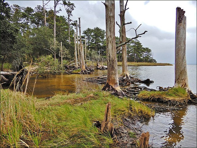
ghost forest in Nags Head, North Carolina
A ghost forest is the watery remains of a once verdant woodland. As sea level rises, more and more saltwater encroaches on the land. Along the world’s coasts and estuaries, invading seawater advances and overtakes the fresh water that deciduous trees rely upon for sustenance. The salty water slowly poisons living trees, leaving a haunted ghost forest of dead and dying timber. Still standing in or near brackish water, the decaying trees of a ghost forest resemble giant graying pillars that protrude into the air.
Researchers report that the rapid increase in ghost forests represents a dramatic visual picture of environmental changes along coastal plains located at or near sea level. In many areas, rising sea levels combine with land sinking from the last ice age, as is currently happening in the Chesapeake Bay watershed.
The Mississippi Delta region of Louisiana is undergoing changes due to rising waters, the sinking of Earth's crust, and sediments compacting along the Mississippi River. With land and water constantly shifting, woodlands die and are buried in open water. This is apparent along North Carolina’s maritime forests, where only a glimpse of once peaceful and verdant groves, now ghost forests, remain.
Wetlands Conservation
Preserving coastal areas and mangroves is vital to people that live in coastal areas, providing them with fish and other seafood and offers protection from storms and tsunamis. Natural coastal environments and mangroves also play a vital role in absorbing carbon dioxide and combating climate change. All types of coastal wetlands help to prevent millions of dollars in damage from flooding and save hundreds of hours of labor to repair storm damage.
One method of slowing climate change impacts is to incorporate coastal wetlands into the carbon market through the buying and selling of carbon offsets. This approach creates a financial incentive for restoration and conservation projects by helping to alleviate federal and state carbon taxes aimed at discouraging the use of fossil fuels. When fewer greenhouse gases are emitted, less pollution is created. When there is less pollution to tax, the process benefits not only the environment but also the financial well-being of the community doing the restoration. [Source: NOAA]
NOAA’s National Estuarine Research Reserves and their partners are working to make wetlands conservation and restoration profitable while lessening greenhouse gas emissions through blue carbon financial markets. These markets balance projects that feature heat-trapping emissions with contributions that take carbon out of the atmosphere. Efforts thus far have produced the first-ever U.S. guide that makes salt marsh restoration eligible for international carbon markets; research that documents carbon storage capabilities in the marsh; workshops and school curricula on the topic; and newsletters and technical assistance.
Something that has a significant effect on our daily lives and is stored within the largest system of water on our planet must be a household name, right? Not necessarily. Have you ever heard of blue carbon? Chances are the answer is no, but perhaps you know more than you realize.

Marsh Organ
The "marsh organ" is a simple instrument that helps scientists study sea level rise. Scientists are always looking for ways to measure sea-level rise and its long-term effects on coastal processes. To that end, the University of South Carolina and NOAA’s National Centers for Coastal Ocean Science developed a simple device called a “marsh organ” (because its graduated “pipes” resemble those of an organ) to determine how well an estuary may respond to rising sea levels. [Source: NOAA]
Setting up the marsh organ is a very muddy process. Scientists working to install the instrument may find themselves waist-deep in the soft marsh sediments! Once the organ is in place, they fill the tubes with mud and plant marsh grasses in each one. In a year or two, they return to the marsh organ to harvest the grass and measure how much it has grown.
Each “pipe” of the marsh organ represents a varying water-level "elevation.” As the tides ebb and flow, the marsh and the pipes are subject to rising and falling water levels. Depending on the amount of flooding and other factors, the marsh plants grow accordingly. The data is then used to inform a model that helps scientists forecast the future health of the marsh.
Image Sources: Wikimedia Commons; YouTube, Animal Diversity Web, NOAA
Text Sources: National Oceanic and Atmospheric Administration (NOAA) noaa.gov; “Introduction to Physical Oceanography” by Robert Stewart , Texas A&M University, 2008 uv.es/hegigui/Kasper ; Wikipedia, National Geographic, Live Science, BBC, Smithsonian, New York Times, Washington Post, Los Angeles Times, The New Yorker, Reuters, Associated Press, Lonely Planet Guides and various books and other publications.
Last Updated March 2023