Home | Category: Oceans and Sea Life
OCEANS
 Oceans cover 71 percent of the earth’s surface. The Pacific alone is larger than all the continents combined. If the earth’s crust was smoothed out so that the ocean floors and continents were all level, sea water would cover the earth at a depth of 2,680 meters (8,800 feet). If the water was evaporated the entire earth would be covered by 12 meters (40 feet) of salt.
The oceans have an average depth of 3.65 kilometers (2.27 miles, about 12,000 feet). The oceans are so deep that Everest could be placed in the Mariana Trench — the deepest point in the ocean — and be covered by a kilometer of water. Measured from the ocean floor, Mauna Kea on the Big Island of Hawaii is over 10,000 meters high, making it the largest mountain on Earth.
The oceans are great reservoirs of energy, minerals and gases. Water holds heat much more efficiently than air and ocean water absorbs 90 percent of the energy it receives. The oceans also absorb about half the carbon dioxide produced by human activity and blamed for global warming. Despite all this oceans are relatively unexplored, especially the vast expanses that don’t have rich fisheries, coral reefs, oil, minerals or popular research spots like deep-sea vents.
The oceans are more complex and less understood than the weather. Marine scientists often describe oceans as the earth's circulatory system, performing numerous vital functions which make the planet habitable, such as creating more than half our oxygen, driving weather systems while modulating the atmosphere, as well as providing us with vital resources. One of the main reason we understand so little about the sea and what is in it is because it much harder to explore than land.
Related Articles:
SEAS AND OCEANS: DEFINITIONS, FEATURES AND THE MAIN ONES ioa.factsanddetails.com
OCEANS OF THE WORLD: CHARACTERISTICS, FEATURES, RELATIONSHIPS ioa.factsanddetails.com
PHYSICAL FEATURES OF THE OCEAN FLOOR: TRENCHES, VENTS, MOUNTAINS ioa.factsanddetails.com
ISLANDS: TYPES, HOW THEY FORM, FEATURES AND NATIONS ioa.factsanddetails.com
LARGE WAVES: ROUGE WAVES, METEOTSUNAMIS AND THE BIGGEST WAVES EVER ioa.factsanddetails.com
OCEAN CURRENTS ioa.factsanddetails.com
SURVIVORS AT SEA: ADRIFT FOR MONTHS, ALONE IN A RAFT AND 480 METERS UNDERWATER ioa.factsanddetails.com
Websites and Resources: National Oceanic and Atmospheric Administration (NOAA) noaa.gov; “Introduction to Physical Oceanography” by Robert Stewart , Texas A&M University, 2008 uv.es/hegigui/Kasper ; Woods Hole Oceanographic Institute whoi.edu ; Cousteau Society cousteau.org ; Monterey BayAquarium montereybayaquarium.org
RECOMMENDED BOOKS:
“The Unnatural History of the Sea” by Callum Roberts (Island Press (2009). Roberts is a professor of marine conservation at the University of York in England Amazon.com
“Ocean: The World's Last Wilderness Revealed” by Robert Dinwiddie , Philip Eales, et al. (2008) Amazon.com
“Into the Great Wide Ocean: Life in the Least Known Habitat on Earth” by Sönke Johnsen (2024) Amazon.com
“An Introduction to the World's Oceans” by Keith A. Sverdrup (1984) Amazon.com
“The Sea Around Us” by Rachel Carson, an influential work that highlights the importance of ocean conservation (1950) Amazon.com
“The Life & Love of the Sea” by Lewis Blackwell Amazon.com
“Song for the Blue Ocean” by Carl Safina (1998) Amazon.com
“Blue Hope: Exploring and Caring for Earth's Magnificent Ocean” by Sylvia Earle (2014) Amazon.com
“National Geographic Ocean: A Global Odyssey” by Sylvia Earle (2021) Amazon.com
“Deep: Freediving, Renegade Science, and What the Ocean Tells Us About Ourselves” by James Nestor, investigates the ocean and human physiology through freediving. Amazon.com
“The Log from the Sea of Cortez” by John Steinbeck (Penguin Classics) (1951) Amazon.com
“The Ocean Book: The Stories, Science, and History of Oceans” by DK (2025) Amazon.com
“Ocean Art: From the Shore to the Deep” by Helen Scales (2025) Amazon.com
Sea Level
Just as the surface of the Earth is not flat, the surface of the ocean is not flat. The surface of the sea changes at different rates around the globe. For instance, the absolute water level height is higher along the West Coast of the United States than the East Coast. Understanding trends in sea level, as well as the relationship between global and local sea level, provides critical information about the impacts of the Earth's climate on our ocean and atmosphere. Estimates of sea level rise is based on measurements from satellite radar altimeters that vary globally.

lava enters the sea in Hawaii The term “global sea level” refers to the average height of all of the Earth's ocean basins. "Global sea level rise" refers to the increase in the average global sea level trend. "Local sea level" refers to the height of the water measured along the coast relative to a specific point on land. Tide stations measure local sea level. "Relative sea level trends" reflect changes in local sea level over time. This relative change is the one most critical for many coastal applications, including coastal mapping, marine boundary delineation, coastal zone management, coastal engineering, sustainable habitat restoration design, and the general public enjoying their favorite beach.
Global sea level has been rising over the past century, and the rate has increased in recent decades. Sea level rise at specific locations may be more or less than the global average due to many local factors: subsidence, ocean currents, variations in land height, and whether the land is still rebounding from the compressive weight of Ice Age glaciers.
Sea level is primarily measured using tide stations and satellite laser altimeters. Tide stations around the globe tell us what is happening at a local level — the height of the water as measured along the coast relative to a specific point on land. Satellite measurements provide us with information on how the ocean surface is changing — at a particular location or on the average across the entire ocean. Taken together, these tools tell us how our ocean sea levels are changing over time.
In the Indian Ocean there is geoid low — 2.6 thousands square-kilometer (million-square-mile) region where Earth’s gravity is unusually weak and sea level sits 91.5 to 107 meters (300 to 350 feet lower than surrounding waters. In the early 2020s, scientists finally pieced together the most convincing explanation for why this has occurred.
See Million-Square-Mile Gravity Hole in the Indian Ocean Under PHYSICS OF THE OCEAN: PRESSURE, SOUND, LIGHT, GRAVITY factsanddetails.com
Amount of Water in the Ocean
The ocean holds about 97 percent of the Earth's water; the remaining three percent is distributed in many different places, including glaciers and ice, below the ground, in rivers and lakes, and in the atmosphere. [Source: NOAA]
According to the U.S. Geological Survey, there are over 1,385,999,652.41 cubic kilometers (332,519,000 cubic miles) of water on the planet. A cubic kilometers is the volume of a cube measuring one kilometers on each side. Of this vast volume of water, NOAA's National Geophysical Data Center estimates that 1338000000 cubic kilometers (321,003,271 cubic miles) is in the ocean. That's enough water to fill about 352,670,000,000,000,000,000 gallon-sized milk containers or 1,335,000,000,000,000,000,000 liter water bottles!
Of the tiny percentage that's not in the ocean, about two percent is frozen up in glaciers and ice caps. Less than one percent of all the water on Earth is fresh. A tiny fraction of water exists as water vapor in our atmosphere.
Why Oceans Are Important
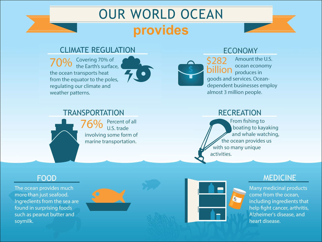
The world ocean provides many benefits. Here are seven things the ocean does for humans and the planet: 1) The air we breathe: The ocean produces over half of the world's oxygen and absorbs 50 times more carbon dioxide than our atmosphere. 2) Climate regulation: Covering 70 percent of the Earth's surface, the ocean transports heat from the equator to the poles, regulating our climate and weather patterns. 3) Transportation: Seventy-six percent of all U.S. trade involves some form of marine transportation. 4) Recreation: From fishing to boating to kayaking and whale watching, the ocean provides us with many unique activities. 5) Economic benefits: The U.S. ocean economy produces $282 billion in goods and services and ocean-dependent businesses employ almost three million people. 6) Food: The ocean provides more than just seafood; ingredients from the sea are found in surprising foods such as peanut butter and soymilk. 7) Medicine: Many medicinal products come from the ocean, including ingredients that help fight cancer, arthritis, Alzheimer's disease, and heart disease. [Source: NOAA]
When discussing why oceans are important to humans and ecology, some scientists highlight three broad themes.Robert Stewart wrote in the “Introduction to Physical Oceanography”: 1) We get food from the ocean. Hence we may be interested in processes which influence the sea just as farmers are interested in the weather and climate. The ocean not only has weather such as temperature changes and currents, but the oceanic weather fertilizes the sea. The atmospheric weather seldom fertilizes fields except for the small amount of nitrogen fixed by lightning. [Source: Robert Stewart, “Introduction to Physical Oceanography”, Texas A&M University, 2008]
2) We use the ocean. We build structures on the shore or just offshore. We use the ocean for transport. We obtain oil and gas below the ocean. And, we use the ocean for recreation, swimming, boating, fishing, surfing, and diving. Hence we are interested in processes that influence these activities, especially waves, winds, currents, and temperature.
3) The ocean influence the atmospheric weather and climate. The ocean influence the distribution of rainfall, droughts, floods, regional climate, and the development of storms, hurricanes, and typhoons. Hence we are interested in air-sea interactions, especially the fluxes of heat and water across the sea surface, the transport of heat by the ocean, and the influence of the ocean on climate and weather patterns.
Layers of the Ocean
Bodies of water are made up of layers, determined by temperature. According to The New Yorker: In “Moby-Dick,”Ishmael perceives the sea to be “indefinite as God,” but in fact the ocean is a place of considerable structure, with discrete sections layered across it horizontally. The sea’s uppermost layer is its brightest and smallest part, extending about two hundred meters from the surface. The vast majority of life in the ocean inhabits it. Tiny plants there generate half of Earth’s oxygen, much of which remains in the water. When they die, they fall several hundred meters, where vast colonies of bacteria consume their carcasses, using up tons of oxygen in the process. In this zone...“respiration dominates,” and the water’s oxygen content reaches its minimum. Deeper still, the ocean descends into total darkness: the midnight zone, which makes up ninety per cent of the sea, though it contains only two per cent of its life. The water is as cold as thirty degrees F (-1 degree C). Oxygen-rich water from Earth’s poles, moving toward the equator, flows to this part of the sea. [Source: The New Yorker, May 14, 2011]
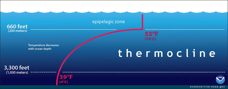
The top surface layer is called the epipelagic zone, and is sometimes referred to as the "ocean skin" or "sunlight zone." This layer interacts with the wind and waves, which mixes the water and distributes the warmth. At the base of this layer is the thermocline. A thermocline is the transition layer between the warmer mixed water at the surface and the cooler deep water below. It is relatively easy to tell when you have reached the thermocline in a body of water because there is a sudden change in temperature. In the thermocline, the temperature decreases rapidly from the mixed layer temperature to the much colder deep water temperature. [Source: NOAA]
Robert Stewart wrote in the “Introduction to Physical Oceanography”: Wind blowing on the ocean stirs the upper layers leading to a thin mixed layer at the sea surface having constant temperature and salinity from the surface down to a depth where the values differ from those at the surface. The magnitude of the difference is arbitrary, but typically the temperature at the bottom of the layer must be no more than 0.02–0.1◦ colder than at the surface. [Source: Robert Stewart, “Introduction to Physical Oceanography”, Texas A&M University, 2008]

The mixed layer is roughly 10–200 meters thick over most of the tropical and mid-latitude belts. The depth and temperature of the mixed layer varies from day to day and from season to season in response to two processes: 1) Heat fluxes through the surface heat and cool the surface waters. Changes in temperature change the density contrast between the mixed layer and deeper waters. The greater the contrast, the more work is needed to mix the layer downward and visa versa. 2) Turbulence in the mixed layer mixes heat downward. The turbulence depends on the wind speed and on the intensity of breaking waves. Turbulence mixes water in the layer, and it mixes the water in the layer with water in the thermocline.
The mid-latitude mixed layer is thinnest in late summer when winds are weak, and sunlight warms the surface layer. At times, the heating is so strong, and the winds so weak, that the layer is only a few meters thick. In fall, the first storms of the season mix the heat down into the ocean thickening the mixed layer, but little heat is lost. In winter, heat is lost, and the mixed layer continues to thicken, becoming thickest in late winter. In spring, winds weaken, sunlight increases, and a new mixed layer forms.
Below the mixed layer, water temperature decreases rapidly with depth except at high latitudes. The range of depths where the rate of change, the gradient of temperature, is large is called the thermocline. The mixed layer tends to be saltier than the thermocline between 10◦ and 40◦ latitude, where evaporation exceeds precipitation. At high latitudes the mixed layer is fresher because rain and melting ice reduce salinity. In some tropical regions, such as the warm pool in the western tropical Pacific, rain also produces a thin fresher mixed layer.
Thermocline
A thermocline is the transition layer between warmer mixed water at the ocean's surface and cooler deep water below. In the thermocline, temperature decreases rapidly from the mixed upper layer of the ocean (called the epipelagic zone) to much colder deep water in the thermocline (mesopelagic zone). Below 3,300 feet to a depth of about 13,100 feet, water temperature remains constant. At depths below 13,100 feet, the temperature ranges from near freezing to just above the freezing point of water as depth increases. [Source: NOAA]
In the ocean, the depth and strength of the thermocline vary from season to season and year to year. It is semi-permanent in the tropics, variable in temperate regions (often deepest during the summer), and shallow to nonexistent in the polar regions, where the water column is cold from the surface to the bottom.
Thermoclines also play a role in meteorological forecasting. For example, hurricane forecasters must consider not just the temperature of the ocean's skin (the sea surface temperature), but also the depth of warm water above the thermocline. Water vapor evaporated from the ocean is a hurricane's primary fuel. The depth of the thermocline is the measure of the size of the "fuel tank" and helps to predict the risk of hurricane formation.
The shape of the thermocline varies slightly with the seasons. This is the seasonal thermocline. The permanent thermocline extends from below the seasonal thermocline to depths of 1500–2000 meters. At high latitudes, there may be a cooler, fresher layer above the permanent thermocline. [Source: Robert Stewart, “Introduction to Physical Oceanography”, Texas A&M University, 2008]
How Deep is the Ocean?
The average depth of the ocean is about 3,688 meters (12,100 feet). The deepest part of the ocean is called the Challenger Deep and is located beneath the western Pacific Ocean in the southern end of the Mariana Trench, which runs several hundred kilometers southwest of the U.S. territorial island of Guam. Challenger Deep is approximately 10,935 meters (35,876 feet) deep. It is named after the HMS Challenger, whose crew first sounded the depths of the trench in 1875. [Source: NOAA]
Suzanne Oconnell of Wesleyan University wrote in The Conversation: Explorers started making navigation charts showing how wide the ocean was more than 500 years ago. But it’s much harder to calculate how deep it is. If you wanted to measure the depth of a pool or lake, you could tie a weight to a string, lower it to the bottom, then pull it up and measure the wet part of the string. In the ocean you would need a rope thousands of feet long. [Source: Suzanne OConnell, Harold T. Stearns Professor of Earth Science, Wesleyan University, The Conversation, April 4, 2022]
In 1872 the HMS Challenger, a British Navy ship, set sail to learn about the ocean, including its depth. It carried 181 miles (291 kilometers) of rope. During their four-year voyage, the Challenger crew collected samples of rocks, mud and animals from many different areas of the ocean. They also found one of the deepest zones, in the western Pacific, the Mariana Trench which stretches for 1,580 miles (2,540 kilometers).
Today scientists know that on average the ocean is 2.3 miles (3.7 kilometers) deep, but many parts are much shallower or deeper. To measure depth they use sonar, which stands for Sound Navigation And Ranging. A ship sends out pulses of sound energy and measures depth based on how quickly the sound travels back.
The deepest parts of the ocean are trenches — long, narrow depressions, like a trench in the ground, but much bigger. The HMS Challenger sampled one of these zones at the southern end of the Mariana Trench, which might be the deepest point in the ocean. Known as the Challenger Deep, it is 35,768 to 36,037 feet deep — almost 7 miles (11 kilometers).

Oceans on Other Planets
Scientists believe many planets and moons have subsurface oceans. Evidence points to such oceans even within our own solar system. But Earth is the only known planet (or moon) to have consistent, stable bodies of liquid water on its surface. In our solar system, Earth orbits around the sun in an area called the habitable zone. The temperature within this zone, along with an ample amount of atmospheric pressure, allow water to be liquid for long periods of time. [Source: NOAA]
Scientists believe several moons within our solar system have significant subsurface liquid water deposits. Saturn’s moon Enceladus and Jupiter’s moon Europa are two examples. Both appear to have salty, liquid oceans covered with thick layers of ice at the surface. Scientists have observed water plumes erupting from Enceladus, and believe similar plumes can be found on Europa. The existence of these geysers also tells scientists that these moons have a source of energy, perhaps from gravitational forces or radiation — energy that keeps the oceans liquid under the ice and could even support life. Scientists hypothesize that Europa's hidden ocean is salty, tidal, and causes its ice surface to move, resulting in large fractures that are clearly visible. Although Europa lies outside of our solar system's habitable zone, it may have the ingredients needed to support life — water, energy, and organic compounds.
Beyond our solar system, scientists have found thousands of exoplanets — planets that orbit other stars — including some in the habitable zone. Using mathematical models, researchers estimate that more than a quarter of known exoplanets may have liquid water, though the majority would have subsurface oceans like those on Europa and Enceladus.
The search for liquid water is critical to the search for life beyond Earth. While scientists originally focused the search on finding planets with liquid water on their surface, that thinking is changing. Here on Earth, we have examples of life flourishing in some of the most extreme conditions, such as the complex ecosystems around hydrothermal vents on the seafloor. Scientists are reconsidering whether life could exist below an icy surface, even within our solar system on moons like Europa and Enceladus.
“Scientists have long suspected there were these reservoirs of cold water vapor hiding in the outer regions of planet-forming disks, but until now we’ve only found signs of water vapor in hot regions closer to the suns,” Hogerheijde told the Washington Post, “Since the comets and cold asteroids are formed in the outer reaches, this was a problem for the theory that comets delivered the water to Earth. But now we have the cold reservoir in the region where comets are formed, and so the theory gets considerably stronger.” The logical extension, he said, is that water has also been delivered to some of the billions of exoplanets known to exist beyond our solar system, meaning there are likely to be many “ocean worlds” throughout the galaxies.
Titan's Underground Ocean
Data from NASA's Cassini spacecraft have revealed Saturn's moon Titan likely harbors a layer of liquid water under its ice shell. The finding appeared in the journal Science. "Cassini's detection of large tides on Titan leads to the almost inescapable conclusion that there is a hidden ocean at depth," said Luciano Iess, the paper's lead author and a Cassini team member at the Sapienza University of Rome, Italy. "The search for water is an important goal in solar system exploration, and now we've spotted another place where it is abundant." [Source: NASA, June 28, 2012]
The evidence is tidal. Saturn's powerful gravity stretches and deforms Titan as the moon moves around the gas giant planet. If Titan were composed entirely of stiff rock, the gravitational attraction of Saturn should cause bulges, or solid "tides," on the moon only 3 feet (1 meter) in height. Instead, the data show Saturn creates solid tides approximately 30 feet (10 meters) in height. This suggests Titan is not made entirely of solid rocky material.
At first, scientists were not sure Cassini would be able to detect the bulges caused by Saturn's pull on Titan. Cassini succeeded, however, by measuring Titan's gravitational field during six close flybys from Feb. 27, 2006, to Feb. 18, 2011. These gravity measurements, collected with the aid of NASA's Deep Space Network (DSN), revealed the size of Titan's tides.
"We were making ultrasensitive measurements, and thankfully Cassini and the DSN were able to maintain a very stable link," said Sami Asmar, a Cassini team member at NASA's Jet Propulsion Laboratory in Pasadena, Calif. "The tides on Titan pulled up by Saturn aren't huge compared to the pull the biggest planet, Jupiter, exerts on some of its moons. But, short of being able to drill on Titan's surface, the gravity measurements provide the best data we have of Titan's internal structure."
Image Sources: Wikimedia Commons; YouTube, NOAA
Text Sources: National Oceanic and Atmospheric Administration (NOAA) noaa.gov; “Introduction to Physical Oceanography” by Robert Stewart , Texas A&M University, 2008 uv.es/hegigui/Kasper ; Wikipedia, National Geographic, Live Science, BBC, Smithsonian, New York Times, Washington Post, Los Angeles Times, The New Yorker, Reuters, Associated Press, Lonely Planet Guides and various books and other publications.
Last Updated November 2025