Home | Category: Physical Oceanography
PHYSICS OF THE OCEAN

Air-Sea Fluxes: Wind and buoyancy forces acting on the upper ocean mixed layer. Solar radiation (Qsw), net longwave radiation (Qlw), latent heat flux (Qlat), and sensible heat flux (Qsen) combine to form the net surface heat flux (Q0). Qpen is the solar radiation penetrating the base of the mixed layer
According to the “Introduction to Physical Oceanography” important process in study of oceanography that have a physical science component include: 1) Heat storage and transport in the ocean; 2) The exchange of heat with the atmosphere and the role of the ocean in climate; 3) Wind and thermal forcing of the surface mixed layer; 4) The wind-driven circulation including the Ekman circulation, Ekman pumping of the deeper circulation, and upwelling; 5) The dynamics of ocean currents, including geostrophic currents and the role of vorticity; 6) The formation of water types and masses; 7) The deep circulation of the ocean; 8) Equatorial dynamics, El Niño, and the role of the ocean in weather; 9) Numerical models of the circulation; 10) Waves in the ocean including surface waves, inertial oscillations, tides, and tsunamis; 11) Waves in shallow water, coastal processes, and tide predictions. [Source: Robert Stewart, “Introduction to Physical Oceanography”, Texas A&M University, 2008]
If the ocean were scaled down to a width of 20 centimeters inches it would have depths about the same as the thickness of a piece of paper. As a result, the velocity field in the ocean is nearly two-dimensional. Vertical velocities are much smaller than horizontal velocities. The volume of ocean water exceeds the capacity of the ocean basins, and the ocean overflows on to the continents creating continental shelves.
Temperature and salinity (the amount of salt in something) are key to understanding the ocean and how it functions. Density, heat fluxes, evaporation, rain, river inflow, and freezing and melting of sea ice all influence the distribution of temperature and salinity at the ocean’s surface. Changes in temperature and salinity can increase or decrease the density of water at the surface, which can lead to convection. If water from the surface sinks into the deeper ocean, it retains a distinctive relationship between temperature and salinity which helps oceanographers track the movement of deep water. In addition, temperature, salinity, and pressure are used to calculate density. The distribution of density inside the ocean is directly related to the distribution of horizontal pressure gradients and ocean currents. For all these reasons, we need to know the distribution of temperature, salinity, and density in the ocean.
Related Articles:
OCEANOGRAPHY AND STUDYING THE SEA ioa.factsanddetails.com
CHEMISTRY OF THE OCEAN: SALT, OXYGEN AND CARBON ioa.factsanddetails.com
TEMPERATURE IN THE OCEAN ioa.factsanddetails.com
WAVES IN THE OCEAN: TYPES, CAUSES, AND EFFORTS TO DESCRIBE, PREDICT AND MEASURE THEM ioa.factsanddetails.com
OCEAN CURRENTS: FORCES, CONCEPTS, TYPES, MAPS ioa.factsanddetails.com
OCEAN TIDES: TYPES, TERMS, FORCES, MEASUREMENTS AND PREDICTIONS ioa.factsanddetails.com
OCEANS, WINDS AND WEATHER ioa.factsanddetails.com
DEVICES, TECHNOLOGY AND MEASUREMENTS USED IN OCEANOGRAPHY ioa.factsanddetails.com
MODELS IN OCEANOGRAPHY ioa.factsanddetails.com
Websites and Resources: National Oceanic and Atmospheric Administration (NOAA) noaa.gov; “Introduction to Physical Oceanography” by Robert Stewart , Texas A&M University, 2008 uv.es/hegigui/Kasper ; Woods Hole Oceanographic Institute whoi.edu ; Cousteau Society cousteau.org ; Monterey Bay Aquarium montereybayaquarium.org
RECOMMENDED BOOKS:
“Atmospheric and Oceanic Fluid Dynamics: Fundamentals and Large-Scale Circulation” by Geoffrey K. Vallis (2006) Amazon.com
“Essentials of Atmospheric and Oceanic Dynamics” by Geoffrey K. Vallis (2019) Amazon.com
“The Blue Machine: How the Ocean Works” by Helen Czerski, explains how the ocean influences our world and how it functions. Amazon.com
“How the Ocean Works: An Introduction to Oceanography” by Mark Denny (2008) Amazon.com
“The Science of the Ocean: The Secrets of the Seas Revealed” by DK (2020) Amazon.com
“Descriptive Physical Oceanography” by Lynne Talley (2017) Amazon.com
“Essentials of Oceanography” by Alam Trujillo and Harold Thurman Amazon.com
“The Unnatural History of the Sea” by Callum Roberts (Island Press (2009) Amazon.com
“Ocean: The World's Last Wilderness Revealed” by Robert Dinwiddie , Philip Eales, et al. (2008) Amazon.com
“An Introduction to the World's Oceans” by Keith A. Sverdrup (1984) Amazon.com
“Blue Hope: Exploring and Caring for Earth's Magnificent Ocean” by Sylvia Earle (2014) Amazon.com
“National Geographic Ocean: A Global Odyssey” by Sylvia Earle (2021) Amazon.com
Important Forces That Affect the Ocean

Circulation forces of the Atlantic Meridional Overturning Current
According to the “Introduction to Physical Oceanography”: 1) Gravity is the dominant force. The weight of the water in the ocean produces pressure. Changes in gravity, due to the motion of sun and moon relative to earth produces tides, tidal currents, and tidal mixing in the interior of the ocean. Buoyancy is the upward or downward force due to gravity acting on a parcel of water that is more or less dense than other water at its level. For example, cold air blowing over the sea cools surface waters causing them to be more dense than the water beneath. Gravity acting on the difference in density results in a force that causes the water to sink. Horizontal pressure gradients are due to the varying weight of water in different regions of the ocean. [Source: Robert Stewart, “Introduction to Physical Oceanography”, Texas A&M University, 2008]
2) Friction is the force acting on a body as it moves past another body while in contact with that body. The bodies can be parcels of water or air. Wind stress is the friction due to wind blowing across the sea surface. It transfers horizontal momentum to the sea, creating currents. Wind blowing over waves on the sea surface leads to an uneven distribution of pressure over the waves. The pressure distribution transfers energy to the waves, causing them to grow into bigger waves.
3) Pseudo-forces are apparent forces that arise from motion in curvilinear or rotating coordinate systems. For example, Newton’s first law states that there is no change in motion of a body unless a resultant force acts on it. Yet a body moving at constant velocity seems to change direction when viewed from a rotating coordinate system. The change in direction is due to a pseudo-force, the Coriolis force.
4) Coriolis Force is the dominant pseudo-force influencing motion in a coordinate system fixed to the earth. Coriolis Results from motion in a rotating coordinate system Friction Is due to relative motion between two fluid parcels.
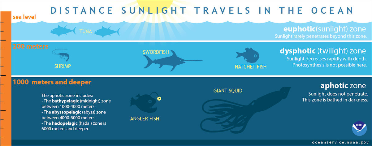
Light in the Ocean, How Far Does It Go?
Sunlight entering the water may travel about 1,000 meters into the ocean under the right conditions, but there is rarely any significant light beyond 200 meters. Only a small amount of light penetrates beyond this depth. [Source: NOAA]
The ocean is divided into three zones based on depth and light level. 1) The upper 200 meters of the ocean is called the euphotic, or "sunlight," zone. This zone contains the vast majority of commercial fisheries such as tuna and is home to many protected marine mammals and sea turtles. 2) The zone between 200 meters and 1,000 meters is usually referred to as the “twilight” zone, but is officially the dysphotic zone. In this zone, the intensity of light rapidly dissipates as depth increases. Such a minuscule amount of light penetrates beyond a depth of 200 meters that photosynthesis is no longer possible. ‘Photic’ is a derivative of ‘photon,’ the word for a particle of light.
3) The aphotic zone exists in depths below 1,000 meters. Sunlight does not penetrate to these depths and the zone is bathed in darkness. The aphotic zone is further subdivided into the bathypelagic zone (or midnight zone) between 1,000 and 4,000 meters, the abyssopelagic (or the abyss) between 4,000 and 6,000 meters, and the hadopelagic zone (or hadal zone) 6,000 meters and deeper.
Although some sea creatures depend on light to live, others can do without it. In the dysphotic (twilight) zone sunlight decreases rapidly with depth; photosynthesis is not possible here. Shrimp, swordfish, and hatchet fish are often found here. The aphotic zone is home to angler fish and giant squid and presumably many undiscovered and unnamed creatures.
Why Is the Ocean Blue and Green?
The ocean like the sky looks blue because shorter wavelengths like blue that scatter widely are visible. Longer wavelengths like red do not scatter and thus are not visible. The ocean is blue because water absorbs colors in the red part of the light spectrum. Like a filter, this leaves behind colors in the blue part of the light spectrum for us to see. The ocean may also take on green, red, or other hues as light bounces off of floating sediments and particles in the water. Most of the ocean, however, is completely dark. Hardly any light penetrates deeper than 200 meters (656 feet), and no light penetrates deeper than 1,000 meters (3,280 feet). [Source: NOAA]
According to NASA: Pure water is perfectly clear — but if there is a lot of water, and the water is very deep so that there are no reflections off the sea floor, the water appears as a very dark navy blue. The reason the ocean is blue is due to the absorption and scattering of light. The blue wavelengths of light are scattered, similar to the scattering of blue light in the sky but absorption is a much larger factor than scattering for the clear ocean water. In water, absorption is strong in the red and weak in the blue, thus red light is absorbed quickly in the ocean leaving blue. Almost all sunlight that enters the ocean is absorbed, except very close to the coast. The red, yellow, and green wavelengths of sunlight are absorbed by water molecules in the ocean. When sunlight hits the ocean, some of the light is reflected back directly but most of it penetrates the ocean surface and interacts with the water molecules that it encounters. The red, orange, yellow, and green wavelengths of light are absorbed so that the remaining light we see is composed of the shorter wavelength blues and violets.
If there are any particles suspended in the water, they will increase the scattering of light. In coastal areas, runoff from rivers, resuspension of sand and silt from the bottom by tides, waves and storms and a number of other substances can change the color of the near-shore waters. Some types of particles (in particular, the cells of phytoplankton, also referred to as algae) can also contain substances that absorb certain wavelengths of light, which alters its characteristics.
Green usually comes from plankton.Phytoplankton are very small, single-celled plants, generally smaller than the size of a pinhead that contain a green pigment called chlorophyll. All plants (on land and in the ocean) use chlorophyll to capture energy from the sun and through the process known as photosynthesis convert water and carbon dioxide into new plant material and oxygen.
Although microscopic, phytoplankton can bloom in such large numbers that they can change the color of the ocean to such a degree that we can measure that change from space. The green pigment of chlorophyll preferentially absorb the red and blue portions of the light spectrum (for photosynthesis) and reflect green light. So, the ocean over regions with high concentrations of phytoplankton will appear as certain shades, from blue-green to green, depending upon the type and density of the phytoplankton population.
The basic principle behind the remote sensing of ocean color from space is this: the more phytoplankton in the water, the greener it is....the less phytoplankton, the bluer it is. There are other substances that may be found dissolved in the water that can also absorb light. Since these substances are usually composed of organic carbon, researchers generally refer to these substances as colored dissolved organic matter, CDOM for short. Brown often comes soil and sediments washed into the sea from the land or from currents that stir up a relatively shallow ocean bottom. During algae blooms the sea can turn florescent green, pink or red (See
The study of ocean color helps scientists gain a better understanding of phytoplankton and their impact on the Earth system. These small organisms can affect a system on a very large scale such as climate change. Phytoplankton use carbon dioxide for photosynthesis and in turn provide almost half the oxygen we breathe. The larger the world's phytoplankton population, the more carbon dioxide gets pulled from the atmosphere, hence, the lower the average temperature due to lower volumes of this greenhouse gas. Scientists have found that a given population of phytoplankton can double its numbers about once per day. In other words, phytoplankton respond very rapidly to changes in their environment.

Water Density in the Ocean
Robert Stewart wrote in the “Introduction to Physical Oceanography”: “During winter, cold water formed at the surface sinks to a depth determined by its density relative to the density of the deeper water. Currents then carry the water to other parts of the ocean. At all times, the water parcel moves to stay below less dense water and above more dense water. The distribution of currents within the ocean depends on the distribution of pressure, which depends on the variations of density inside the ocean. [Source: Robert Stewart, “Introduction to Physical Oceanography”, Texas A&M University, 2008]
If we want to follow water movement within the ocean, we need to know the distribution of density within the ocean. The calculation of water movement requires measurements of density with an accuracy of a few parts per million. This is not easy. Absolute Density of water can only be measured in special laboratories, and only with difficulty. The best accuracy is 1 : 2.5 × 105 = 4 parts per million. To avoid the difficulty of working with absolute density, oceanographers use density relative to density of pure water.
In practice, density is not measured, it is calculated from in situ measurements of pressure, temperature, and conductivity using the equation of state for sea water. This can be done with an accuracy of two parts per million. Density of water at the sea surface is typically 1027 kilograms per cubic meter. If we are studying surface layers of the ocean, we can ignore compressibility.
Pressure in the Ocean
Pressure increases with ocean depth. At sea level, the air that surrounds us presses down on our bodies at 14.7 pounds per square inch. You don't feel it because the fluids in your body are pushing outward with the same force. Dive down into the ocean even a few feet, though, and a noticeable change occurs. You can feel an increase of pressure on your eardrums. This is due to an increase in hydrostatic pressure, the force per unit area exerted by a liquid on an object. The deeper you go under the sea, the greater the pressure of the water pushing down on you. For every 33 feet (10.06 meters) you go down, the pressure increases by one atmosphere. [Source: NOAA]
Pressure is routinely measured by many different types of instruments. The SI unit of pressure is the pascal (Pa), but oceanographers normally report pressure in decibars (dbar), where: 1 dbar = 104 Pa because the pressure in decibars is almost exactly equal to the depth in meters. Thus 1000 dbar is the pressure at a depth of about 1000 meters. The Strain Gage is the simplest and cheapest instrument, and it is widely used. Accuracy is about ±1 percent. [Source: Robert Stewart, “Introduction to Physical Oceanography”, Texas A&M University, 2008]
Much more accurate measurements of pressure can be made by measuring the natural frequency of a vibrating tungsten wire stretched in a magnetic field between diaphragms closing the ends of a cylinder. Pressure distorts the diaphragm, which changes the tension on the wire and its frequency. The frequency can be measured from the changing voltage induced as the wire vibrates in the magnetic field. Accuracy is about ±0.1 percent, or better when temperature controlled. Precision is 100–1000 times better than accuracy. The instrument is used to detect small changes in pressure at great depths. Snodgrass (1964) obtained a precision equivalent to a change in depth of ±0.8 mm at a depth of 3 kilometers.
Very accurate measurements of pressure can also be made by measuring the natural frequency of a quartz crystal cut for minimum temperature dependence. The best accuracy is obtained when the temperature of the crystal is held constant. The accuracy is ±0.015 percent, and precision is ±0.001 percent of full-scale values. Quartz Bourdon Gage has accuracy and stability comparable to quartz crystals. It too is used for long-term measurements of pressure in the deep sea.

Why Is the Ocean Colder at Depth?
Cold water has a higher density than warm water. Water gets colder with depth because cold, salty ocean water sinks to the bottom of the ocean basins below the less dense warmer water near the surface. The sinking and transport of cold, salty water at depth combined with the wind-driven flow of warm water at the surface creates a complex pattern of ocean circulation called the 'global conveyor belt.' [Source: NOAA]
In contrast, the Earth gets hotter and hotter at depth primarily because the energy of radioactive decay is leaking outwards from the core of the planet. While this geothermal energy is transferred to ocean water along the seafloor, the effect is so small that it's immeasurable by direct means.
Why? The actual amount of heat generated per square meter of Earth is quite small, especially compared to the amount of heat necessary to warm the ocean. Geothermal energy emanating from the Earth averages only about one tenth of a watt per square meter. At that rate of heat flow (without taking ocean currents into account), it would take well over a year just to heat the bottom meter of the ocean by one degree Centigrade.
However, the ocean is not standing still. Complex deep ocean currents driven by density variations in temperature and salinity are constantly replacing the bottom layer of ocean water with colder water. The great ocean conveyor moves water around the globe. Cold, salty water is dense and sinks to the bottom of the ocean while warm water is less dense and remains on the surface.
Measurement of Salinity with Depth
Temperature, salinity, and pressure are measured as a function of depth using various instruments or techniques, and density is calculated from the measurements. Temperature is usually measured by a thermistor. Conductivity is measured by a conductivity cell. Pressure is measured by a quartz crystal. According to the “Introduction to Physical Oceanography”: Bathythermograph (BT) was a mechanical device that measured temperature vs depth on a smoked glass slide. The device was widely used to map the thermal structure of the upper ocean, including the depth of the mixed layer before being replaced by the expendable bathythermograph in the 1970s. [Source: Robert Stewart, “Introduction to Physical Oceanography”, Texas A&M University, 2008]
Nansen Bottles were deployed from ships stopped at hydrographic stations. Hydrographic stations are places where oceanographers measure water properties from the surface to some depth, or to the bottom, using instruments lowered from a ship. Usually 20 bottles were attached at intervals of a few tens to hundreds of meters to a wire lowered over the side of the ship.
The distribution with depth was selected so that most bottles are in the upper layers of the water column where the rate of change of temperature in the vertical is greatest. A protected reversing thermometer for measuring temperature was attached to each bottle along with an unprotected reversing thermometer for measuring depth. The bottle contains a tube with valves on each end to collect sea water at depth. Salinity was determined by laboratory analysis of water sample collected at depth. After bottles had been attached to the wire and all had been lowered to their selected depths, a lead weight was dropped down the wire. The weight tripped a mechanism on each bottle, and the bottle flipped over, reversing the thermometers, shutting the valves and trapping water in the tube, and releasing another weight. When all bottles had been tripped, the string of bottles was recovered. The deployment and retrieval typically took several hours.
CTD Mechanical instruments on Nansen bottles were replaced beginning in the 1960s by an electronic instrument, called a CTD, that measured conductivity, temperature, and depth. The measurements are recorded in digital form either within the instrument as it is lowered from a ship or on the ship.

Sound in the Ocean
According to the “Introduction to Physical Oceanography”: Sound provides the only convenient means for transmitting information over great distances in the ocean. Sound is used to measure the properties of the sea floor, the depth of the ocean, temperature, and currents. Whales and other ocean animals use sound to navigate, communicate over great distances, and find food. [Source: Robert Stewart, “Introduction to Physical Oceanography”, Texas A&M University, 2008]
The sound speed in the ocean varies with temperature, salinity, and pressure: C = 1448.96 + 4.591 t − 0.05304 t 2 + 0.0002374 t 3 + 0.0160 Z (3.1) + (1.340 − 0.01025 t)(S − 35) + 1.675 × 10⁻⁷ Z2 − 7.139 × 10⁻¹³ t Z3 where C is speed in meters per second, t is temperature in Celsius, S is salinity, and Z is depth in meters. The equation has an accuracy of about 0.1 meters per second. Other sound-speed equations have been widely used, especially an equation proposed by Wilson (1960) which has been widely used by the U.S. Navy.
For typical oceanic conditions, C is usually between 1450 meters per second and 1550 meters per second. We can calculate the sensitivity of C to changes of temperature, depth, and salinity typical of the ocean. The approximate values are: 40 meters per second per 10◦C rise of temperature, 16 meters per second per 1000 meters increase in depth, and 1.5 meters per second per 1 increase in salinity. Thus the primary causes of variability of sound speed is temperature and depth (pressure). Variations of salinity are too small to have much influence.
If we plot sound speed as a function of depth, we find that the speed usually has a minimum at a depth around 1000 meters. The depth of minimum speed is called the sound channel. It occurs in all ocean, and it usually reaches the surface at very high latitudes.
The sound channel is important because sound in the channel can travel very far, sometimes half way around the earth. Here is how the channel works: Sound rays that begin to travel out of the channel are refracted back toward the center of the channel. Rays propagating upward at small angles to the horizontal are bent downward, and rays propagating downward at small angles to the horizontal are bent upward. Typical depths of the channel vary from 10 meters to 1200 meters depending on geographical area. Absorption of sound per unit distance depends on the intensity of the sound:. The 30,000 Hz signal used by typical echo sounders to map the ocean’s depths are little attenuated going from the surface to the bottom and back.
Uses of Sound in the Ocean
Very low frequency sounds in the sound channel, those with frequencies below 500 Hz have been detected at distances of megameters. In 1960 15-Hz sounds from explosions set off in the sound channel off Perth Australia were heard in the sound channel near Bermuda, nearly halfway around the world. Because low frequency sound can be heard at great distances, the US Navy, in the 1950s, placed arrays of microphones on the sea floor in deep and shallow water and connected them to shore stations. The Sound Surveillance System sosus, although designed to track submarines, has found many other uses. It has been used to listen to and track whales up to 1,700 kilometers away, and to find the location of sub-sea volcanic eruptions.
The depths of the ocean are mapped by echo sounders which measure the time required for a sound pulse to travel from the surface to the bottom and back. Depths measured by ship-based echo sounders have been used to produce maps of the sea floor. The maps have poor horizontal resolution in some regions because the regions were seldom visited by ships and ship tracks are far apart.
The depths of the ocean are also measured by satellite altimeter systems which profile the shape of the sea surface. The local shape of the surface is influenced by changes in gravity due to sub-sea features. Recent maps based on satellite altimeter measurements of the shape of the sea surface combined with ship data have depth accuracy of ±100 meters and horizontal resolutions of ±3 kilometers.
Speed and Distance of Sound Travel in the Ocean
Typically speed in the ocean travels at 5328 kilometers per hour (3,310 miles for hour,1480 meters per second). Speed depends primarily on temperature, less on pressure, and very little on salinity. The variability of sound speed as a function of pressure and temperature produces a horizontal sound channel in the ocean. Sound in the channel can travel great distances. Low-frequency sounds below 500 Hz can travel halfway around the world provided the path is not interrupted by land.
The distance that sound travels in the ocean varies greatly, depending primarily upon water temperature and pressure. While sound moves at a much faster speed in the water than in air, the distance that sound waves travel is primarily dependent upon ocean temperature and pressure. While pressure continues to increase as ocean depth increases, the temperature of the ocean only decreases up to a certain point, after which it remains relatively stable. These factors have a curious effect on how (and how far) sound waves travel. [Source: NOAA]
Imagine a whale is swimming through the ocean and calls out to its pod. The whale produces sound waves that move like ripples in the water. As the whale’s sound waves travel through the water, their speed decreases with increasing depth (as the temperature drops), causing the sound waves to refract downward. Once the sound waves reach the bottom of what is known as the thermocline layer, the speed of sound reaches its minimum. The thermocline is a region characterized by rapid change in temperature and pressure which occurs at different depths around the world. Below the thermocline "layer," the temperature remains constant, but pressure continues to increase. This causes the speed of sound to increase and makes the sound waves refract upward.
The area in the ocean where sound waves refract up and down is known as the "sound channel." The channeling of sound waves allows sound to travel thousands of miles without the signal losing considerable energy. In fact, hydrophones, or underwater microphones, if placed at the proper depth, can pick up whale songs and manmade noises from many kilometers away.
SOFAR
SOFAR, or Sound Fixing and Ranging Channel, is a naturally-occurring ocean 'channel' that allows sound to carry great distances. The ocean consists of many zones. Sound can travel through a zone for hundreds, sometimes thousands of kilometers. [Source: NOAA]

At the height of World War II, scientists tested a theory that low-frequency sound could travel long distances in the deep ocean. They deployed a hydrophone from their research vessel, which was anchored off of Woods Hole, Massachusetts. Some 900 miles away, another ship lowered a four-pound explosive to a specific depth below the ocean surface. Once detonated, the explosion propelled pulses of sound that traveled the 1,450 kilometers (900 hundred miles) from one ship to the other. For the first time, researchers heard what they termed SOFAR transmission. As the scientists noted, “The end of the sound channel transmission was so sharp that it was impossible for the most unskilled observer to miss it.”
How does SOFAR work? Think of the ocean as consisting of various zones, or layers — sort of like oil and vinegar salad dressing before it’s shaken up — except that ocean layers occur due to differences in salinity (salt content) and temperature variations. Saltier and colder water lie beneath less salty, warmer water.
Because of SOFAR, sound emitted at a certain depth bounces between these various layers and can travel for hundreds of miles. This up-and-down bending of low-frequency soundwaves allows soundwaves to travel great distances without the signal losing significant energy. By placing hydrophones at the axis of the sound channel, researchers can record sounds such as whale calls, earthquakes, and manmade noise occurring vast distances from the hydrophones. In some instances, low-frequency sounds can be heard across entire ocean basins.
Million-Square-Mile Gravity Hole in the Indian Ocean
In the Indian Ocean there is geoid low — 2.6 thousands square-kilometer (million-square-mile) region where Earth’s gravity is unusually weak and sea level sits 91.5 to 107 meters (300 to 350 feet lower than surrounding waters. In the early 2020s, scientists finally pieced together the most convincing explanation for why this has occurred. [Source: Marianne Guenot, Business Insider, July 7, 2023; Victor Tangermann, Futurism, July 1, 2023]
The anomaly likely took shape around 20 million years ago. It’s one of the strongest gravity lows on Earth and offers a rare look into deep-Earth dynamics and the long-term recycling of ancient seafloors. For decades, researchers assumed something directly beneath the anomaly must be causing the dip. But new computer models from the Indian Institute of Science suggest the real cause lies in dynamic processes around it, not underneath it.
About 120 million years ago, the breakup of the supercontinent Gondwana and the northward drift of India tore apart the ancient Tethys Ocean. As India collided with Eurasia, much of the Tethys seafloor sank deep into the mantle beneath Eastern Africa. that dense, ancient seafloor slowly melted, it produced plumes of hot, low-density magma. These buoyant plumes rose beneath the Indian Ocean, creating a vast region where the mantle is lighter than normal — effectively pulling the geoid downward and reducing local gravity. Surrounding high-density areas, such as the rising Tibetan Plateau, also amplify the contrast.
The Indian Ocean’s “gravity hole” is a lingering fingerprint of Earth’s ancient tectonic drama — the breakup of continents, the destruction of an ocean, and the rise of mantle plumes that continue to shape the planet from far below. Scientists still need direct evidence. Future ocean surveys will test whether the predicted magma plumes truly exist. Simulations align with geological history, but nature is more complex than any model.
Image Sources: Wikimedia Commons; YouTube, NOAA
Text Sources: National Oceanic and Atmospheric Administration (NOAA) noaa.gov; “Introduction to Physical Oceanography” by Robert Stewart , Texas A&M University, 2008 uv.es/hegigui/Kasper ; Wikipedia, National Geographic, Live Science, BBC, Smithsonian, New York Times, Washington Post, Los Angeles Times, The New Yorker, Reuters, Associated Press, Lonely Planet Guides and various books and other publications.
Last Updated November 2025