Home | Category: Ocean Environmental Issues
RED TIDES AND ALGAE BLOOMS

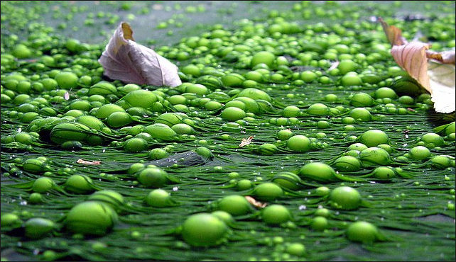
Phytoplankton bloom in the North Sea Red tides are dense blooms or massive concentration of oxygen-consuming microscopic algae that grow and spread at a great speed. Despite their name, most of the time they are not red (although they can be). They are usually different shades of brown and can be bright green. Once a red tide reaches critical mass, there is little that anyone can do other wait for it to end. A red tide can last anywhere from a few days to a few months. They are usually seasonally, typically occurring the fall in temperate climates.
A "red tide" is a common term used for a harmful algal bloom, or HABs, which occur when colonies of algae — simple plants that live in the sea and freshwater — grow out of control while producing toxic or harmful effects on people, fish, shellfish, marine mammals, and birds. The human illnesses caused by HABs, though rare, can be debilitating or even fatal. [Source: NOAA]
One of the best known HABs in the nation occurs nearly every summer along Florida’s Gulf Coast. This bloom, like many HABs, is caused by microscopic algae that produce toxins that kill fish and make shellfish dangerous to eat. The toxins may also make the surrounding air difficult to breathe. As the name suggests, the bloom of algae often turns the water red. HABs have been reported in every U.S. coastal state, and their occurrence may be on the rise. HABs are a national concern because they affect not only the health of people and marine ecosystems, but also the 'health' of local and regional economies.
A severe toxic algal bloom along Southern California’s coast in 2023 killed or sickening more than 1,000 marine animals—especially sea lions and dolphins—according to NOAA. Rescue groups fielded over 200 distress calls per day as domoic-acid–producing algae surged. The toxin accumulates in small fish like anchovies and sardines, then poisons the predators that eat them, causing disorientation, seizures, and often death. Santa Barbara and Ventura counties were among the hardest hit. While harmful algal blooms occur seasonally, scientists warn that warming oceans and climate change may be expanding the range and intensity of toxin-producing algae. [Source: Madeline Halpert, BBC, June 22, 2023]
Related Articles: POLLUTION IN THE SEA ioa.factsanddetails.com ; TRASH AND DEBRIS IN THE OCEAN AND EFFORTS TO CLEAN IT UP ioa.factsanddetails.com ; PLASTIC IN THE OCEAN ioa.factsanddetails.com ; OIL IN THE OCEAN: SPILLS, NATURAL SEEPAGE AND SHIPS ioa.factsanddetails.com ; WORST OIL SPILLS OF ALL TIME ioa.factsanddetails.com ; OCEAN ACIDIFICATION ioa.factsanddetails.com ; ENDANGERED CORAL REEFS AND THEIR RECOVERY AND REBIRTH ioa.factsanddetails.com ; GLOBAL WARMING AND CORAL REEFS ioa.factsanddetails.com
Websites and Resources: Animal Diversity Web (ADW) animaldiversity.org; National Oceanic and Atmospheric Administration (NOAA) noaa.gov; “Introduction to Physical Oceanography” by Robert Stewart , Texas A&M University, 2008 uv.es/hegigui/Kasper ; Fishbase fishbase.se ; Encyclopedia of Life eol.org ; Smithsonian Oceans Portal ocean.si.edu/ocean-life-ecosystems ; Woods Hole Oceanographic Institute whoi.edu ; Cousteau Society cousteau.org ; Monterey Bay Aquarium montereybayaquarium.org ; MarineBio marinebio.org/oceans/creatures
RECOMMENDED BOOKS:
“The Unnatural History of the Sea” by Callum Roberts (Island Press (2009) Amazon.com
“The Ocean of Life: The Fate of Man and the Sea” by Callum Roberts Amazon.com
“Plastic Soup: An Atlas of Ocean Pollution” by Michiel Roscam Abbing Amazon.com
“Blue Hope: Exploring and Caring for Earth's Magnificent Ocean” by Sylvia Earle (2014) Amazon.com
“The Empty Ocean” by Richard Ellis (2003) Amazon.com
“Oceans: The Threats to Our Seas and What You Can Do to Turn the Tide” by , Jon Bowermaster (2010) Amazon.com
“Oceans of Plastic: Understanding and Solving a Pollution Problem” by Tracey Gray (2022) Amazon.com
“Trash Vortex: How Plastic Pollution Is Choking the World's Oceans’ by Danielle Smith-Llera Amazon.com
“Dark Side of The Ocean: The Destruction of Our Seas, Why It Maters, and What We Can Do About It” by Albert Bates Amazon.com
“Ocean's End: Travels Through Endangered Seas” (2001)
by Colin Woodard Amazon.com
“Climate and the Oceans” (Princeton Primers in Climate) by Geoffrey K. Vallis Amazon.com
“The Encyclopedia of Weather and Climate Change: A Complete Visual Guide”
by Juliane L. Fry, Hans-F Graf, et al. Amazon.com
“Atmosphere, Ocean and Climate Dynamics: An Introductory Text” (International Geophysics by John Marshall, R. Alan Plumb Amazon.com
“Great Ocean Conveyor: Discovering the Trigger for Abrupt Climate Change”
by Wally Broecker Amazon.com
“Beyond Extinction: The Eternal Ocean―Climate Change & the Continuity of Life”
by Wolfgang Grulke Amazon.com
“The Blue Machine: How the Ocean Works” by Helen Czerski, explains how the ocean influences our world and how it functions. Amazon.com
“How the Ocean Works: An Introduction to Oceanography” by Mark Denny (2008) Amazon.com
“The Science of the Ocean: The Secrets of the Seas Revealed” by DK (2020) Amazon.com
“Atmospheric and Oceanic Fluid Dynamics: Fundamentals and Large-Scale Circulation” by Geoffrey K. Vallis (2006) Amazon.com
“Essentials of Oceanography” by Alam Trujillo and Harold Thurman Amazon.com
“Ocean: The World's Last Wilderness Revealed” by Robert Dinwiddie , Philip Eales, et al. (2008) Amazon.com
“The Sea Around Us” by Rachel Carson, an influential work that highlights the importance of ocean conservation (1950) Amazon.com
“The Life & Love of the Sea” by Lewis Blackwell Amazon.com
“Song for the Blue Ocean” by Carl Safina (1998) Amazon.com
“National Geographic Ocean: A Global Odyssey” by Sylvia Earle (2021) Amazon.com
Negative Impacts of Red Tides
Red tides kills fish and other aquatic life through suffocation by depriving them of oxygen and producing toxins that can paralyze marine life. Red Tides include blooms of non-toxic species that have harmful effects on marine ecosystems. For example, when masses of algae die and decompose, the decaying process can deplete oxygen in the water, causing the water to become so low in oxygen that animals either leave the area or die.
Red tides can poison seafood and cause the closing of beaches. Eating shellfish tainted by a red tide can cause food poisoning, vomiting and other nastiness and produce airborne toxins that cause throat and eye irritation, coughing, bloody noses and asthma fits. When red tides hit some coastal areas all events are cancelled and residents are encouraged to wear surgical masks.
Red tides kill everything from sea turtles to fish to horseshoe crabs. Algae can paralyze fish, clog their gills, and absorb enough oxygen to suffocate them. Sometimes red tides cover vast areas of the ocean surface and can extend down to the ocean floor and kill sponges, coral and starfish. Not all red tides are the same. Different kinds can be caused be caused by different species of algae.
Red tides can also affect animals up the food chain. Sick and dead sea lions, dolphins and pelicans have been linked to ingestion of fish and shellfish with high levels of domoic acid which builds up in the creatures during red tides and animals that eat them. Some of pelicans who consumed it, scientists said, literally have fallen out of the sky dead.
Sewage, industrial run off, urban pollution, storm run off, farming wastes, mining tailings, ranch run offs, and fertilizers can contribute to the development of a red tide. HABs can also be costly in economic terms as well. At present, HABs cause about $82 million in economic losses to the seafood, restaurant, and tourism industries each year. HABs reduce tourism, close beaches and shellfish beds, and decrease the catch from both recreational and commercial fisheries.
Causes of Red Tides
.jpg "20120517-Plankton Phytoplankton_bloom_in_the_Baltic_Sea_(July_3_2001).jpg")
Phytoplankton bloom in the Baltic Sea in 2001 Red tides are caused in part by plankton reproducing itself in large quantities due to large amounts and a steady supply of the nutrients nitrogen and phosphorous in the water. Sometimes red tides occur naturally, especially in places like the Gulf of Mexico where there is less water movement than in the Atlantic or Pacific. Often times, however, they are caused by the dumping of large amounts of waste water and sewage into the sea bay and waterways leading into the sea. When a red tide is at its peak, a liter of sea water may contain 10 million algae cells.
Harmful algal blooms (HABs) occur when colonies of algae — simple plants that live in the sea and freshwater — grow out of control while producing toxic or harmful effects on people, fish, shellfish, marine mammals, and birds. While we know of many factors that may contribute to HABs, how these factors come together to create a 'bloom' of algae is not well understood. [Source: NOAA]
Studies indicate that many algal species flourish when wind and water currents are favorable. In other cases, HABs may be linked to 'overfeeding.' This occurs when nutrients (mainly phosphorus, nitrogen, and carbon) from sources such as lawns and farmlands flow downriver to the sea and build up at a rate that 'overfeeds' the algae that exist normally in the environment. Some HABs have also been reported in the aftermath of natural phenomena like sluggish water circulation, unusually high water temperatures, and extreme weather events such as hurricanes, floods, and drought.
Not All Algal Blooms Are Harmful
Not all algal blooms are harmful. Most blooms, in fact, are beneficial because the tiny plants are food for animals in the ocean. In fact, they are the major source of energy that fuels the ocean food web. A small percentage of algae, however, produce powerful toxins that can kill fish, shellfish, mammals, and birds, and may directly or indirectly cause illness in people.
There are thousands of species of algae; most are beneficial and only a few of these produce toxins or have other harmful effects. Harmful algal blooms are blooms of species of algae that can have negative impacts on humans, marine and freshwater environments, and coastal economies. These blooms occur when phytoplankton, which are tiny microscopic plants, grow quickly in large quantities while producing toxic or harmful effects on people, fish, shellfish, marine mammals, and birds. [Source: NOAA]
A bloom does not have to produce toxins in order to be harmful to the environment. It can also be harmful by causing anoxic conditions where oxygen is depleted from the water. Blooms can block light to organisms lower in the water column, or even clog or harm fish gills.
Some algal blooms are beneficial. Phytoplankton are found at the base of the marine food chain therefore all other life in the ocean relies on phytoplankton. Blooms can also be a good indicator of environmental change not only in the water, but also on land.
Eutrophication
Harmful algal blooms, dead zones, and fish kills are the results of a process called eutrophication — which begins with the increased load of nutrients to estuaries and coastal waters. Eutrophication is a big word that describes a big problem in the nation's estuaries. Harmful algal blooms, dead zones, and fish kills are the results of a process called eutrophication — which occurs when the environment becomes enriched with nutrients, increasing the amount of plant and algae growth to estuaries and coastal waters. [Source: NOAA]
Eutrophication on a pond
Sixty-five percent of the estuaries and coastal waters in the contiguous U.S. that have been studied by researchers are moderately to severely degraded by excessive nutrient inputs. Excessive nutrients lead to algal blooms and low-oxygen (hypoxic) waters that can kill fish and seagrass and reduce essential fish habitats. Many of these estuaries also support bivalve mollusk populations (e.g., oysters, clams, scallops), which naturally reduce nutrients through their filter-feeding activities.
Eutrophication sets off a chain reaction in the ecosystem, starting with an overabundance of algae and plants. The excess algae and plant matter eventually decompose, producing large amounts of carbon dioxide. This lowers the pH of seawater, a process known as ocean acidification. Acidification slows the growth of fish and shellfish and can prevent shell formation in bivalve mollusks. This leads to a reduced catch for commercial and recreational fisheries, meaning smaller harvests and more expensive seafood.
Causes of Eutrophication
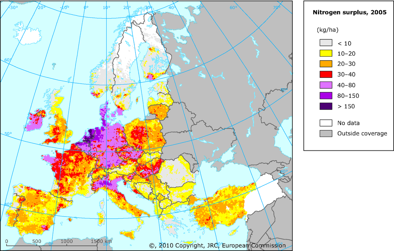
According to National Geographic: Eutrophic events have increased because of the rapid rise in intensive agricultural practices, industrial activities, and population growth. These three processes emit large amounts of nitrogen and phosphorous. These nutrients enter our air, soil, and water. Human activities have emitted nearly twice as much nitrogen and three times as much phosphorus as natural emissions.
Different regions of the world emit different levels of these nutrients. In developed countries, such as the United States and nations in the European Union, heavy use of animal manure and commercial fertilizers in agriculture are the main contributors to eutrophication. Runoff from large agricultural fields enters creeks and bays because of rain or irrigation practices.
In developing countries of Latin America, Asia, and Africa, untreated wastewater from sewage and industry mainly contribute to eutrophication. Factories and sewage facilities are less regulated than they are in developed countries, and sometimes wastewater is simply dumped into creeks, rivers, lakes, or the ocean.
Atmospheric sources of nitrogen also contribute to eutrophication in some areas of the world. Fossil fuels and fertilizers release nitrogen into the atmosphere. This atmospheric nitrogen is then redeposited on land and water through the water cycle — rain and snow.
Human Contributions to Algae Blooms
Harmful algal blooms are a natural process. There are records of HABs from early European colonists arriving to Florida in the 1500s. However, research points to an increase in the frequency and intensity of algal blooms in modern times due to environmental changes caused by humans. [Source: NOAA]
There are many examples of human activities that contribute to HABs: runoff from agriculture, dissolved chemicals introduced into water supplies via rainfall or irrigation, and effluent from sewage treatment plants all contribute to excess amounts of nutrients in our waterways. These nutrients are food for algae. In housing developments, for example, retention ponds are a common place to see freshwater HABs. All this runoff ends up in the water system, eventually making its way to the ocean.
Dead Zones

Eutrophication
Dead zones are areas where there is so much algae and bacteria that all the oxygen is sucked out of the water making it impossible for most life forms to exist. They exist in different spots around the globe. They create tons and tons and bacteria and algae. Few organism can live on them other than jellyfish. Fertilizer run off of and sewage seem to be big contributors to their creation. In some places swarms of jellyfish and poisonous bacteria that first appeared 2.7 billion years ago are taking over.
"Dead zone" is a more common term for hypoxia, which refers to a reduced level of oxygen in the water. Dead zones occur because of eutrophication (See Above). Less oxygen dissolved in the water is often referred to as a “dead zone” because most marine life either dies, or, if they are mobile such as fish, leave the area. Habitats that would normally be teeming with life become, essentially, biological deserts. [Source: NOAA]
Hypoxic zones can occur naturally, but scientists are concerned about the areas created or enhanced by human activity. There are many physical, chemical, and biological factors that combine to create dead zones, but nutrient pollution is the primary cause of those zones created by humans. Excess nutrients that run off land or are piped as wastewater into rivers and coasts can stimulate an overgrowth of algae, which then sinks and decomposes in the water. The decomposition process consumes oxygen and depletes the supply available to healthy marine life.
Places with Dead Zones
Dead zones increased by a third between 1997 and 2007. A total of 415 dead zones, with a combined area of 246,000 square kilometers — an area about the size of New Zealand — were identified in 2007. Large ones have occurred in the Black Sea, Baltic Sea, the East China Sea, and the Gulf of Mexico, with one caused by algae located at the mouth of the Mississippi River. Another large one began off of Oregon and spread northward to Washington and southward to California. Many of them are blamed on fertilizer run off. They rarely happen in nature, without some kind of push from mankind.
Associated Press reported: Across the planet, blooms have wrecked local ecosystems. Whales, turtles, dolphins and manatees have died, poisoned by algal toxins, in the Atlantic and Pacific. These toxins have infiltrated whole marine food chains and have, in rare cases, killed people, according to the U.N. science agency. In the Great Lakes of North America, Thailand and the Seychelles, the algae bloom green. In Florida they are red, in the North Atlantic they are chalky white, and in Puget Sound they are orange. The Irish call it the "sea ghost," and the Taiwanese refer to the blooms as "blue tears."
According to National Geographic: Hypoxic areas have increased dramatically from about 10 documented cases in 1960 to at least 169 in 2007. The majority of the world’s dead zones are located along the eastern coast of the United States, and the coastlines of the Baltic States, Japan, and the Korean Peninsula. The Chesapeake Bay, on the East Coast of the United States, has one of the first dead zones ever identified, in the 1970s. The Chesapeake’s high levels of nitrogen are caused by two factors: urbanization and agriculture. The western part of the bay is full of factories and urban centers that emit nitrogen into the air. Atmospheric nitrogen accounts for about a third of the nitrogen that enters the bay. The eastern part of the bay is a center of poultry farming, which produces large amounts of manure.
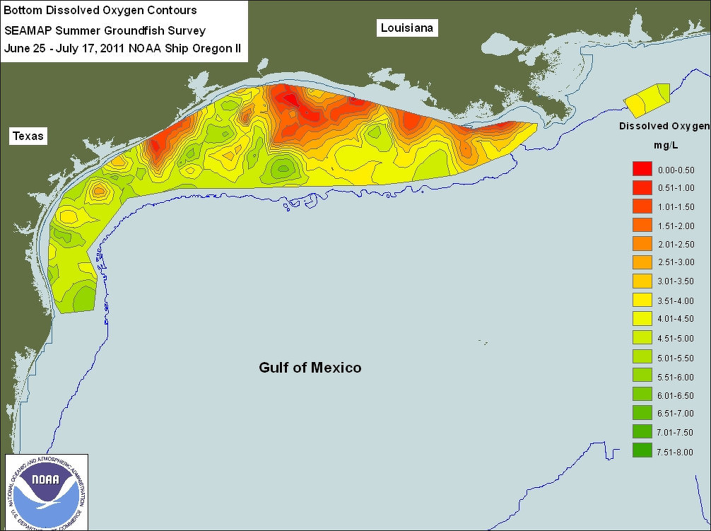
Dead Zone in the Gulf of Mexico
The Gulf of Mexico has a seasonal hypoxic zone that forms every year in late summer. Its size varies from fewer than 5,000 square kilometers (1,931 square miles) to approximately 22,000 square kilometers (8,494 square miles, or the size of Massachusetts). Concern over its increasing size led to the formation of the Mississippi River/Gulf of Mexico Watershed Nutrient Task Force in 1997. Its mission is to reduce the five-year running average of the Gulf of Mexico dead zone to less than 5,000 square kilometers.
The Baltic Sea is home to seven of the world’s 10 largest marine dead zones. Increased runoff from agricultural fertilizers and sewage has sped up the eutrophication process. Overfishing of Baltic cod has intensified the problem. Cod eat sprats, a small, herring-like species that eat microscopic zooplankton, which in turn eat algae. Fewer cod and more sprats mean more algae and less oxygen. The spreading dead zones are starting to reach the cod’s deep-water breeding grounds, further endangering the species.
Mexico-Size Algae Bloom Turns the Entire Arabian Sea Emerald Green
Reporting from Bandar Al-Rowdah, Oman, Sam McNeil of Associated Press wrote: The Gulf of Oman turns green twice a year, when an algae bloom the size of Mexico spreads across the Arabian Sea all the way to India. Scientists who study the algae say the microscopic organisms are thriving in new conditions brought about by climate change, and displacing the zooplankton that underpin the local food chain, threatening the entire marine ecosystem. Khalid al-Hashmi, a marine biologist at the Sultan Qaboos University in Oman, wrinkles his nose as the research vessel nears the bloom. "Sea stench," he says, referring to the algae's ammonia secretions. "It's here, you can smell it." He signals the boat to stop as it speeds beneath a gigantic rock arch off the coast of Muscat, the capital of Oman, an arid sultanate on the southeastern corner of the Arabian Peninsula. The captain kills the engine and drops anchor into a slick of bright green muck surrounded by crystal-clear blue water. [Source: Sam McNeil, Associated Press March 16, 2017]
The swarms of microscopic creatures beneath the surface of the Gulf of Oman were all but invisible 30 years ago — now they form giant, murky shapes that can be seen from satellites.
Referring to satellite images of swirls of chlorophyll spiraling across the world's oceans, Paula Bontempi, the manager for ocean carbon and biology projects at the U.S. space agency, told Associated Press "It's like a Van Gogh painting...Absolutely beautiful." It's less attractive up close, where it can be "almost guacamole-like" in some lakes. "It smells bad, it looks bad," she said.
Scientists based at the Lamont-Doherty Earth Observatory at Columbia University trace Oman's blooms to melting ice in the Himalayas. Less ice has raised temperatures in South Asia and strengthened the Indian Ocean's southwest monsoon. As this weather front moves across the Arabian Sea every year, it churned up oxygen-poor water thick with nutrients that have fueled the rise of a 1.2-billion-year old algae called noctiluca scintillans.
For the past 15 years, observatory biogeochemist Joaquim Goes, al-Hashmi and biological oceanographer Helga do Rosario Gomes have tracked blooms in the Arabian Sea using boats, satellites and remote sensors. Goes said the blooms have caused a "short-circuiting of the food chain," endangering other marine life. "Normally these things happen slowly, usually we talk about tens of hundreds of years. Here it's happening overnight," he said. "The transformation is happening before our eyes."
The algae blooms pose a number of threats to Oman, whose fishing and trading ships have plied these waters for centuries. Thick blooms reduce visibility, making it difficult for divers to repair undersea gas infrastructure. It can also clog the intake pipes of the desalinization plants that produce up to 90 percent of the country's fresh water. Fishermen call Oman's marine research center when they spot blooms.
Marine ecologist Ahmad al-Alawi adds these reports to four decades of observations before comparing them with satellite images of the swirling chlorophyll. He says the blooms are growing bigger and lasting longer, displacing the zooplankton at the bottom of the local food chain. The algae has attracted more whale sharks — a major draw for divers — but many tourists have cancelled their trips at the sight of the green, murky waves, said Ollie Clarke, a dive instructor at the Bandar al-Rowdah marina near Muscat.
It also poses a threat to the country's fisheries. An outbreak of a different kind of algae in 2008 led to the beaching of 50 tons of oxygen-starved fish, which rotted up and down the coast, al-Alawi said.
The researchers have found cause for both despair and hope by studying a live noctiluca culture in their lab: The blooms will likely spread as the Indian Ocean continues to absorb greenhouse gas emissions, but could be contained if they are sprayed with fresh water. Goes and Gomes hope to develop an early-warning system for Oman modeled on one operated by the U.S. National Oceanic and Atmospheric Administration in Florida But Saleh al-Mashari, who learned to sail and fish as a boy in the small coastal village where he still lives, and who now captains a researcher vessel, said the damage is already done. "The fish are migrating," he said. "They can't get enough air here."
Larger-Than-Average Gulf of Mexico ‘Dead Zone’ in 2021
In August 2021, NOAA-supported scientists announced that this year’s Gulf of Mexico “dead zone” — an area of low to no oxygen that can kill fish and marine life — was approximately 16,605 square kilometers (6,334 square miles), or equivalent to more than 1,62 million hectraes (4 million acres) of habitat potentially unavailable to fish and bottom species. The average hypoxic zone over the past five years is 13,935 square kilometers (5,380 square miles), which is 2.8 times larger than the 2035 target set by the Hypoxia Task Force. Since records began in 1985, the largest hypoxic zone measured was 22,730 square kilometers (8,776 square miles) in 2017. [Source: NOAA, August 3, 2021]
“The distribution of the low dissolved oxygen was unusual this summer,” said Nancy Rabalais, Ph.D.offsite link, professor at Louisiana State University and LUMCONoffsite link who is the principal investigator. “The area from the Mississippi River to the Atchafalaya River, which is usually larger than the area to the west of the Atchafalaya, was smaller. The area to the west of the Atchafalaya River was much larger. The low oxygen conditions were very close to shore with many observations showing an almost complete lack of oxygen.”
Surface waters were low in salinity across most of the study area, indicating that high freshwater runoff from the Mississippi River watershed affected the area. River discharge measured above normal for the three weeks prior to the research cruise. In June, NOAA forecasted an average-sized hypoxic zone of 4,880 square miles, based primarily on the Mississippi River discharge and nutrient runoff data from the U.S. Geological Survey. With average- to below-average discharge and nutrient loading this spring, the models predicted an average hypoxic zone to form during the time of the cruise. The forecast models assume typical weather conditions and do not have capacity to factor in storms or other wind events, which can disrupt the hypoxia zone around the time of the cruise. While the model results underestimated the measured size of the zone this year, they were within the expected margin of uncertainty for the forecast and provide further evidence of the robustness of the models to relate nutrient inputs to observed hypoxia size in the summer.
Excess nutrients stimulate algae growth Each year, excess nutrients from cities, farms and other sources in upland watersheds drain into the Gulf and stimulate algal growth during the spring and summer. The algae eventually die, sink and decompose. Throughout this process, oxygen-consuming bacteria decay the algae. The resulting low oxygen levels near the bottom are insufficient to support most marine life, rendering the habitat unusable and forcing species to move to other areas to survive. Exposure to hypoxic waters has been found to alter fish diets, growth rates, reproductionoffsite link, habitat use, and availability of commercially harvested species like offsite linkshrimp.
Combating Red Tides
A lack funds keeps many countries from tackling the problem aggressively. In some places authorities and scientists have tried to minimize the damage caused the algae blooms by pumping oxygen in the water and containing blooms by adding clay which acts as a magnet for algae. NASA uses satellites and floating robots to monitor algae blooms. The satellite technology has enabled scientists to link the algae to higher levels of air and water pollution in recent decades.
Scientists at the National Ocean Service have been monitoring and studying algae blooms for years to determine how to detect and forecast the location of the blooms. The goal is to give communities advance warnings so they can adequately plan for and deal with the adverse environmental and health effects associated with these 'red-tide' events.
NOAA's Harmful Algal Bloom (HAB) Operational Forecast System in the Gulf of Mexico identifies whether or not a bloom of algae is likely to contain a toxic species, where it is, how big it is, where it's headed, and if it could become more severe in the near future. Like a weather forecast, this system provides officials advance warning to test and close beaches and shellfish beds more precisely and for a shorter period of time. This system relies on satellite imagery, field observations, models, public health reports, and buoy data to provide information on bloom events. Forecasters create a public HAB conditions report using this data and information to provide the likelihood of respiratory irritation impacts to people in the area. Expert oceanographers at NOAA analyze available data and models in order to create accurate bulletins. To ensure the highest degree of accuracy, all operational HAB forecasts undergo secondary review prior to dissemination.
Nitrogen-based chemicals often fuel algae blooms
One of primary missions of NOAA's National Centers for Coastal Ocean Science is to empower communities to take action on Harmful Algal Bloom issues by developing detection tools and forecasts. NCCOS is involved in mitigating harmful algal blooms in a number of different ways and through several legislative measures. For example, the Harmful Algal Bloom Hypoxia Research and Control Act provides NOAA with a legal mandate to study HABS, to mitigate their effects, and to provide early warning for when and where blooms will occur. NOAA partners with other organizations throughout the country, as well, to support research through three funding opportunities:
According to National Geographic: Since 1967, the Chesapeake Bay Foundation has led a number of programs that aim to improve the bay’s water quality and curb pollution runoff. The Baltic Sea has become the first “macro-region” targeted by the European Union to combat pollution, dead zones, overfishing, and regional disputes. The EU is coordinating the Baltic Sea Strategy with eight EU member countries that border the Baltic Sea: Denmark, Estonia, Finland, Germany, Latvia, Lithuania, Poland, and Sweden.
Combating Red Tides with Oysters
In recent years, NOAA's National Centers for Coastal Ocean Science (NCCOS), in collaboration with NOAA's Northeast Fisheries Science Center, has enlisted estuaries' indigenous residents, namely, bivalve mollusks, to help slow and, in some cases, reverse the process of eutrophication, since they efficiently remove nutrients from the water as they feed on phytoplankton and detritus. [Source: NOAA]
A groundbreaking modeling project in Long Island Sound showed that the oyster aquaculture industry in Connecticut provides $8.5–$23 million annually in nutrient reduction benefits. The project also showed that reasonable expansion of oyster aquaculture could provide as much nutrient reduction as the comparable investment of $470 million in traditional nutrient-reduction measures, such as wastewater treatment improvements and agricultural best management practices.
The NOAA scientists used aquaculture modeling tools to demonstrate that shellfish aquaculture compares favorably to existing nutrient management strategies in terms of efficiency of nutrient removal and implementation cost. Documenting the water quality benefits provided by shellfish aquaculture has increased both communities' and regulators' acceptance of shellfish farming, not only in Connecticut but across the nation. In Chesapeake Bay, for example, nutrient removal policies include the harvesting of oyster tissue as an approved method, and in Mashpee Bay, Massachusetts, cultivation and harvest of oysters and clams are part of the official nutrient management plan.
Image Sources: Wikimedia Commons; YouTube, NOAA
Text Sources: National Oceanic and Atmospheric Administration (NOAA) noaa.gov; “Introduction to Physical Oceanography” by Robert Stewart , Texas A&M University, 2008 uv.es/hegigui/Kasper ; Wikipedia, National Geographic, Live Science, BBC, Smithsonian, New York Times, Washington Post, Los Angeles Times, The New Yorker, Reuters, Associated Press, Lonely Planet Guides and various books and other publications.
Last Updated December 2025