Home | Category: History and Exploration / History and Religion / Places and Travel Information
NAN MADOL, LEHU AND ANCIENT MICRONESIA
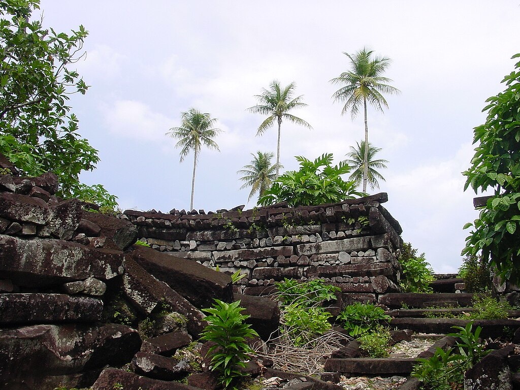
Nan Madol ruins in Pohnpei
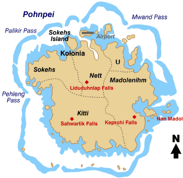
Micronesia is a group of islands in the middle of the Pacific Ocean about 3,200 kilometers east of the Philippines and 3,650 kilometers west of Hawaii. By some reckonings it includes Guam, the Marianas Islands, Palau and the Marshall Islands, but the modern nation of the Federated States of Micronesia (FSM) doesn’t contain them. The main FSM islands are Pohnpei, Kosrae, Chuuk and Yap.
Hundreds of years before the birth of Christ the Chamarro people on Guam and the Marinas Islands quarried massive “latte stones” and used them as foundations for some of their buildings. On the northernmost point of the Palauan island of Babeldaob there are huge basalt monoliths whose origin is a mystery but appear to have been part of huge ceremonial structure that held thousands of people. Virtually nothing is known about the people who laid these stones and terraced the nearby hillsides 2,000 years ago.
The great stone cities of Nan Madol on Pohnpei and Lelu on Kosrae. thrived in the A.D. 8th to 14th centuries, when Europe was adrift in the Dark Ages and the Mayan Civilization was at its zenith. Little is known about them Most of what is known about these ancient cultures has been ascertained from archeological excavations and information gleaned from modern islanders. Early Micronesians had no written language. Knowledge and history was passed on orally from generation to generation.
Nan Madol and Lelu are two of the greatest archaeological sites in the Pacific region. They thrived from A.D. 8th to 14th century. Willaim Lessa wrote: They “were elaborate stonework constructions that functioned as the residence of the leading political authorities and groups of hierarchically ranked priests, and also served as ceremonial centers. [Source: William A. Lessa (1987), Jay Dobbin (2005), Encyclopedia of Religion, Encyclopedia.com]
RELATED ARTICLES:
EARLY HISTORY OF MICRONESIA ioa.factsanddetails.com
PACIFIC ISLAND COUNTRIES AND PEOPLE ioa.factsanddetails.com
FIRST PEOPLE IN OCEANIA AND THE PACIFIC ioa.factsanddetails.com
LAPITA CULTURE AND THE ARRIVAL OF ASIANS IN THE PACIFIC ioa.factsanddetails.com
EXPANSION OF PEOPLE ACROSS THE PACIFIC ioa.factsanddetails.com
Saudeleur Dynasty
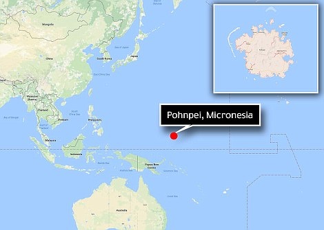
Location of Nan Madol and Pohnpei
Nan Madol on Pohnpei reached its height under the Saudeleurs, a draconian royal dynasty referred as the first organized government of Micronesia. The first of the sixteen Saudeleurs was Olosohpa, one of the builders of Nan Madol. He ruled in the 12th century. [Source: Lonely Planet]
The Saudeleur dynasty was ruled by one man, the Saudeleur, who granted the use of land by the ruling class, who in turn ruled over craftsmen and commoners, who were required to pay tribute to the Saudeleur. The people resented the unwillingness of the Saudeleurs to share their wealth.
Under the Sadelier Sakon Mwehi a single lice in a person’s body was taken to Nan Madol. The favorite delicacy of the Saudeleur Raipwinloko was reportedly human flesh.
Pohnpei was divided into three wehi (states) during the Saudeleur period: Kohpwahlele (madolenihmw), Kohpwahleng (Kitti) and Pwahpwahlik (Sohehs). Later U and Nett became states, making up the present five municipalities of Pohnpei
Isokelekel
The last Saudeleur was conquered by Isokelekel, a semi-legendary figure whose son Nahlepenien was the first Nahhnmwarki of Pohnpei. According to Saudeleur legend, Isokelekel, the son of the Thunder God, was banished to Kosrae for having an affair with the wife of a Saudeleur. Isokelekel heard many stories about the cruel acts of the Saudeleurs when he was young. When he was old enough he took an army of 333 men to Nan Madol and pretended to be friendly visitors, and later attacked. The Saudeleurs fled and were tracked down and killed.
one imagining of Isokelekel
Isokelekel established a new dynasty. He lived and ruled at Nan Madol in the 13th century and was named Nahnmwarki. After his death Pohnpei was divided into five districts, each with its own nahnmwarki.
Nahhnmwarki was known for doing a lot of forbidden things in front of his father: He served fish at the end of spear rather than strung together as he was supposed to do. He climbed onto his father’s canoe from the wrong (outrigger) side, he entered the community house from the front rather the center.
Pohnpei Under Isokekel and Nahnmwarki
Isokekel became the chief of the highest ranking clan, which had power over the clans that ruled Pohnpei's districts. Each district tin turn was ruled by two separate leaders, the primary one from the highest ranking family in the clan and a secondary leader from the second most prominent family. A similar system in still in place. Today, Pohnpei is divided into five districts and each of which has primary and secondary rulers.
Each municipality had tow traditional chieftain lines of rule: nahnmwarki and nahnken. Each lines has 12 positions of rank. The nahnmwarki was considered to be sacred, speaking only to the Nahnken. The Naknken served as intermediary between the nahnmwarki and his people.
Land was owned by the Nhanmwarki. He leased land to the landlords, who oversaw the commoners who worked the land. The commoners were required to present the nhanmwarki with frequent tributes of fruits and fish. These traditions continue today at funerals and celebrations. The Nhanwarki system endures to this day.
Lelu
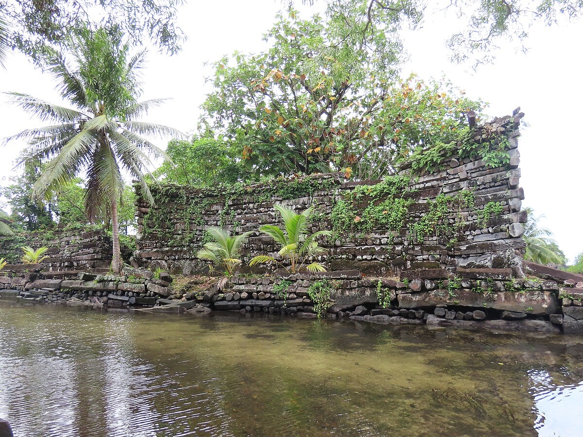
Before the arrival of Europeans, Kosraens lived under a stratified feudal system ruled by a paramount chief who resided in the ancient stone city of Lelu. A group of high chiefs owned the land, a group of lower chiefs managed it, and a peasant class worked the land and built canals and stone buildings. Ordinary people lived on the main island of Kosrae while the chiefs lived in 100 basalt-wall compounds on Lelu. According to old legends, the power of the Kosraen chiefs extended to Pohnpei and Chuuk.
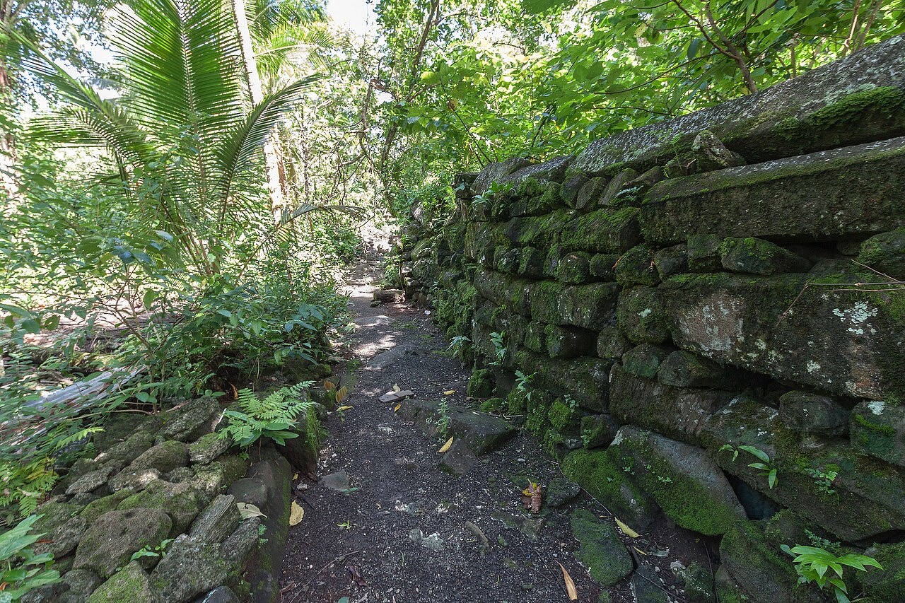
fragment of a wall, Lelu Ruins, Kosrae, Micronesia
According to Archaeology magazine: Like Nan Madol, Leluh contains walls and canals of basalt, but it also has tombs partially built with live coral. Scientists dated coral from the tombs to as early as the 1300s, 300 years older than they had been thought to be. Early establishment of the city suggests a long history as a significant political and economic force in the region and rival to Nan Madol. [Source: Samir S. Patel, Archaeology magazine, July-August 2015]
The Sleeping Lady is the name given to a ridge across Lelu Harbor from Lelu Island. According to legend the ridge was formed from a woman who offended the gods and was placed in the sea in a sleeping position. The women was having her period when the deed was done, which explains why the soil around the ridge is so red. In the old days Kosraean men used to gather the soil to make a red pigment for painting their canoes.
According to legend most people on Chuuk are descendants are a great chief named Sowukachaw who arrived on Chuuk from Kosrae with his son Sowooniiras in the 14th century. These people helped introduce a method preserving breadfruit through fermentation which helps the people to survive droughts and bad harvests.
Lelu Site
Lelu (two miles from Tofol) is an artificial island with the ruins of an ancient city constructed between A.D. 1250 and 1400 on a lowland area made from large stones and coral gravel placed on a reef that extend out from the mainland. The Kosraean head chief and his minor chiefs lived in compound built within huge basalt walls. The compounds and canals once covered the entire area, but many of them were taken down (they only cover about a third of the island today) and the canals have silted up and disappeared. [Source: Lonely Planet]
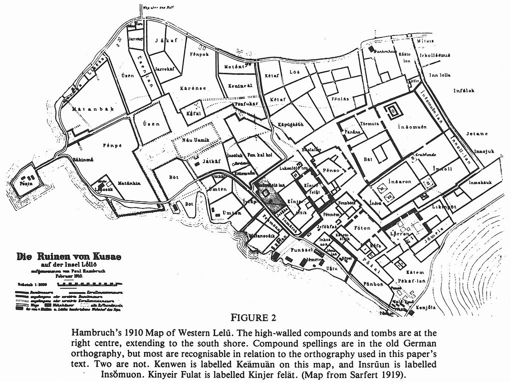
Lelu archaeological map
The island is reached by a causeway. When you first arrive all you see are huts, homes and businesses. The ruins are located in the dense tropical vegetation that lies behind these settlements. A few minutes walk takes you from a sleepy village into overgrown lost city that looks like the kind of place you'd stumble upon Indiana Jones.
The ruins are quite impressive. Many of the compound’s walls are made of hexagonal basalt logs that have been stacked on top of one another like Lincoln logs. The main buildings include the compounds of the high chiefs, sacred compounds, two royal burial mounds and ceremonial houses with pounding stones used in making the narcotic drink sakau.
Kinyeir Fulat is a compound with 20-foot-high basalt walls that are believed to have once contained a meeting house. Nearby in the compounds known as Pensa are walls made of round basalt stones and a feast house used by the high-rankingchiefs. The food preparation compounds contain 20 pounding stones.
Other important sites include Bat, a large dwelling with high basalt walls; Finbata Compound, containing the remains of a large feast house; Lurun, with its interesting basalt log walls; and Insru and Inol, temporary resting places for the high chief before their bones were thrown into the blue hole near Yensar Islet. These sacred areas were forbidden to peasants except for wailing females who watched over the chiefs body while it decomposed.
The Lelu Museum is housed in an old cement warehouse. It contains archeological photos, charts and picture describing Lelu's history and a few old artefacts made from basalt and giant clam shells. You can get can get a nice view of the island and the harbor from the top of Lelu Hill, the highest point on Lelu Island. The hill is filled with caves and tunnels used by the Japanese during World War II. Near the causeway there some good snorkeling sights, a good swimming hole and a aquiculture center where giant clams are raised.
Nan Madol
Nan Madol
Nan Madol (on the southeast side of Pohnpei island about 25 miles by boat from Kolonia) is ancient, mysterious city situated on 92 artificial islets built on tidal flats and the edge of a barrier reef called Sougnahleng ("Reef of Heaven"). Covering about 82 hectares (200 acres, a half square mile), the islets contain the ruins of more than 100 building constructed of hexagonal basalt logs (some over 50 feet long and weighing 50 tons) that are stacked on top of one another log cabin style.
Nan Madol is composed of artificial basalt islands surrounded by canals, and has been called the “Venice of the Pacific”. The amazing prism-shaped basalt logs used to construct the buildings were quarried at another site and carried to Nan Madol by raft. Most likely they were taken from Sokeh's Rock and floated on bamboo to Madolenihmw and rolled or lifted with platforms into place. The logs were also used to construct the islands. They were laid down in the water as retaining walls and then filled in with rock and coral gravel. The water that was retained between the walls became part of sophisticated network of canals that were used like roads for people to get from place to place.
According to Archaeology magazine: Nan Madol was one of the first in Oceania to be ruled by a chief. Using uranium-thorium dating, researchers found that construction of a monumental tomb, the size of a football field, began there in 1180 and was completed by 1200. This pushes back the establishment of the capital and its chiefdom by 100 years. [Source: Samir S. Patel, Archaeology magazine, January-February 2017]
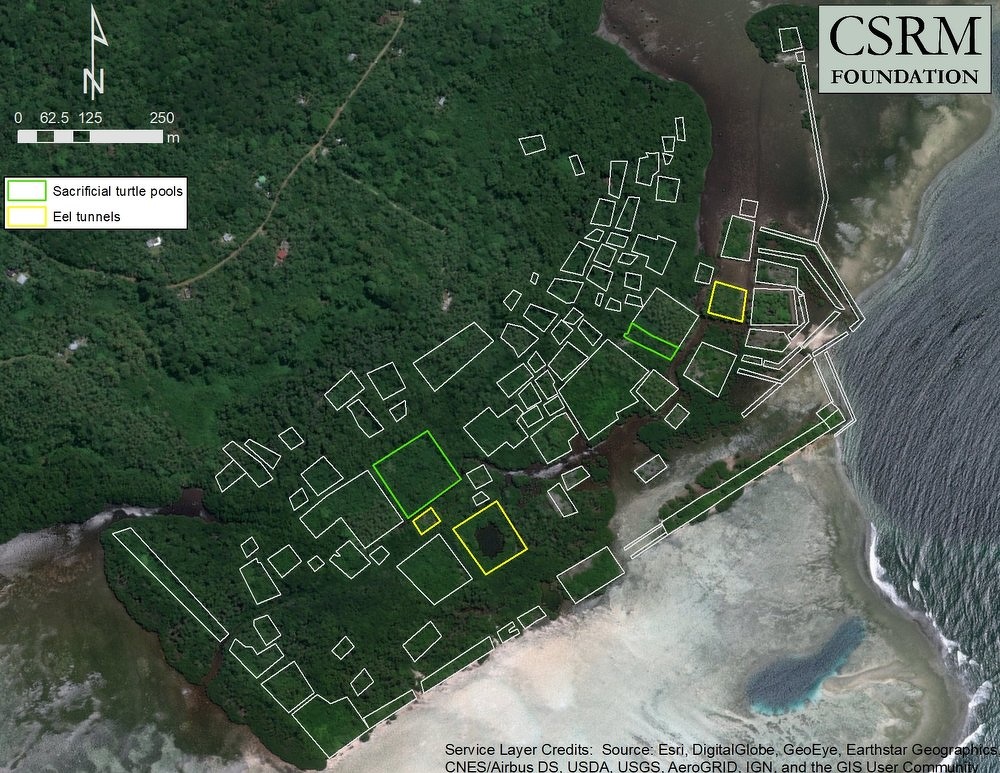
Nan Madol is divided into two parts: Madol Power ("Upper Madol") and Madol Pay ("Lower Madol"). The eastern half, Madol Power, was primarily a religious center with special compounds where rituals were performed. The western half, Madol Pay, was primarily an administrative area. Each islet was the site of one or more activities. The structures on the islets includes temples, burial chambers, meeting houses, bathing areas and pools that held turtles, fish and eels. The difficulty of access (only at high tide) was probably for military seasons.
History of Nan Madol
Pohnpei under Saudeleur rule
Nan Madol means "Places in Between." a reference to islands between numerous waterways and canals. According to legend the initial construction was carried out by two brothers: Ohlpsohpa and Ohlosihpa. They arrived from islands to the west on a fleet of canoes and established an administrative system and "sacred ceremony" on Pohnpei. The chose the location at Sounahkeng with the help of the Gods and enlisted the help of local people and magical powers to raise the buildings on different areas called “wehis” ("turtle states").
The first building were constructed around A.D. 500. Most of megalithic buildings were constructed during the Saudeleur period between A.D. 1100 and 1400, according to legend as a mirror image of a sunken city on the legendary lost continent of Mu which could still be seen when the city was constructed. As nothing grew on the coral ruble that was the foundation of Nan madol, the Saudeleurs arranged for food to be brought in from the main island as a tribute
When Europeans arrived in the 1820 the city was abandoned but old people at time recalled when it was still inhabited. Why it was abandoned is still a mystery.
Nan Madol is still sacred to Pohnpeians and some Pohnpeians are not comfortable visiting Nan Madol. They feel that the souls of the cruel Saudeleur chiefs should be left to rest in peace. In 1907 a German governor died of a mysterious illness immediately after excavating a burial tomb. The cause of death was listed as heat exhaustion but many local believe it was the work of disturbed spirits. Archaeological excavation of Nan Madol began in 1899. The Smithsonian conducted research at the site beginning in 1963.
The best time to visit Nan Madop is during high tide. During low tide some of the tidal flats are exposed and boats have difficulty getting through some of the canals. Trips are scheduled according the tides. You can also get to Nan Madol by car or van. You can either drive to near the site and then take a boat, or you can take a boat from Kolonia. Most people make arrangements with a tour operator. Boat and overland tours to Nam Madol from Kolonia cost around $50 to $75 and include stops at waterfalls.
Buildings at Nan Madol
Nan Douwas is the most impressive structure at Nan Madol. It is a large compound and the main fortress, with 7.6-meter (25-foot) -high outer walls and an inner compound surrounding burial chambers containing the remains of the Saudeleur kings. The largest tomb contains a rectangular crypt covered by 5,5-meter (18-foot)-long, one-ton basalt stones. A deep hole in the inner wall was used to hold prisoners.
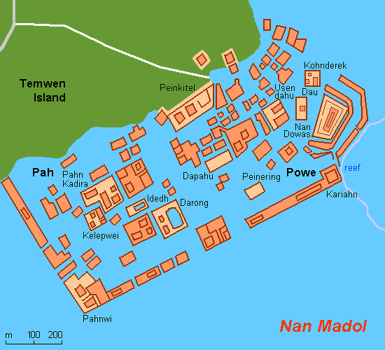
Nan Douwas means "in the mouth of the high chief." Important meetings and prayer sessions to the great spirit Nahnishnsapw took place here. The island is composed of 13,5000 cubic meters of coral fill and 4,500 cubic meters of basalt. Construction of the islet began around 800 years ago. Cooking stones can still be found here. Kariahn islet also has a high wall enclosing a crypt.
Nan Mwolehsei is the island near the ocean entrance. Its name means "where the voyage stops." It contains a gate at the only ocean entrance to Nan Madol and a wall that held back waves and currents. According to legend the gate was guarded by two sharks and people who jumped from a particular section of the wall earned good luck.
Pahnwi is a 20,000 cubic meter island with an elevation of 8 meters. Built beginning in 1250, it houses tombs, house platforms and a seawall of monoliths.. During Saudeleur times it was a docking area for canoes, A large bolder at the center of the southwest wall was reportedly rubbed by the stomachs of pregnant women to ensure an easy childbirth. Archaeologists have unearthed beads, ornamental pendants, perorfmaraed etehc and human bones here.
Wasau was where food was prepared. Dating back to A.D. 600 and covering s half an acre, it features residential platforms and mounds. Dapahu dates back to A.D. 232. It was a multi functional island where cooking, canoe making and woodworking took place.
Government Buildings at Nan Madol
Pahn Kadira was an administrative area that contains the platform of the temple of the Thunder God. Initially built in the 9th century and enlarged significantly in the 14th and 15th century, it lies at the center of the Saudeleur residential area and was the site of important rituals and meetings and where royal decisions were made. In old legends the island was often referred to as "under the baoo" or "the forbidden city" because of its important and off limits status. Near the main entrance is a stone where warriors left their spears.
Kelepwei was a residential islet for servants and visitors of the Saudeleurs. Among those who stayed here were Isohkelekel and 333 warriors. Dau is the home of the warrior class. No women were allowed on the island. A subsurface tunnel is believed to have been the home of a sacred eel used in special ceremonies.
Nan Madol transposed on modern Google Maps shot
Peikapw is an island with pools for turtles. In one pool Isohkelekel reportedly saw himself as an old man and killed himself. Another pool was believed to have magical powers and was reportedly used by the Saudeleurs to observe events in far away places. Two large stones and two trees are said to be four women who forgot to pay their tributes and were thus transformed.
Religious Buildings at Nan Madol
William Lessa wrote: Kosrae had a centralized chief or king, the tokosra, and several priesthoods, each dedicated to a leading deity such as Sinlanka. Some priests stayed in the ritual and political center of Lelu at Kosrae. Others lived at shrines scattered across the island, and on certain occasions these rural priests led processions into Lelu. One of the most important rituals they led celebrated the coronation of the king and his queen. [Source: William A. Lessa (1987), Jay Dobbin (2005), Encyclopedia of Religion, Encyclopedia.com]
Nan Madol was the residence of the leading chief of the Sau Deleur dynasty with a section for the attending priesthoods. Next to the Sau Deleur residence and court was the tiny islet of Idet, where a turtle was sacrificed to a sacred moray eel. To what extent Nan Madol controlled all of Pohnpei is debatable, but other ritual centers with priest-chiefs continued to exist as independent entities.
Idet was the main religious center of Nan Madol. Every year a two-week religious ceremony was held here which included sakau drinking, feasting, outrigger canoe racing and a ceremony in which cooked turtle was offered to Nan Sahwohl (the "holy eel"). The eel was regarded by the Sadeleurs as a medium between the people and the gods. On the islet are 333 magic stones believed to have been brought by Isokelekel's 333 warriors for protection in battle.
Usendau was the residential area for the priests during the Saudeleur era and the site for the Nhanmwarkis after the fall of the Saudeleurs. The islet was built between A.D. 750 and 900 and is 70 by 80 meters in size. There is a traditional U-shaped meeting house on the island built in the 19th century.
Kohnderek is where funeral sakau drinking rituals took place. Upon death, residents of Nan Madol were perfumed with coconut oil, flowers and fish bones and rolled in a mat with personal belongings and taken from islet to islet before stopping here to be honored with dancing and sakau drinking in the U-shaped meeting house. Afterwards burial took place on different islets depending on the status of the deceased.
Darong is an island with a large stone used in sakau making rituals and nearby reef used to raise clams. It was constructed around a natural reef pool measuring 70 by 56 meters where ceremonial clam fishing took place using coconut leaves as bait. Running through the island are 11 tunnellike channels believed to be used to hold sacred eels and allow water to come in with the high tide. A sakau pounding stone weighs two tons.
Grand Rituals at Nan Madol and Lelu
William Lessa wrote: The turtle–eel ceremony may have been the culmination of a longer, more ancient ritual. Its symbolism is debated. Rufino Mauricio, a Pohnpeian archaeologist and specialist in oral histories, has suggested that the Nan Madol ritual combines an older ritual focused on sacred sites with newer rituals worshipping living animals like the eel. Another interpretation focuses on the meaning of wehi, the turtle, which is also the name for the main sections of Pohnpei, and says that three wehis sacrificed their independence and autonomy to the ravenous appetite of the Sau Deleur dynasty. [Source: William A. Lessa (1987), Jay Dobbin (2005), Encyclopedia of Religion, Encyclopedia.com]
Neither interpretation is compelling, especially since the ritual outlived the fall of the Sau Deleurs and then was stopped by one of the paramount chiefs (nahnmwarki ) of the Nan Madol area after a priest killed the eels because he did not get his share of the turtle meat. After about 1860 the priesthoods disappeared along with the animal sacrifices. Nan Madol is now abandoned, a monument to the Pohnpeian fear of centralization.
The political structure after the fall of the Sau Deleurs mirrors a shift in the evolution of Pohnpeian religion. One or two priestly centers of worship predate Nan Madol and the Sau Deleur dynasty, with a high priest who also was the political chief of the area. At least one of these the high priests and chiefs, the soukisenleng (literally "the master of the part of heaven"), eventually joined the post-Sau Deleur structure of autonomous, paramount chiefs (nahnmwarkis ) and took or was given the highest title of nahnmwarki. His priests took lesser noble titles. The ruler or nahnmwarki of the southern wehi of Wene is still called the soukisenleng, and the other nobles of Wene still have the old priestly titles. Mauricio judges this shift to be an early form of secularization. Of the priesthoods only the titles remain, although it is not known when they lost their religious functions.
Some elements of the old priestly rituals are maintained in the ceremonial houses (nahs ) of the nahnmwarkis. Ritual offerings of sakau (kava, Piper methysticum ) are made to the god as they were in days of old. Sakau offering is part of a formal reconciliation ritual led by the chiefs; it is now incorporated into the Roman Catholic sacrament of forgiveness. In modern times sakau, which is made into a slightly narcotic drink, has been secularized, and can be enjoyed in sakau bars.
Image Sources: Wikimedia Commons
Text Sources: Lonely Planet Guides William A. Lessa (1987), Jay Dobbin (2005), Encyclopedia of Religion, Encyclopedia.com; “Encyclopedia of World Cultures, Volume 2: Oceania,” edited by Terence E. Hays, 1991, Wikipedia, Encyclopedia.com, New York Times, Washington Post, Los Angeles Times, Library of Congress, National Geographic, Smithsonian magazine, The New Yorker, Reuters, Associated Press, AFP, BBC, CNN, and various books, websites and other publications.
Last updated October 2025