Home | Category: History and Exploration / History and Religion / History and Religion / History and Religion / History and Religion / History and Religion
EXPANSION OF PEOPLE ACROSS THE PACIFIC
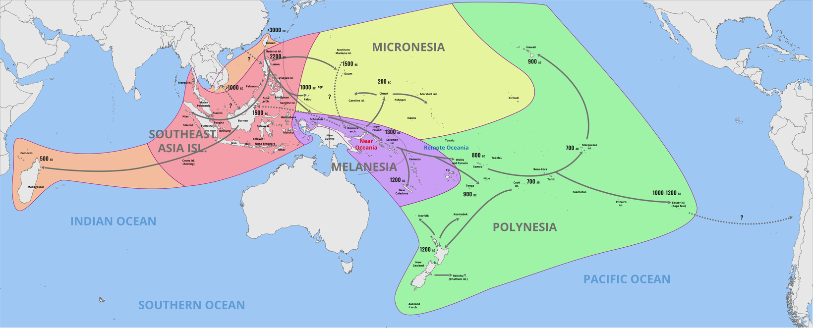
About 3000 B.C. speakers of the Austronesian languages, probably from Taiwan (Formosa), mastered the art of long-distance canoe travel and spread themselves, or their languages, south to the Philippines and Melanesia and east to the islands of Micronesia. The Polynesians branched off and occupied Polynesian Triangle to the east.
Some have theorized that these people traveled first to the Philippines and Indonesia. Then they made it the coast and islands of New Guinea. After that they moved eastward towards Fiji and the Pacific islands in that area and westward to Madagascar. The last place to be reached were New Zealand, Hawaii and Easter Island.
Ancient Polynesians used double-hulled sailing canoes to cover vast. distances. By A.D. 1300 they had settled more than 10 million square miles of the Pacific Ocean roughly between New Zealand, Hawaii and Easter Island. The Polynesians relied on sun, stars and birds for navigation and periodic but predictable winds to transport them across vast stretches of open sea.
The Hokule'a, a traditional voyage canoe, made the 14,400-kilometer (9,000-mile) round trip between Hawaii and Easter Island. Navigator Nainoa Thompson told National Geographic, "Our ancestors had to know the ocean intimately. Mistakes could be fatal.
RELATED ARTICLES:
PACIFIC ISLAND COUNTRIES AND PEOPLE ioa.factsanddetails.com
FIRST PEOPLE IN OCEANIA AND THE PACIFIC ioa.factsanddetails.com
AUSTRONESIAN PEOPLE OF OCEANIA, INDONESIA, MALAYSIA, TAIWAN AND THE PHILIPPINES: ORIGIN, HISTORY, EXPANSION ioa.factsanddetails.com
LAPITA CULTURE AND THE ARRIVAL OF ASIANS IN THE PACIFIC ioa.factsanddetails.com
NAN MADOL, LELU AND THE GRAND CIVILIZATIONS OF MICRONESIA ioa.factsanddetails.com
Timing of the Expansion of People Across the Pacific
Dates and routes are uncertain, but they seem to have started from the Bismarck Archipelago, went east past Fiji to Samoa and Tonga about 1500 B.C.. By A.D. 100 they were in the Marquesas Islands and A.D. 300-800 in Tahiti, west of the Marquesas. Between A.D. 300-800 are also given as the time of arrival of people in Easter Island, their easternmost point, and Hawaii, which is far to the north and distant from other islands. Far to the southwest, New Zealand was reached about A.D. 1250. The Chatham Islands, about 500 miles east of New Zealand were reached about 1500. [Source: Wikipedia]

direction of the Austronesian expansion from Taiwan into the Pacific; PNAS 112/44 Matisoo-Smith et al, CC BY-ND
Terence E. Hays wrote in the “Encyclopedia of World Cultures”: “Both during and after the Lapita period, further expansion into Remote Oceania continued with the Pacific serving less as a barrier than as a highway. The Cook Islands, the Society Islands, and the Tuamotu Archipelago were settled by about 2,500 Years ago; the Marquesas Islands and remote volcanic islands such as Rapa, within the next 500 years; and, remotest of all, Easter Island, by 1,500 Years ago [Source:“Encyclopedia of World Cultures, Volume 2: Oceania,” edited by Terence E. Hays, 1991 |~|]
Not all movements were in a simple easterly direction, however. By 1,500 Years ago, people (probably from the Marquesas) had settled in the Hawaiian chain and it is likely that the Fiji-Samoa-Tonga *triangle" was a major staging area for movements to the southwest (reaching New Zealand by about 1,000 Years ago) and northwestward into the Ellice Islands (Tuvalu), the Gilbert Islands, the Marshalls, and the Carolines during the period from 2,000 to 1,500 Years ago New immigrants also continued to enter Oceania, with groups originating in Indonesia and the Philippines first settling areas such as Belau and Yap.
How People Got to the Pacific Islands
According to the “Encyclopedia of World Cultures”: “To get a general idea of how” people got to the islands of the Pacific Ocean, we might follow some scholars and divide the Pacific into Near Oceania and Remote Oceania. Near Oceania includes the islands of the western Pacific from Australia and New Guinea eastward to the end of the Solomon Islands. As mentioned previously, these islands tend to be relatively large and are fairly close together, often grouped in clusters (or archipelagoes) within which at least some islands are mutually visible under clear conditions. In the remainder of the Pacific, the islands of Remote Oceania are separated from Near Oceania by at least 350-kilometer gaps of open ocean, and many archipelagoes are 1,000 kilometers or more from their nearest inhabited neighbors. All available evidence indicates that Near Oceania was initially settled by people tens of thousands of years before anyone ventured into Remote Oceania, or at least before they left behind any evidence of their presence there. [Source:“Encyclopedia of World Cultures, Volume 2: Oceania,” edited by Terence E. Hays, 1991 |~|]

distribution of the Austronesian languages and primary subdivisions
“Relative nearness to Asia and its large southeastern islands-where the human lineage goes back in time at least a million years-is only one of the conditions that favored the earlier settlement of Near Oceania. Many of the details of the settlement of Oceania are not yet known, and most of those we do know cannot b included in a brief outline such as that offered here. Moreover, there is much that we will never be able to know for sure since the original inhabitants of the Pacific islands-like their descendants today-were the agents of tremendous changes in the islands themselves, thereby complicating the tasks of historical reconstruction. The introduction of new plants and animals, deforestation through fire and land-clearing activities, and the depletion and extinction of many natural species began to alter the Pacific landscapes from the beginning. |~|
“What we can say with some certainty is that the Pacific was colonized over a long period of time, at many different periods in time (with some places settled much more recently than others), probably for many different reasons (including both accidental and purposeful ventures), and by many different groups of people, who varied among themselves in physical types, languages, and cultures. Much of this diversity has been subsequently enhanced and redirected through both mixing and isolating of populations and as a result of local adaptations to circumstances that were themselves highly diverse. |~|
Boats That Allowed the First People in Oceania to Migrate
The boats that allowed the first people of the Pacific to explore the vast stretches of open ocean, wrote Dobbs in National Geographic, were ships, really: long canoes with sails, outriggers, and far greater speed and range. They allowed the Austronesians to sail in high winds and higher seas. These craft must have stunned the locals. The excitement the ships created, traceable today in the Polynesian culture and the longevity of its marine vocabulary, would have conferred great status. The motivation to explore increases, as does the reward. Like today’s astronauts, the Pacific Island boatbuilders and sailors would have enjoyed a social cachet that enhanced mating opportunities, commanded social and economic support, and created a motivating force that might coddle any number of restless genes. As anthropologist and National Geographic Explorer-in-Residence Wade Davis puts it, “When you set sail to find new lands, you became mythologized — even if you didn’t come back.” And so Tupaia, riding in the DNA of his ancestors, headed east.||

Melanesian catamaran from Fiji
“A proper sailing craft like the ship the Polynesians developed makes a near-perfect metaphor for the larger powers we gain through culture. It gives our malleable genomes, imaginative minds, and clever hands the power to transform even the strongest forces in our environment — wind, water, current — from threat to opportunity. Let the wind rise to a howl and raise a great sea; we needn’t stay home or become flotsam, for we can change tack, trim sail, and become what amounts to a different vessel. To the Lapita looking out from the eastern tip of the Solomons, a vast ocean before them, such a boat would offer something like a new set of legs. Tiller in hand and new isles in their minds, they could press on in their journey around the globe. ||
“It’s enough to move even a Max Planck geneticist. Ana Duggan, telling me of these boats in Leipzig, confessed she was by nature not the sailing type. But this bigger boat we were talking about — just the idea of that boat — seemed to rouse her inner mariner. “If someone pulled up to shore in one of those and said, ‘Look at my big fancy boat. I can go far,’ ” she mused, “I’d get in.”
Polynesian Navigation Skill
Sometimes referred to as "Vikings of the Sunrise," the ancient Polynesians landed on almost every habitable island in the South Pacific before A.D. 1000 and navigated an area between Southeast Asia in the west, Hawaii in the north, Easter Island to the east and New Zealand to the south. Their navigational feats far excelled those of Christopher Columbus. The first Polynesians lived by fishing and cultivating root and tree crops such as breadfruit, taro and yams, and were known for their elaborate system of navigation.
Polynesians used simple dugout canoes to get around protected waters in the lagoons that surrounded their home islands and canoes with a single outrigger to navigate the open ocean. Small outrigger canoes were made from a single breadfruit tree trunk hollowed and carved with simple hand tools. Large canoes, sometimes over a 100 feet long, were constructed of planks tied together with coconut-fibre rope. Larger and faster than the ships used by European explorers, these canoes carried up to a hundred men and supplies to keep them going for months at sea.

The hand method used by Nainoa Thompson to find the altitude of the Polaris, Journal of the Polynesian Society
Without compasses and maps, Polynesians navigated their way across thousands of miles of open ocean, where they relied primarily on celestial navigation. Since they traveled mainly in east-west lines, they set their course based on the position of the sun and the rising and setting positions of certain stars which were associated with specific islands. To head north and south they followed the North Star and the Southern Cross. Knowledge of directions, and important stars and island positions were passed from generation to generation in the form of chants.
Polynesians also navigated using knowledge of winds and waves patterns and currents caused by the deflection and movement of ocean water around islands. Distant atolls, for example, could be located because they broke up the large swells that move east to west across the Pacific Ocean.
Land was located by watching the birds (who usually returned to their island nests at night) and cloud patterns. Single stationary clouds, for example, usually formed around large islands. In some cases, pale green light that reflected from an atoll's shallow lagoon could be seen on the underside of clouds.
Marshall Islands Stick Charts
Marshall Islanders have long been skilled navigators, employing celestial navigation systems similar to those used throughout Micronesia, as well as distinctive stick charts to map wave patterns, shapes and changes, which were used by Marshallese navigators to travel throughout the island chains.

stick chart from the Marshall Islands
In travels between the islands, early inhabitants learned to read the patterns of the waves and the positions of the stars, and they made stick charts to record and pass on their observations to less-experienced navigators. By tying flat strips of wood together with coconut twine in imitation of the wave patterns and attaching cowrie shells to the sticks to represent particular islands and atolls, the experienced navigator could memorize the patterns for when he was out at sea the charts were not actually taken on the journeys.
Navigational maps, commonly known as "stick charts," were originally used in the Marshall Islands by navigators during long ocean voyages. Although stylized, the charts were functional objects providing information on the locations of individual islands as well as wave patterns.
Stick charts were used by ancient sailing masters to pass on their secret knowledge to the younger generation. The information on the stickcharts was memorized and the charts themselves were never taken on journeys. Stick charts were still in use as late as the 1950s. Although few people remember how to read the charts, the theory is still taught today and charts are made as souvenirs.
See Separate Article MARSHALL ISLANDS EARLY HISTORY ioa.factsanddetails.com
Sweet Potato Origins and Pacific People Migrations
It was originally thought that they potatoes were carried to the islands of the Pacific where they are popular today from the Americas by humans centuries before the arrival of Columbus. Since it seem unlikely the seeds floated across the Pacific it is believed that pre-Columbian men in boats, either from the Americas or the Pacific, carried them there. Thor Heyerdahl's Kon-Tiki expedition successfully demonstrated that the trip from the Americas to Polynesia using only materials and technology available at the time was at least possible, even if highly improbable. [Source: New York Times, Wikipedia]
Carl Zimmer wrote in the New York Times:“Of all the plants that humanity has turned into crops, none is more puzzling than the sweet potato. Indigenous people of Central and South America grew it on farms for generations, and Europeans discovered it when Christopher Columbus arrived in the Caribbean. In the 18th century, however, Captain Cook stumbled across sweet potatoes again — over 4,000 miles away, on remote Polynesian islands. European explorers later found them elsewhere in the Pacific, from Hawaii to New Guinea. The distribution of the plant baffled scientists. How could sweet potatoes arise from a wild ancestor and then wind up scattered across such a wide range? Was it possible that unknown explorers carried it from South America to countless Pacific islands? [Source: Carl Zimmer, New York Times, April 12, 2018]
Scientists have offered a number of theories to explain the wide distribution of I. batatas. Some scholars proposed that all sweet potatoes originated in the Americas, and that after Columbus’s voyage, they were spread by Europeans to colonies such as the Philippines. Pacific Islanders acquired the crops from there.As it turned out, though, Pacific Islanders had been growing the crop for generations by the time Europeans showed up. On one Polynesian island, archaeologists have found sweet potato remains dating back over 700 years. [Source: Carl Zimmer, New York Times, April 12, 2018]
A radically different hypothesis emerged: Pacific Islanders, masters of open-ocean navigation, picked up sweet potatoes by voyaging to the Americas, long before Columbus’s arrival there. The evidence included a suggestive coincidence: In Peru, some indigenous people call the sweet potato cumara. In New Zealand, it’s kumara. A potential link between South America and the Pacific was the inspiration for Thor Heyerdahl’s famous 1947 voyage aboard the Kon-Tiki. He built a raft, which he then successfully sailed from Peru to the Easter Islands.
Genetic evidence only complicated the picture. Examining the plant’s DNA, some researchers concluded that sweet potatoes arose only once from a wild ancestor, while other studies indicated that it happened at two different points in history. According to the latter studies, South Americans domesticated sweet potatoes, which were then acquired by Polynesians. Central Americans domesticated a second variety that later was picked up by Europeans.
Hoping to shed light on the mystery, a team of researchers recently undertook a new study — the biggest survey of sweet potato DNA yet. And they came to a very different conclusion. “We find very clear evidence that sweet potatoes could arrive in the Pacific by natural means,” said Pablo Muñoz-Rodríguez, a botanist at the University of Oxford. He believes the wild plants traveled thousands of miles across the Pacific without any help from humans. Mr. Muñoz-Rodríguez and his colleagues visited museums and herbariums around the world to take samples of sweet potato varieties and wild relatives. The researchers used powerful DNA-sequencing technology to gather more genetic material from the plants than possible in earlier studies.
See Separate Article TUBERS AND ROOT CROPS: SWEET POTATOES, CASSAVA AND YAMS factsanddetails.com
First People in Madagascar
Madagascar is one the last places to be inhabited by man. Aborigines arrived on Australia 65,000 years ago; the ancestors of American Indians crossed the Bering Strait, perhaps 35,000 years ago; but as far as anybody can tell no one arrived on Madagascar until about A.D. 500. Other than small islands, New Zealand was the only place settled later.
The early inhabitants of Madagascar mostly were Malay-Polynesians who arrived on outriggers by following the South Equatorial Current. In August 1994, a 32-foot fishing boat slipped from its mooring in Western Australia and washed up near Madagascar seven months later in Xai-Xai Madagascar. Oceanographers believe that boat was carried by the South Equatorial Current at a rate of about 20 miles a day.
Why would people migrate 4,000 miles across an open sea to Madagascar? Some people speculate that the island where they lived became crowded or they got lost...In terms of bravery certainly as incredible as what Columbus did. Within a century the first humans in Madagascar hunted giant lemurs to extinction. With no natural predator the large, probably slow moving, creatures were unafraid of men and easy to kill. People exterminated giant land tortoises and pygmy hippos. [Source: "Endangered People" by Art Davidson]
Large numbers of Indonesian-Malays are believed to have arrived in the 9th century when the powerful Hindu-Sumatran Srivijaya Empire controlled much of the Indian Ocean. They brought their many of their customs, rice and agricultural methods with them. Arabs on dhows came around the 11th century. No one is sure when the first Africans came.
Unlike Madagascar, Mauritius has not settled by Malay that drifted across the Indian Ocean from what is now Indonesia and Malaysia. Arab traders and Malay mariners visited present-day Mauritius in the early Middle Ages but did not settle there.
Image Sources: Wikimedia Commons
Text Sources: “Encyclopedia of World Cultures, Volume 2: Oceania,” edited by Terence E. Hays, 1991, Wikipedia, New York Times, Washington Post, Los Angeles Times, Times of London, Lonely Planet Guides, Library of Congress, The Guardian, National Geographic, Smithsonian magazine, The New Yorker, Reuters, Associated Press, AFP, BBC, CNN, and various books, websites and other publications.
Last updated October 2025