Home | Category: Physical Oceanography
THEORY OF OCEAN TIDES
According to the “Introduction to Physical Oceanography”: Mariners have known for at least four thousand years that tides are related to the phase of the moon. The exact relationship, however, is hidden behind many complicating factors, and some of the greatest scientific minds of the last four centuries worked to understand, calculate, and predict tides. Galileo, Descartes, Kepler, Newton, Euler, Bernoulli, Kant, Laplace, Airy, Lord Kelvin, Jeffreys, Munk and many others contributed. Some of the first computers were developed to compute and predict tides. Ferrel built a tide-predicting machine in 1880 that was used by the U.S. Coast Survey to predict nineteen tidal constituents. In 1901, Harris extended the capacity to 37 constituents. [Source: Robert Stewart, “Introduction to Physical Oceanography”, Texas A&M University, 2008]
Despite all this work important questions remained: What is the amplitude and phase of the tides at any place on the ocean or along the coast? What is the speed and direction of tidal currents? What is the shape of the tides on the ocean? Where is tidal energy dissipated? Finding answers to these simple questions is difficult, and the first, accurate, global maps of deep-sea tides were only published in 1994 (LeProvost et al. 1994). The problem is hard because the tides are a self-gravitating, near-resonant, sloshing of water in a rotating, elastic, ocean basin with ridges, mountains, and submarine basins.
Earth’s crust is elastic. It bends under the influence of the tidal potential. It also bends under the weight of oceanic tides. As a result, the sea floor, and the continents move up and down by about 10 centimeters in response to the tides. The deformation of the solid earth influence almost all precise geodetic measurements.
Oceanic tides lag behind the tide-generating potential. This produces forces that transfer angular momentum between earth and the tide producing body, especially the moon. As a result of tidal forces, earth’s rotation about it’s axis slows, increasing the length of day; the rotation of the moon about earth slows, causing the moon to move slowly away from earth; and moon’s rotation about it’s axis slows, causing the moon to keep the same side facing earth as the moon rotates about earth.
Note that many oceanographic books state that the tide is produced by two processes: 1) the centripetal acceleration at earth’s surface as the earth and moon circle around a common center of mass, and 2) the gravitational attraction of mass on earth and the moon. However, the derivation of the tidal potential does not involve centripetal acceleration, and the concept is not used by the astronomical or geodetic communities.
Related Articles:
OCEAN TIDES: TYPES, TERMS, FORCES ioa.factsanddetails.com
OCEANOGRAPHY AND STUDYING THE SEA ioa.factsanddetails.com
PHYSICS OF THE OCEAN: PRESSURE, SOUND AND LIGHT ioa.factsanddetails.com
PHYSICAL FEATURES OF THE OCEAN FLOOR: TRENCHES, VENTS, MOUNTAINS ioa.factsanddetails.com
WAVES IN THE OCEAN: TYPES, CAUSES, AND EFFORTS TO DESCRIBE, PREDICT AND MEASURE THEM ioa.factsanddetails.com
OCEAN CURRENTS: FORCES, CONCEPTS, TYPES, MAPS ioa.factsanddetails.com
Websites and Resources: National Oceanic and Atmospheric Administration (NOAA) noaa.gov; “Introduction to Physical Oceanography” by Robert Stewart , Texas A&M University, 2008 uv.es/hegigui/Kasper ; Woods Hole Oceanographic Institute whoi.edu ; Cousteau Society cousteau.org ; Monterey Bay Aquarium montereybayaquarium.org
RECOMMENDED BOOKS:
“Tides: The Science and Spirit of the Ocean” by Jonathan White Amazon.com
“Waves, Tides and Shallow-Water Processes” Open University(1989) Amazon.com
“Ocean Currents: Physical Drivers in a Changing World” by Robert Marsh, Erik van Sebille Amazon.com
“Ocean Currents and Their Effects on the Global Climate System” by Alexander Moreau (2025) Amazon.com
“Gulf Stream Chronicles: A Naturalist Explores Life in an Ocean River” by David S. Lee and Leo Schleicher (Illustrator) Amazon.com
“The Gulf Stream: Encounters With the Blue God” by William MacLeish(1989) Amazon.com
“Ocean Circulation” Open University(2001) Amazon.com
“Adrift: The Curious Tale of the Lego Lost at Sea” by Tracey Williams (2022) Amazon.com
“The Wave: In Pursuit of the Rogues, Freaks, and Giants of the Ocean” by Susan Casey (2010) Amazon.com
“Waves in Oceanic and Coastal Waters” by Leo H. Holthuijsen (2007) Amazon.com
“Descriptive Physical Oceanography” by Lynne Talley (2017) Amazon.com
“Essentials of Oceanography” by Alam Trujillo and Harold Thurman Amazon.com
“The Blue Machine: How the Ocean Works” by Helen Czerski, explains how the ocean influences our world and how it functions. Amazon.com
“How the Ocean Works: An Introduction to Oceanography” by Mark Denny (2008) Amazon.com
“The Science of the Ocean: The Secrets of the Seas Revealed” by DK (2020) Amazon.com
“Atmospheric and Oceanic Fluid Dynamics: Fundamentals and Large-Scale Circulation” by Geoffrey K. Vallis (2006) Amazon.com
“The Unnatural History of the Sea” by Callum Roberts (Island Press (2009) Amazon.com
“Ocean: The World's Last Wilderness Revealed” by Robert Dinwiddie , Philip Eales, et al. (2008) Amazon.com
“Blue Hope: Exploring and Caring for Earth's Magnificent Ocean” by Sylvia Earle (2014) Amazon.com
“National Geographic Ocean: A Global Odyssey” by Sylvia Earle (2021) Amazon.com
Are Tides Higher When the Moon Is Directly Overhead?
High tides do not coincide with the location of the moon. While the moon and sun cause tides on our planet, the gravitational pull of these celestial bodies does not dictate when high or low tides occur. [Source: NOAA]
Tides originate in the ocean and progress toward the coastlines, where they appear as the regular rise and fall of the sea surface. Thanks to Sir Isaac Newton’s 1687 discovery, we know that tides are very long-period waves that move through the ocean in response to forces exerted by the moon and sun. However, these gravitational forces do not control when high or low tide events occur. Other forces, more regional than the moon or sun, control the tides. Many of them have to do with the geography and shape of the Earth.
The shape of our planet has a lot to do with differences in gravitational pull at various locations. If Earth was a true sphere covered by an ocean of constant depth, then it would be true that a high tide event would occur at the location with the moon overhead. The tidal "bulge" would move around the Earth with the moon, but this is not the case with our planet. The Earth is not a true sphere, but bulges slightly at the Equator. It is also dotted with large land masses (continents). Areas where the Earth’s surface is higher, such as mountains, have a stronger gravitational force than do places where the surface is lower, such as a valley or cavern. At the same time, the depth of the world ocean varies greatly. All of these factors play into the height of the tides.
Another thing to consider when thinking about tides is the dimension of time. There are lags in time when an observer experiences high or low tide, and the lag varies from one location to another. For example, the rising slope of the ocean floor approaching the U.S. East (known as the continental rise, continental slope, and continental shelf) slows down the tidal "bulge" or "wave" of water. The lag can be hours or even close to an entire day in some parts of the world. Think of the wave or bulge that you see when you throw a rock into a pond. The wave travels outward in a ring. If there is a tree or other obstruction in the pond, the ring of waves would travel and wrap around it. The same holds true for the tides.
Do Big Lakes and Inland Seas Have Tides?
Water levels in big lakes and inland seas change primarily because of meteorological effects. True tides — changes in water level caused by the gravitational forces of the sun and moon — do occur in a semi-diurnal (twice daily) pattern on big lakes such as the Great Lakes in the United States . Studies indicate that the Great Lakes spring tide, the largest tides caused by the combined forces of the sun and moon, is less than five centimeters in height. These minor variations are masked by the greater fluctuations in lake levels produced by wind and barometric pressure changes. Consequently, the Great Lakes are considered to be non-tidal.[Source: NOAA]
Water levels in big lakes and inland seas have long-term, annual, and short-term variations. Long-term variations depend on precipitation and water storage over many years. Annual variations occur with the changing seasons. There is an annual high in the late spring and low in the winter. These changes occur at a rate that can be measured in feet per month.
Wind and weather conditions on the Great Lakes may create a seiche, an oscillating wave which can be several feet high. In many of the Great Lakes, the time period between the “high” and “low” of a seiche may be between four and seven hours. As this is very similar to the six-hour time period of the tides on the ocean, it is frequently mistaken for a tide.
Studying and Monitoring Tides
We study tides for safe navigation, recreation, and coastal development. Scientists measure the times, heights, and extents of both the rise and fall of the tidal waters that support a number of different aspects of our daily lives. Navigating ships safely through shallow water ports, intracoastal waterways, and estuaries requires knowledge of the time and height of the tides as well as the speed and direction of the tidal currents. Mariners need accurate data because the depths and widths of the channels along with increased marine traffic leaves very little room for error. [Source: NOAA]
Engineers need data to monitor fluctuating tide levels for harbor engineering projects such as the construction of bridges and docks. Projects involving the construction, demolition, or movement of large structures must be scheduled far in advance if an area experiences wide fluctuations in water levels during its tidal cycle. Habitat restoration projects also require accurate knowledge of tide and current conditions.
Tidal data is also critical to fishing, recreational boating, and surfing. Commercial and recreational fishermen use their knowledge of the tides and tidal currents to help them improve their catches. Depending on the species and water depth in a particular area, fish may concentrate during ebb or flood tidal currents.
Tide stations are constructed to measure tides and analyze data so that scientists can predict tides and publish tide tables. Tide stations use advanced acoustics and electronics to monitor tides. Part of each station is a recorder which sends an audio signal down a half-inch-wide sounding tube and measures the time it takes for the reflected signal to travel back from the water's surface. In addition to measuring tidal heights, these stations also record up to 11 different oceanographic and meteorological parameters including wind speed and direction, water current speed and direction, air and water temperature, and barometric pressure.

The stations collect data every six minutes with timing controlled by a Geostationary Operational Environmental Satellite (GOES). The stations also use these satellites to transmit their data every six minutes to NOAA headquarters. Field teams can quickly check and maintain the systems using laptop computers. In addition, all of the raw and processed data are available over the Internet.
Tide and current data is available from NOAA's Center for Operational Oceanographic Products and Services website. Among the things that are offered are: 1) High Tide Bulletin, which inform you when you may experience higher than normal high tides around the U.S.; 2) Tide Predictions, a tabular listing of daily high and low tide predictions for more than 3,000 locations around the nation (Predictions may be generated up to two years in advance); 3) Real-Time Tide Data of current water levels from approximately 200 active water level stations; 4)
Historic Tide Data; 5) Sea Levels, a global map depicting regional trends in sea level, with arrows representing the direction and magnitude of change; 5) Data from Tsunami-Capable Tide Stations; 6) NOAA's tidal datums, used by scientists to define "normal" water levels as a starting point from which all measurements are made; 7) Tidal Current Predictions, predictions for more than 2700 tidal current stations nationwide; 8) Storm QuickLook, real-time oceanographic and meteorological observations at locations affected by a tropical cyclone. .
Tide Gauges
Be it analog, acoustic, or microwave, a tide gauge measures changes in sea level relative to a datum (a height reference). A tide gauge, which is one component of a modern water level monitoring station, is fitted with sensors that continuously record the height of the surrounding water level. This data is critical for many coastal activities, including safe navigation, sound engineering, and habitat restoration and preservation. [Source: NOAA]
Before computers were used to record water levels (especially tides), special "tide houses" sheltered permanent tide gauges. Housed inside was the instrumentation — including a well and a mechanical pen-and-ink (analog) recorder — while attached outside was a tide or tidal staff. Essentially a giant measuring stick, the tide staff allowed scientists to manually observe tidal levels and then compare them to readings taken every six minutes by the recorder. Tide houses and the data they recorded required monthly maintenance, when scientists would collect the data tapes and mail them to headquarters for manual processing.

While similar in design to older tide houses, newer tide station enclosures are designed to protect sensitive electronics, transmitting equipment, and backup power and data storage devices. The older stilling well has been replaced with an acoustic sounding tube and the tidal staff with a pressure sensor. The new field equipment is designed to operate with the highest level of accuracy with a minimum of maintenance, transmitting data directly back to NOAA headquarters for analysis and distribution.
The computer age led to tide gauges that use microprocessor-based technologies to collect sea-level data. While older tide-measuring stations used mechanical floats and recorders, modern monitoring stations use advanced acoustics and electronics. Today's recorders send an audio signal down a half-inch-wide "sounding tube" and measure the time it takes for the reflected signal to travel back from the water's surface. Data is still collected every six minutes, but while the old recording stations used mechanical timers to tell them when to take a reading, a Geostationary Operational Environmental Satellite (GOES) controls the timing on today's stations.
In addition to measuring tidal heights more accurately, modern water level stations are capable of measuring 11 other oceanographic and meteorological parameters, including wind speed and direction, air and water temperature, and barometric pressure. NOAA uses this information for many purposes, among them to ensure safe navigation, record and predict sea-level trends and other oceanographic conditions via nowcasts and forecasts, and publish annual tide predictions.
Tide Tables and Charts
NOAA Tide tables provide the times and heights of high tide and low tide at more than 3000 locations along the U.S. coastline. NOAA’s Center for Operational Oceanographic Products and Services and predecessor agencies have produced annual tide tables for more than 150 years. These annual publications were produced in print form from 1865 to 2020 and were superseded by electronic predictions beginning in 2021. NOAA tide tables offer predictions on a daily, monthly, or annual basis. [Source: NOAA]
Tide tables are different from tide charts. A tide chart is a printed map showing water levels on an hourly basis throughout a bay or an estuary at a particular point in time. Such charts were only available for only a few locations around the nation. However, these printed tide charts have been superseded by modern, digital hourly forecast models and graphical products.

NOAA tide predictions are available for locations on the U.S. coastline, most of the islands in the Caribbean, and many islands in the Pacific Ocean. Other countries have their own tide information. How are current predictions used? Kayakers, for example, heading out know to avoid the time of peak flood when they would be paddling against the current. Surfers organize their lives around high and low tides and how they affect surfing conditions where they are. Tidal current predictions provide critical information for both recreational and commercial marine navigation. Predictions of the tidal current can be accessed online for thousands of coastal and estuarine locations.
The Center for Operational Oceanographic Products and Services (CO-OPS) is primarily responsible for predicting and measuring water levels and currents and disseminating this information. CO-OPS collects, analyzes, and distributes such data to maintain safe maritime navigation and waterborne commerce.Tide predictions may be generated through the NOAA Tide Predictions service of the CO-OPS Tides & Currents website.
Calculating Tides
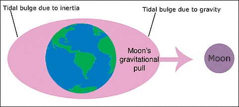
Predicting tides along coasts and at ports is much easier that predicting them in the open ocean. Robert Stewart wrote in the “Introduction to Physical Oceanography”: Data from a tide gauge plus the theory of tidal forcing gives an accurate description of tides near the tide gauge. Tidal Potential Tides are calculated from the hydrodynamic equations for a self-gravitating ocean on a rotating, elastic earth. The driving force is the gradient of the gravity field of the moon and sun. If the earth were an ocean planet with no land, and if we ignore the influence of inertia and currents, the gravity gradient produces a pair of bulges of water on earth, one on the side facing the moon or sun, one on the side away from the moon or sun. [Source: Robert Stewart, “Introduction to Physical Oceanography”, Texas A&M University, 2008]
To calculate the amplitude and phase of the tide on an ocean planet, we begin by calculating the tide-generating potential. This is much easier than calculating the forces. Ignoring for now earth’s rotation, the rotation of moon about earth produces a potential VM at any point on earth’s surface VM = −γM r1 where γ is the gravitational constant, and M is moon’s mass. The tidal forces are calculated from the spatial gradient of the potential.
The tide-generating force can be decomposed into components perpendicular P and parallel H to the sea surface. Tides are produced by the horizontal component. “The vertical component is balanced by pressure on the sea bed, but the ratio of the horizontal force per unit mass to vertical gravity has to be balanced by an opposing slope of the sea surface, as well as by possible changes in current momentum”. The tidal potential is symmetric about the earth-moon line, and it produces symmetric bulges.

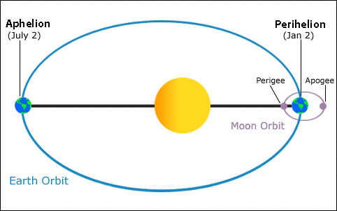
If we allow our ocean-covered earth to rotate, an observer in space sees the two bulges fixed relative to the earth-moon line as earth rotates. To an observer on earth, the two tidal bulges seems to rotate around earth because moon appears to move around the sky at nearly one cycle per day. Moon produces high tides every 12 hours and 25.23 minutes on the equator if the moon is above the equator. Notice that high tides are not exactly twice per day because the moon is also rotating around earth. Of course, the moon is above the equator only twice per lunar month, and this complicates our simple picture of the tides on an ideal ocean-covered earth. Furthermore, moon’s distance from earth R varies because moon’s orbit is elliptical and because the elliptical orbit is not fixed.
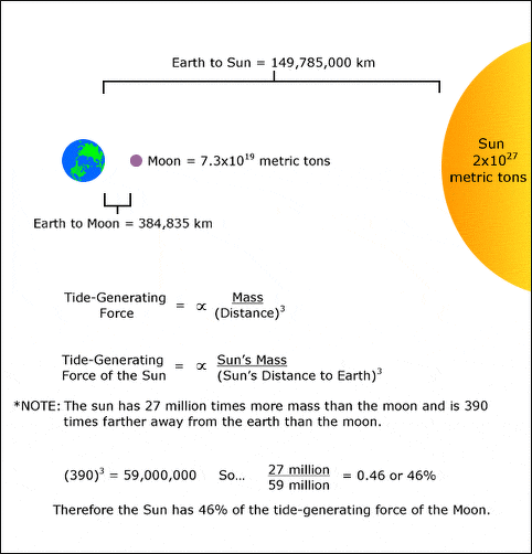
Clearly, the calculation of tides is getting more complicated than we might have thought. Before continuing on, we note that the solar tidal forces are derived in a similar way. The relative importance of the sun and moon are nearly the same. Although the sun is much more massive than moon, it is much further away. Before we can proceed further we need to know the position of moon and sun relative to earth. An accurate description of the positions in three dimensions is very difficult, and it involves learning arcane terms and concepts from celestial mechanics.
For more on this See “Introduction to Physical Oceanography” by Robert Stewart , Texas A&M University, 2008 uv.es/hegigui/Kasper
Predicting Tides for Ports and Shallow Water
According to the “Introduction to Physical Oceanography”: If tides in the ocean were in equilibrium with the tidal potential, tidal prediction would be much easier. Unfortunately, tides are far from equilibrium. The shallow-water wave which is the tide cannot move fast enough to keep up with sun and moon. On the equator, the tide would need to propagate around the world in one day. This requires a wave speed of around 460 meters per second, which is only possible in an ocean 22 kilometers deep. In addition, the continents interrupt the propagation of the wave. How to proceed? We can separate the problem of tidal prediction into two parts. The first deals with the prediction of tides in ports and shallow water where tides can be measured by tide gauges. The second deals with the prediction of tides in the deep ocean where tides are measured by satellite altimeters. [Source: Robert Stewart, “Introduction to Physical Oceanography”, Texas A&M University, 2008]
Two methods are used to predict future tides at a tide-gauge station using past observations of sea level measured at the gauge: 1) The Harmonic Method and 2) The Response Method
The Harmonic Method This is the traditional method, and it is still widely used. The method typically uses 19 years of data from a coastal tide gauge from which the amplitude and phase of each tidal constituent (the tidal harmonics) in the tide-gage record are calculated. The frequencies used in the analysis are specified in advance from the basic frequencies given in a table.

New system for measuring tides
Despite its simplicity, the technique had disadvantages compared with the response method described below. 1) More than 18.6 years of data are needed to resolve the modulation of the lunar tides. 2) Amplitude accuracy of 10−3 of the largest term require that at least 39 frequencies be determined. Doodson found 400 frequencies were needed for an amplitude accuracy of 10−4 of the largest term. 3) Non-tidal variability introduces large errors into the calculated amplitudes and phases of the weaker tidal constituents. The weaker tides have amplitudes smaller than variability at the same frequency due to other processes such as wind set up and currents near the tide gauge. 4) At many ports, the tide is non-linear, and many more tidal constituents are important. For some ports, the number of frequencies is unmanageable.
When tides propagate into very shallow water, especially river estuaries, they steepen and become non-linear. This generates harmonics of the original frequencies. In extreme cases, the incoming waves steepens so much the leading edge is nearly vertical, and the wave propagates as solitary wave. This is a tidal bore.
The Response Method This method, developed by Munk and Cartwright (1966), calculates the relationship between the observed tide at some point and the tidal potential. The relationship is the spectral admittance between the major tidal constituents and the tidal potential at each station. The admittance is assumed to be a slowly varying function of frequency so that the admittance of the major constituents can be used for determining the response at nearby frequencies. Future tides are calculated by multiplying the tidal potential by the admittance function. 1) The technique requires only a few months of data. 2) The tidal potential is easily calculated, and a knowledge of the tidal frequencies is not needed. 3) The admittance is Z(f) = G(f)/H(f). G(f) and H(f) are the Fourier transforms of the potential and the tide gage data, and f is frequency. 4) The admittance is inverse transformed to obtain the admittance as a function of time. 5) The technique works only if the waves propagate as linear waves.
Prediction of Tides in Deep-Water
Robert Stewart wrote in the “Introduction to Physical Oceanography”: Prediction of deep-ocean tides has been much more difficult than prediction of shallow-water tides because tide gauges were seldom deployed in deep water. All this changed with the launch of Topex/ Poseidon. The satellite was placed into an orbit especially designed for observing ocean tides (Parke et al. 1987), and the altimetric system was sufficiently accurate to measure many tidal constituents. Data from the satellite have now been used to determine deep-ocean tides with an accuracy of ± 2 cm. For most practical purposes, the tides are now known accurately for most of the ocean. Two avenues led to the new knowledge of deep-water tides using altimetry. [Source: Robert Stewart, “Introduction to Physical Oceanography”, Texas A&M University, 2008]
Prediction Using Hydrodynamic Theory: Purely theoretical calculations of tides are not very accurate, especially because the dissipation of tidal energy is not well known. Nevertheless, theoretical calculations provided insight into processes influencing ocean tides. Several processes must be considered: 1) The tides in one ocean basin perturb earth’s gravitational field, and the mass in the tidal bulge attracts water in other ocean basins. The selfgravitational attraction of the tides must be included. 2) The weight of the water in the tidal bulge is sufficiently great that it deforms the sea floor. The earth deforms as an elastic solid, and the deformation extends thousands of kilometers. 3) The ocean basins have a natural resonance close to the tidal frequencies. The tidal bulge is a shallow-water wave on a rotating ocean, and it propagates as a high tide rotating around the edge of the basin. Thus the tides are a nearly resonant sloshing of water in the ocean basin. The actual tide heights in deep water can be higher than the equilibrium values.

Old System for measuring tides
4) Tides are dissipated by bottom friction especially in shallow seas, by the flow over seamounts and mid-ocean ridges, and by the generation of internal waves over seamounts and at the edges of continental shelves. If the tidal forcing stopped, the tides would continue sloshing in the ocean basins for several days. 5) Because the tide is a shallow-water wave everywhere, its velocity depends on depth. Tides propagate more slowly over mid-ocean ridges and shallow seas. Hence, the distance between grid points in numerical models must be proportional to depth with very close spacing on continental shelves (LeProvost et al. 1994). 6) Internal waves generated by the tides produce a small signal at the sea surface near the tidal frequencies, but not phase-locked to the potential.
Altimetry Plus Response Method: Several years of altimeter data from Topex/ Poseidon (a joint satellite altimeter mission between NASA and CNES, the French space agency, that mapped ocean surface topography and was launched in 1992) .have been used with the response method to calculate deep-sea tides almost everywhere equatorward of 66 degrees. The altimeter measured sea-surface heights in geocentric coordinates at each point along the subsatellite track every 9.97 days. The temporal sampling aliased the tides into long frequencies, but the aliased periods are precisely known and the tides can be recovered (Parke et al. 1987). Because the tidal record is shorter than 8 years, the altimeter data are used with the response method to obtain predictions for a much longer time.
Solutions by ten different groups, have accuracy of ± 2.8 centimeters in deep water Altimeter data can be used directly with numerical models of the tides to calculate tides in all areas of the ocean from deep water all the way to the coast. Thus the technique is especially useful for determining tides near coasts and over sea-floor features where the altimeter ground track is too widely spaced to sample the tides well in space.
For more on this See “Introduction to Physical Oceanography” by Robert Stewart , Texas A&M University, 2008 uv.es/hegigui/Kasper
Image Sources: Wikimedia Commons; YouTube, NOAA
Text Sources: National Oceanic and Atmospheric Administration (NOAA) noaa.gov; “Introduction to Physical Oceanography” by Robert Stewart , Texas A&M University, 2008 uv.es/hegigui/Kasper ; Wikipedia, National Geographic, Live Science, BBC, Smithsonian, New York Times, Washington Post, Los Angeles Times, The New Yorker, Reuters, Associated Press, Lonely Planet Guides and various books and other publications.
Last Updated March 2023