Home | Category: Physical Oceanography
LOOP CURRENT
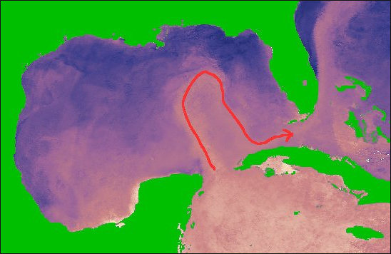
Loop Current in the Gulf of Mexico
The Loop Current is an area of warm water that travels up from the Caribbean, past the Yucatan Peninsula, and into the Gulf of Mexico. The current is also known as the Florida current as it flows through the Florida Strait, into the Gulf Stream, and heads north up the eastern coast of the U.S. [Source: NOAA]
From the south, the Gulf of Mexico is fed by a current of warm water from the Caribbean, which enters the Gulf between Mexico's Yucatan Peninsula and Cuba. This forms the Gulf Loop Current, which curves east and south along Florida's coast and exits through the Straits of Florida.
The Gulf Loop is variable. Sometimes, the current barely enters the Gulf of Mexico before heading towards the Atlantic. At other times, it may travel nearly to the coast of Louisiana before swinging back towards the Florida Strait. Typically the loop current in winter in the center of the Gulf of Mexico is large and warm, while chilled water draining the Mississippi River watershed envelop the bayous and bays of Louisiana.
Related Articles:
OCEAN CURRENTS: FORCES, CONCEPTS, TYPES, MAPS ioa.factsanddetails.com
TYPES OF OCEAN CURRENTS: GYRES, EDDIES, UPWELLING ioa.factsanddetails.com
OCEAN TIDES: TYPES, TERMS, FORCES, MEASUREMENTS AND PREDICTIONS ioa.factsanddetails.com
OCEANS, WINDS AND WEATHER ioa.factsanddetails.com
OCEANOGRAPHY AND STUDYING THE SEA ioa.factsanddetails.com ;
WAVES IN THE OCEAN: TYPES, CAUSES, AND EFFORTS TO DESCRIBE, PREDICT AND MEASURE THEM ioa.factsanddetails.com ;
PHYSICAL FEATURES OF THE OCEAN FLOOR: TRENCHES, VENTS, MOUNTAINS ioa.factsanddetails.com
LARGE WAVES: ROUGE WAVES, METEOTSUNAMIS AND THE BIGGEST WAVES EVER ioa.factsanddetails.com
Websites and Resources: National Oceanic and Atmospheric Administration (NOAA) noaa.gov; “Introduction to Physical Oceanography” by Robert Stewart , Texas A&M University, 2008 uv.es/hegigui/Kasper ; Woods Hole Oceanographic Institute whoi.edu ; Cousteau Society cousteau.org ; Monterey Bay Aquarium montereybayaquarium.org
RECOMMENDED BOOKS:
“Ocean Currents: Physical Drivers in a Changing World” by Robert Marsh, Erik van Sebille Amazon.com
“Ocean Currents and Their Effects on the Global Climate System” by Alexander Moreau (2025) Amazon.com
The “Great Ocean Conveyor: Discovering the Trigger for Abrupt Climate Change”
by Wally Broecker Amazon.com
“Gulf Stream Chronicles: A Naturalist Explores Life in an Ocean River” by David S. Lee and Leo Schleicher (Illustrator) Amazon.com
“The Gulf Stream: Encounters With the Blue God” by William MacLeish(1989) Amazon.com
“Ocean Circulation” Open University(2001) Amazon.com
“Adrift: The Curious Tale of the Lego Lost at Sea” by Tracey Williams (2022) Amazon.com
“Waves, Tides and Shallow-Water Processes” Open University(1989) Amazon.com
“Tides: The Science and Spirit of the Ocean” by Jonathan White Amazon.com
“The Wave: In Pursuit of the Rogues, Freaks, and Giants of the Ocean” by Susan Casey (2010) Amazon.com
“Waves in Oceanic and Coastal Waters” by Leo H. Holthuijsen (2007) Amazon.com
“Descriptive Physical Oceanography” by Lynne Talley (2017) Amazon.com
“Essentials of Oceanography” by Alam Trujillo and Harold Thurman Amazon.com
“The Blue Machine: How the Ocean Works” by Helen Czerski, explains how the ocean influences our world and how it functions. Amazon.com
“How the Ocean Works: An Introduction to Oceanography” by Mark Denny (2008) Amazon.com
“The Science of the Ocean: The Secrets of the Seas Revealed” by DK (2020) Amazon.com
“Atmospheric and Oceanic Fluid Dynamics: Fundamentals and Large-Scale Circulation” by Geoffrey K. Vallis (2006) Amazon.com
“The Unnatural History of the Sea” by Callum Roberts (Island Press (2009) Amazon.com
“Ocean: The World's Last Wilderness Revealed” by Robert Dinwiddie , Philip Eales, et al. (2008) Amazon.com
“Blue Hope: Exploring and Caring for Earth's Magnificent Ocean” by Sylvia Earle (2014) Amazon.com
“National Geographic Ocean: A Global Odyssey” by Sylvia Earle (2021) Amazon.com
Gulf Stream
The Gulf Stream an intense, warm ocean current in the western North Atlantic Ocean that carries warm water from the Gulf of Mexico and the Caribbean northward along the east coast of the United States. It moves north along the coast of Florida and then turns eastward off of North Carolina, flowing northeast across the Atlantic and branches into northeast-heading North Atlantic Current and southeast-heading Azores current, both of which bring warmth to Europe.
The main conveyor of heat from south to north in the Atlantic, the Gulf Stream begins in the Caribbean Sea, a relatively shallow basin. Forces from the spinning of the earth and the trade winds push Caribbean waters north and west between Cuba and the Yucatan into the Gulf of Mexico. From there is like a vast warm river, 80 kilometers wide and 500 meters deep.
The Gulf Stream process begins with the Trade Winds (blowing from east to west), which blows Atlantic waters westward to the Gulf of Mexico. Here the water is stopped by Gulf water. Because of the configuration of the geography of the Yucatan peninsula, the water is forced northward between Cuba and Florida and joins waters of the Antilles current. Around Cape Hatteras, North Carolina, where the water is around 88 degrees F in the summer and 69 degrees F in the winter, the current begins heading eastward towards Europe.
See Separate Article: GULF STREAM, THE AMOC AND CLIMATE CHANGE ioa.factsanddetails.com
California Current
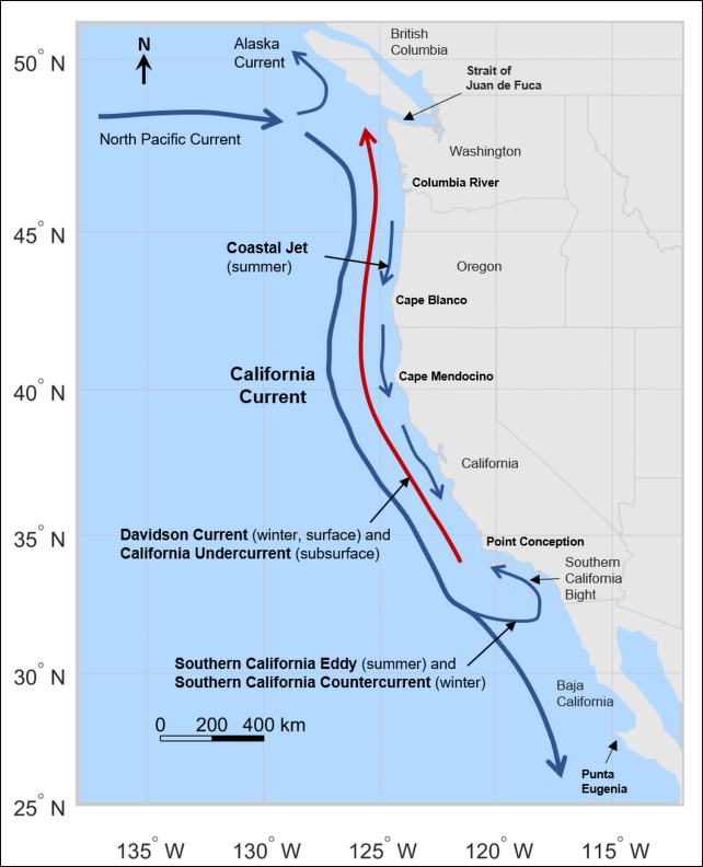
California Current
The California Current is a cold water Pacific Ocean current that moves southward along the western coast of North America, beginning off southern British Columbia and ending off southern Baja California Sur. It is considered an Eastern boundary current due to the influence of the North American coastline on its course and is part of the North Pacific Gyre, a large swirling current that occupies the northern basin of the Pacific. [Source: Wikipedia]
The movement of Alaskan and northern ocean currents southward down the west coast results in much cooler ocean and land temperatures in the region, especially when compared to similar latitudes on the east coast of the United States, which is influenced by the Gulf Stream. For example, Half Moon Bay at 37°N has no month with an average high above 67 °F (19 °C) and San Francisco often stays below 70 °F (21 °C) in summer, while Virginia Beach, close to the same latitude, has high temperatures above 80 °F (27 °C) in summer.
Upwelling process off the coast of California brings in cooler, nutrient rich water up to the surface. The upwelling of colder sub-surface waters is caused by the prevailing northwesterly winds acting through the Ekman Effect. The winds drive surface water to the right of the wind flow, that is offshore, which draws water up from below to replace it. The upwelling further cools the already cool California Current. This is the mechanism that produces California's characteristic coastal fog and cool ocean waters. The upwelling supports large populations of whales, seabirds and sea creatures.
Humboldt Current
The Humboldt Current (also known as the Peru Current) is a cold water current that carryies water from the Antarctic northward along the Chilean and Peruvian coasts. The temperature of the water is up to 15̊ F cooler than water found elsewhere at similar latitudes. The current is named after the German explorer Alexander von Humboldt, who theorized that the Current was partly the result of surface winds that blew water away from the coast.
The current is so strong that efforts to investigate the crash of a Boeing 757 in 300 meters (660 feet) of water were hampered when the currents moved the plane to a new location 24 hours after it crashed and investigators couldn't find it.
Humboldt Current nourishes one of the world's largest fisheries. Offshore winds in Peru cause the coastal to blow out to sea and be displaced by nutrient rich cold water from the depths of the ocean. The 8,060-meter (26,443-foot) -deep Peru–Chile Trench, the world 10th deepest trench, lies near the current. The nutrients supports trillions of microscopic plant and animals which in turn feed fish and birds.
Currents in Southern Africa

Currents Around South Africa
The climate and ocean conditions in souther Africa are influenced by the warm Mozambique (Agulhas) Current and the cold Benguela Current. The warm Agulhas ocean current sweeps southward along the Indian Ocean coastline in the east for several months of the year. The cold Benguela current sweeps northward along the Atlantic Ocean coastline in the west.
The climate and vegetation of Namibia and southern Africa are shaped by the Benguela current which carries water from to Antarctic along South Africa's west coast and Namibia, creating a climate that starts out green in the south and gets progressively dryer as one head north.
The same winds that blow the fogs inland in Namibia also blow water off the ocean's surface, allowing upwelling currents to bring up nutrients from the bottom of the sea. These nutients supply food for plankton which in turn supports large numbers of sea birds, fish and sea mammal. Dolphins, seals, cormorants, white pelicans and gannet feed on the massive schools of anchovy and pilchard. Large colonies of seals and seabird gather on the rocky islands offshore. Those that breed on the land sometimes fall prey to jackals and hyenas. The lions that used to roam the area were largely killed off by poachers and farmers). Predators unfortunately have also taken their toll of the rare Damara tern, of which only 4000 or so birds remain.
The Skeleton Coast, which stretches along the northern parts of the Namibian coastline, is one of the earth's most inhospitable places. It has treacherous shorelines with coastal fogs and cold sea breezes caused by the Benguela current. These shorelines became the graveyard of numerous ships and mariners. The impenetrability of the area may have been one of the reasons the people of this part of the world were spared the excesses of the Atlantic slave trade that raged along the West African coast.
Japanese Ocean Currents
The Kuroshio Current (also known as the Japan Current) off the east coast of Japan is the Pacific’s answer to the Gulf Stream. It brings warm water up from the Philippines in the south and like the Gulf Stream in the Atlantic is part of clockwise gyre that in the case of the Kuroshio Current embraces almost all of the perimeter of the northern Pacific. Waters from the Kuroshio and a branch current called the Tsushima Current mix with waters from the Oyashio Current, a cold water current that flows southward along the Kuril Islands and the Pacific coasts of Hokkaido and northern Honshu. Kuroshio means “Black Tide.”
The Kuroshio Current has produced the northernmost colony of table coral off the southern coast of Wakayama Prefecture. Kushimoto Marine Park in this area contains 120 species of coral and a great variety of fish normally associated with more southern seas. The current has only been flowing to this area since 1990.
The Oyashio current brings cold water from the north. It affects the Pacific Ocean side of Hokkaido. The sea of Okhotsk north of Hokkaido is also very cold and becomes completely covered by pack ice in the winter. Among the cold-water species of fish that thrive in these waters are halibut, cod, salmon and Atka mackeral. Describing the watery world between ice floes in the Sea of Okhotsk, bordering the Shiretoko Peninsula in northern Hokkaido.
The migration of marine life is often tied with the currents. Squid and fish such as bonito, horse mackerel move northward with Kuroshio while cold water species such as cod, halibut and Alaska pollack move south with the Oyashio. In 2009 and 2010 a number oarfish — strange ribbon-like creatures that normally live at depths between 200 meters and meters and aren’t seem near the surface — were seen in coastal waters in the Sea of Japan. They were most often spotted when strong winds blew from the sea.

Deep Sea Ocean Circulation
Deep Sea Ocean Circulation
Robert Stewart wrote in the “Introduction to Physical Oceanography”: The direct forcing of the oceanic circulation by wind is strongest in the upper kilometer of the water column. Below a kilometer lies the vast water masses of the ocean extending to depths of 4–5 kilometers. The water is everywhere cold, with a potential temperature less than 4 degrees C. The water mass is formed when cold, dense water sinks from the surface to great depths at high latitudes. It spreads out from these regions to fill the ocean basins. Deep mixing eventually pulls the water up through the thermocline over large areas of the ocean. It is this upward mixing that drives the deep circulation. The vast deep ocean is usually referred to as the abyss, and the circulation as the abyssal circulation. [Source: Robert Stewart, “Introduction to Physical Oceanography”, Texas A&M University, 2008]
The densest water at the sea surface, water that is dense enough to sink to the bottom, is formed when frigid air blows across the ocean at high latitudes in winter in the Atlantic between Norway and Greenland and near Antarctica. The wind cools and evaporates water. If the wind is cold enough, sea ice forms, further increasing the salinity of the water because ice is fresher than sea water. Bottom water is produced only in these two regions. Cold, dense water is formed in the North Pacific, but it is not salty enough to sink to the bottom.
At mid and low latitudes, the density, even in winter, is sufficiently low that the water cannot sink more than a few hundred meters into the ocean. The only exception are some seas, such as the Mediterranean Sea, where evaporation is so great that the salinity of the water is sufficiently great for the water to sink to the bottom of these seas. If these seas can exchange water with the open ocean, the waters formed in winter in the seas mixes with the water in the open ocean and it spreads out along intermediate depths in the open ocean.
Many terms have been used to describe the deep circulation. They include: 1) abyssal circulation, 2) thermohaline circulation 3) meridional overturning circulation, and 4) global conveyor. The term thermohaline circulation was once widely used, but it has almost entirely disappeared from the oceanographic literature. It is no longer used because it is now clear that the flow is not density driven, and because the concept has not been clearly defined. The meridional overturning circulation is better defined. It is the zonal average of the flow plotted as a function of depth and latitude. Plots of the circulation show where vertical flow is important, but they show no information about how circulation in the gyres influences the flow.
Deep circulation is defined as a circulation of mass. Of course, the mass circulation also carries heat, salt, oxygen, and other properties. But the circulation of the other properties is not the same as the mass transport. For example, the north Atlantic imports heat but exports oxygen. The production of bottom water is influenced by the surface salinity and winds in the north Atlantic. Saltier surface waters form denser water in winter than less salty water. At first you may think that temperature is also important, but at high latitudes water in all ocean basins gets cold enough to freeze, so all ocean produce −2 degrees C water at the surface. Of this, only the most salty will sink, and the saltiest water is in the Atlantic and under the ice on the continental shelves around Antarctica. The production of bottom water is remarkably sensitive to small changes in salinity. The production of bottom water is also remarkably sensitive to small changes in mixing in the deep ocean.

Gulf Stream Cold and Warm Water circulation
Theory for the Deep Circulation
According to the “Introduction to Physical Oceanography”: Stommel, Arons, and Faller in a series of papers from 1958 to 1960 described a simple theory of the abyssal circulation. The theory differed so greatly from what was expected that Stommel and Arons devised laboratory experiments with rotating fluids to confirmed their theory. Stommel, Arons, Faller theory is based on three fundamental ideas: 1) Cold, deep water is supplied by deep convection at a few high-latitude locations in the Atlantic, notably in the Irminger and Greenland Seas in the north and the Weddell Sea in the south. 2) Uniform mixing in the ocean brings the cold, deep water back to the surface. 3) The deep circulation is strictly geostrophic in the interior of the ocean, and therefore potential vorticity is conserved. [Source: Robert Stewart, “Introduction to Physical Oceanography”, Texas A&M University, 2008]
Notice that the deep circulation is driven by mixing, not by the sinking of cold water at high latitudes. Munk and Wunsch (1998) point out that deep convection by itself leads to a deep, stagnant, pool of cold water. In this case, the deep circulation is confined to the upper layers of the ocean. Mixing or upwelling is required to pump cold water upward through the thermocline and drive the deep circulation. Winds and tides are the primary source of energy driving the mixing. Notice also that convection and sinking are not the same, and they do not occur in the same place . Convection occurs in small regions a few kilometers on a side. Sinking, driven by Ekman pumping and geostrophic currents, can occur over far larger areas. In this chapter, we are discussing mostly sinking of water.
Other important processes worth noting include: 1) The deep circulation is driven by vertical mixing, which is largest above mid-ocean ridges, near seamounts, and in strong boundary currents. 2) The deep circulation is too weak to measure directly. It is inferred from observations of water masses defined by their temperature and salinity and from observation of tracers.
Importance of the Deep Circulation
According to the “Introduction to Physical Oceanography”: Deep circulation carries heat, salinity, oxygen, CO2, and other properties from high latitudes in winter to lower latitudes throughout the world. This has very important consequences. 1) The contrast between the cold deep water and the warm surface waters determines the stratification of the ocean, which strongly influences ocean dynamics. 2) The volume of deep water is far larger than the volume of surface water. Although currents in the deep ocean are relatively weak, they have transports comparable to the surface transports. 3) The fluxes of heat and other variables carried by the deep circulation influences earth’s heat budget and climate. The fluxes vary from decades to centuries to millennia, and this variability modulates climate over such time intervals. The ocean may be the primary cause of variability over times ranging from years to decades, and it may have helped modulate ice-age climate. [Source: Robert Stewart, “Introduction to Physical Oceanography”, Texas A&M University, 2008]
Two aspects of the deep circulation are especially important for understanding earth’s climate and its possible response to increased carbon dioxide CO2 in the atmosphere: A) the ability of cold water to store CO2 and heat absorbed from the atmosphere, and B) the ability of deep currents to modulate the heat transported from the tropics to high latitudes. The ocean is the primary reservoir of readily available CO2, an important greenhouse gas. The ocean contain 40,000 GtC of dissolved, particulate, and living forms of carbon. The land contains 2,200 GtC, and the atmosphere contains only 750 GtC. Thus the ocean hold 50 times more carbon than the air.
How much and how long CO2 is stored in the ocean depends on the transport of CO2 by the deep circulation and on the net flux of carbon deposited on the sea floor. The amount that dissolves depends on the temperature of the deep water, the storage time in the deep ocean depends on the rate at which deep water is replenished, and the deposition depends on whether the dead plants and animals that drop to the sea floor are oxidized. Increased ventilation of deep layers, and warming of the deep layers could release large quantities of the gas to the atmosphere. The storage of carbon in the ocean also depends on the dynamics of marine ecosystems, upwelling, and the amount of dead plants and animals stored in sediments.
Antarctic Circumpolar Current
The Antarctic Circumpolar Current mixes deep water from the Atlantic, Pacific, and Indian Ocean and redistributes it back to each ocean. The current is deep and slow with a transport of 125 Sv. A Sv is equal to 1 million cubic meters per second. According to the “Introduction to Physical Oceanography”: “The Antarctic Circumpolar Current is an important feature of the ocean’s deep circulation because it transports deep and intermediate water between the Atlantic, Indian, and Pacific Ocean, and because Ekman pumping driven by westerly winds is a major driver of the deep circulation. The current is also very important for understanding the deep circulation in all oceans. [Source: Robert Stewart, “Introduction to Physical Oceanography”, Texas A&M University, 2008]
A plot of density across a line of constant longitude in the Drake Passage shows three fronts. They are, from north to south: 1) the Subantarctic Front, 2) the Polar Front, and 3) the Southern acc Front. Each front is continuous around Antarctica. The plot also shows that the constant-density surfaces slope at all depths, which indicates that the currents extend to the bottom.
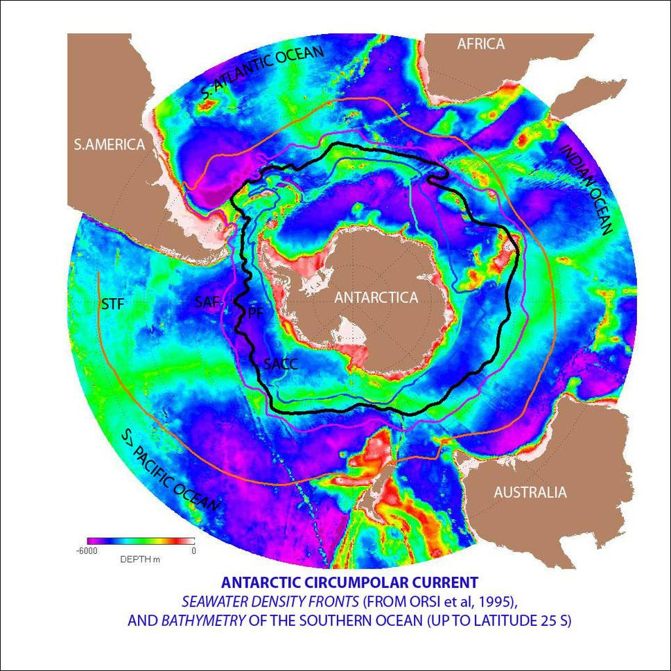
Antarctic Circumpolar Current
Typical current speeds are around 10 centimeters per second with speeds of up to 50 centimeters per second near some fronts. Although the currents are slow, they transport much more water than western boundary currents because the flow is deep and wide. Whitworth and Peterson (1985) calculated transport through the Drake Passage using several years of data from an array of 91 current meters on 24 moorings spaced approximately 50 kilometers apart along a line spanning the passage. They also used measurements of bottom pressure measured by gauges on either side of the passage. They found that the average transport through the Drake Passage was 125±11 Sv, and that the transport varied from 95 Sv to 158 Sv. The maximum transport tended to occur in late winter and early spring. Because the antarctic currents reach the bottom, they are influenced by topographic steering. As the current crosses ridges such as the Kerguelen Plateau, the Pacific-Antarctic Ridge, and the Drake Passage, it is deflected by the ridges.
The core of the current is composed of Circumpolar Deep Water, a mixture of deep water from all ocean. The upper branch of the current contains oxygen-poor water from all ocean. The lower (deeper) branch contains a core of high-salinity water from the Atlantic, including contributions from the north Atlantic deep water mixed with salty Mediterranean Sea water. As the different water masses circulate around Antarctica they mix with other water masses with similar density. In a sense, the current is a giant ‘mix-master’ taking deep water from each ocean, mixing it with deep water from other ocean, and then redistributing it back to each ocean.
Equatorial Ocean Currents
According to the “Introduction to Physical Oceanography”: Equatorial processes are at the center of our understanding the influence of the ocean on the atmosphere, and they dominate the interannual fluctuations in global weather patterns. The sun warms the vast expanses of the tropical Pacific and Indian ocean, evaporating water. When the water condenses as rain it releases so much heat that these areas are the primary engine driving the atmospheric circulation . Rainfall over extensive areas exceeds three meters per, and some oceanic regions receive more than five meters of rain per year. To put the numbers in perspective, five meters of rain per year releases on average 400 watts per square meter of heat to the atmosphere. Equatorial currents modulate the air-sea interactions, especially through the phenomenon known as El Niño, with global consequences. [Source: Robert Stewart, “Introduction to Physical Oceanography”, Texas A&M University, 2008]
The tropical ocean is characterized by a thin, permanent, shallow layer of warm water over deeper, colder water. In this respect, the vertical stratification is similar to the summer stratification at higher latitudes. Surface waters are hottest in the west in the great Pacific warm pool. The mixed layer is deep in the west and very shallow in the east. The shallow thermocline has important consequences. The southeast trade winds blow along the equator although they tend to be strongest in the east. North of the equator, Ekman transport is northward. South of the equator it is southward. The divergence of the Ekman flow (a component of wind-driven ocean influenced by wind friction and the Coriolis effect) causes upwelling on the equator. In the west, the upwelled water is warm. But in the east the upwelled water is cold because the thermocline is so shallow. This leads to a cold tongue of water at the sea surface extending from South America to near the dateline.
Surface temperature in the east is a balance among four processes: 1) The strength of the upwelling, which is determined by the westward component of the wind. 2) The speed of westward currents which carry cold water from the coast of Peru and Ecuador. 3) North-south mixing with warmer waters on either side of the equator. 4) Heat fluxes through the sea surface along the equator.
The east-west temperature gradient on the equator drives a zonal circulation in the atmosphere, the Walker circulation. Thunderstorms over the warm pool carry air upward, and sinking air in the east feeds the return flow at the surface. Variations in the temperature gradient influences the Walker circulation, which, in turn, influences the gradient. The feedback can lead to an instability, the El Niño-Southern Oscillation.
The strong stratification confines the wind-driven circulation to the mixed layer and upper thermocline.

North Equatorial Current in the Atlantic
Equatorial Surface Currents
Robert Stewart wrote in the “Introduction to Physical Oceanography”: Surface currents in the tropical Atlantic, Pacific, and Indian ocean include The North Equatorial Countercurrent between 3 degrees N and 10 degrees N, which flows eastward with a typical surface speed of 50 centimeters per second. The current is centered on the band of weak winds, the doldrums, around 5–10 degrees N where the north and south trade winds converge, the tropical convergence zone. [Source: Robert Stewart, “Introduction to Physical Oceanography”, Texas A&M University, 2008]
The North and South Equatorial Currents which flow westward in the zonal band on either side of the countercurrent. The currents are shallow, less than 200 meters deep. The northern current is weak, with a speed less than roughly 20 centimeters per second. The southern current has a maximum speed of around 100 centimeters per second, in the band between 3 degrees N and the equator.
The currents in the Atlantic are similar to those in the Pacific because the trade winds in that ocean also converge near 5 degrees –10 degrees N. The South Equatorial Current in the Atlantic continues northwest along the coast of Brazil, where it is known as the North Brazil Current. In the Indian Ocean, the doldrums occur in the southern hemisphere and only during the northern-hemisphere winter. In the northern hemisphere, the currents reverse with the monsoon winds. There is, however, much more to the story of equatorial currents.
Equatorial Undercurrents
Just a few meters below the surface on the equator is a strong eastward flowing current, the Equatorial Undercurrent, the last major oceanic current to be discovered. The current is remarkable in that, even though comparable in transport to the Florida Current, its presence was unsuspected.
In September 1951, aboard the U.S. Fish and Wildlife Service research vessel long-line fishing on the equator south of Hawaii, it was noticed that the subsurface gear drifted steadily to the east. The next year Townsend Cromwell, in company with Montgomery and Stroup, led an expedition to investigate the vertical distribution of horizontal velocity at the equator. Using floating drogues at the surface and at various depths, they were able to establish the presence, near the equator in the central Pacific, of a strong, narrow eastward current in the lower part of the surface layer and the upper part of the thermocline. A few years later the Scripps Eastropac Expedition, under Cromwell’s leadership, found the current extended toward the east nearly to the Galapagos Islands but was not present between those islands and the South American continent. Warren S. Wooster said in 1960: Neither the source nor the ultimate fate of its waters has been established. No theory of oceanic circulation predicted its existence, and only now are such theories being modified to account for the important features of its flow. [Source: Robert Stewart, “Introduction to Physical Oceanography”, Texas A&M University, 2008]
The Equatorial Undercurrent in the Atlantic was first discovered by Buchanan in 1886, and in the Pacific by the Japanese Navy in the 1920s and 1930s. However, no attention was paid to these observations. Other earlier hints regarding this undercurrent were mentioned by Matth¨aus (1969). Thus the old experience becomes even more obvious which says that discoveries not attracting the attention of contemporaries simply do not exist. — Dietrich et al. (1980).

North Equatorial Current in the Pacific
Bob Arthur (1960) summarized the major aspects of the flow: 1) Surface flow may be directed westward at speeds of 25–75 centimeters per second; 2) Current reverses at a depth of from 20 to 40 meters; 3) Eastward undercurrent extends to a depth of 400 meters with a transport of as much as 30 Sv = 30 × 106 cubic meters per second; 4. Core of maximum eastward velocity (0.50–1.50 meters per second) rises from a depth of 100 meters at 140 degrees W to 40 meters at 98 degrees W, then dips down; 5. Undercurrent appears to be symmetrical about the equator and becomes much thinner and weaker at 2 degrees N and 2 degrees S.
In essence, the Pacific Equatorial Undercurrent is a ribbon with dimensions of 0.2 kilometers × 300 kilometers × 13, 000 kilometers. Coriolis forces keep the equatorial undercurrent centered on the equator. If the flow strays northward, the Coriolis force deflects the current southward. The opposite occurs if the flow strays southward.
Image Sources: Wikimedia Commons; YouTube, NOAA
Text Sources: National Oceanic and Atmospheric Administration (NOAA) noaa.gov; “Introduction to Physical Oceanography” by Robert Stewart , Texas A&M University, 2008 uv.es/hegigui/Kasper ; Wikipedia, National Geographic, Live Science, BBC, Smithsonian, New York Times, Washington Post, Los Angeles Times, The New Yorker, Reuters, Associated Press, Lonely Planet Guides and various books and other publications.
Last Updated November 2025