Home | Category: Oceans and Sea Life
OCEANS

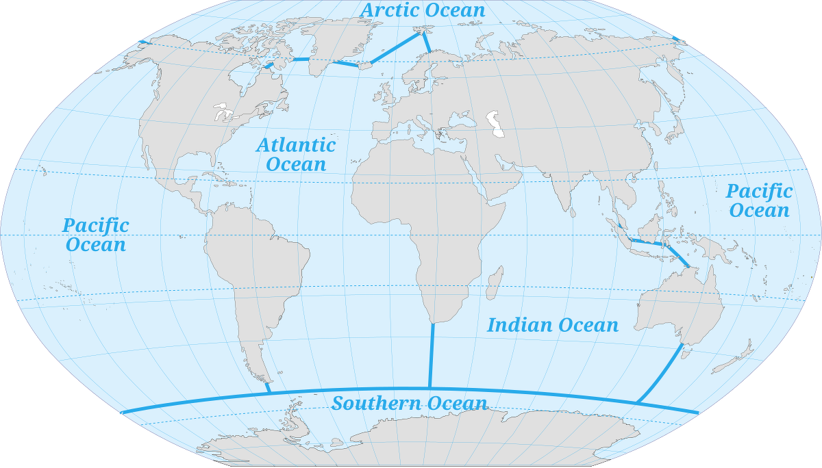
According to some reckonings there is only one ocean. By international agreement, it is divided into three named parts: the Atlantic, Pacific, and Indian Oceans (International Hydrographic Bureau, 1953). Seas, which are part of the ocean, are defined in several ways (See Below). [Source: Robert Stewart, Introduction to Physical Oceanography, Texas A&M University, 2008).
The global ocean covers 71 percent of Earth's surface and is divided into distinct regions with names. The boundaries between these regions have evolved over time for historical, cultural, geographical, and scientific reasons. Historically, there have been four named oceans: the Atlantic, Pacific, Indian, and Arctic. However, most countries, including the United States, now recognize the Southern (Antarctic) Ocean as the fifth. The Pacific, Atlantic, and Indian oceans are the most well-known.
The Pacific Ocean is the largest and deepest of the world's ocean basin The Atlantic basin is the second largest basin, followed by the Indian Ocean basin, the Southern Ocean, and finally the Arctic Ocean basin. The largest ocean that ever existed on our planet was Panthalassa, a world-spanning sea that surrounded the supercontinent Pangaea from about 300 million to 200 million years ago. The Pacific covers more than 30 percent of the planet's surface and stretches 19,000 kilometers (12,000 miles) at its widest point, between Colombia and the Malay Peninsula.
Robert Stewart wrote in the “Introduction to Physical Oceanography”: The Pacific Ocean extends northward from Antarctica to the Bering Strait. The boundary between the Pacific and Indian Ocean follows the line from the Malay Peninsula through Sumatra, Java, Timor, Australia at Cape Londonderry, and Tasmania. From Tasmania to Antarctica it is the meridian of South East Cape on Tasmania 147◦E. The Indian Ocean extends from Antarctica to the continent of Asia including the Red Sea and Persian Gulf. The boundary between the Atlantic and Pacific is the line forming the shortest distance from Cape Horn to the South Shetland Islands. In the north, the Arctic Sea is part of the Atlantic Ocean, and the Bering Strait is the boundary between the Atlantic and Pacific. [Source: Robert Stewart, “Introduction to Physical Oceanography”, Texas A&M University, 2008]
The Southern Ocean is the 'newest' named ocean. It is recognized by the U.S. Board on Geographic Names as the body of water extending from the coast of Antarctica to the line of latitude at 60 degrees South.
Related Articles:
SEAS AND OCEANS: DEFINITIONS, FEATURES ioa.factsanddetails.com
PHYSICAL FEATURES OF THE OCEAN FLOOR: TRENCHES, VENTS, MOUNTAINS ioa.factsanddetails.com
ISLANDS: TYPES, HOW THEY FORM, FEATURES AND NATIONS ioa.factsanddetails.com
LARGE WAVES: ROUGE WAVES, METEOTSUNAMIS AND THE BIGGEST WAVES EVER ioa.factsanddetails.com
OCEAN CURRENTS ioa.factsanddetails.com
SURVIVORS AT SEA: ADRIFT FOR MONTHS, ALONE IN A RAFT AND 480 METERS UNDERWATER ioa.factsanddetails.com
Websites and Resources: National Oceanic and Atmospheric Administration (NOAA) noaa.gov; “Introduction to Physical Oceanography” by Robert Stewart , Texas A&M University, 2008 uv.es/hegigui/Kasper ; Woods Hole Oceanographic Institute whoi.edu ; Cousteau Society cousteau.org ; Monterey Bay Aquarium montereybayaquarium.org
RECOMMENDED BOOKS:
“The Unnatural History of the Sea” by Callum Roberts (Island Press (2009). Roberts is a professor of marine conservation at the University of York in England Amazon.com
“Ocean: The World's Last Wilderness Revealed” by Robert Dinwiddie , Philip Eales, et al. (2008) Amazon.com
“Into the Great Wide Ocean: Life in the Least Known Habitat on Earth” by Sönke Johnsen (2024) Amazon.com
“An Introduction to the World's Oceans” by Keith A. Sverdrup (1984) Amazon.com
“The Sea Around Us” by Rachel Carson, an influential work that highlights the importance of ocean conservation (1950) Amazon.com
“The Life & Love of the Sea” by Lewis Blackwell Amazon.com
“Song for the Blue Ocean” by Carl Safina (1998) Amazon.com
“Blue Hope: Exploring and Caring for Earth's Magnificent Ocean” by Sylvia Earle (2014) Amazon.com
“National Geographic Ocean: A Global Odyssey” by Sylvia Earle (2021) Amazon.com
“Deep: Freediving, Renegade Science, and What the Ocean Tells Us About Ourselves” by James Nestor, investigates the ocean and human physiology through freediving. Amazon.com
“The Log from the Sea of Cortez” by John Steinbeck (Penguin Classics) (1951) Amazon.com
“The Ocean Book: The Stories, Science, and History of Oceans” by DK (2025) Amazon.com
“Ocean Art: From the Shore to the Deep” by Helen Scales (2025) Amazon.com
Pacific Ocean
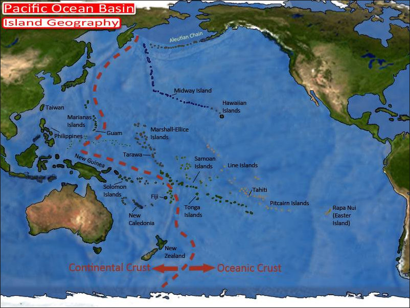
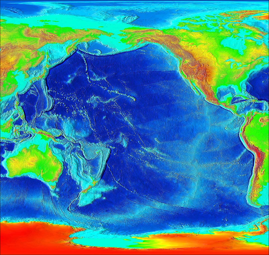
Covering approximately 181 million square kilometers (63 million square miles) and containing more than half of the free water on Earth, the Pacific is far and away the largest of the world’s oceans. All of the world’s continents could fit into the Pacific basin. The Pacific is also the oldest of the existing ocean basins. Its oldest rocks have been dated at about 200 million years. The Pacific basin is referred to as the “Ring of Fire” due to intense earthquake and volcanic activity occurring near areas of tectonic plate subduction (where one tectonic plate is forced under another). [Source: NOAA]
The Pacific Ocean stretches for 17,700 kilometers (11,000 miles) at the equator. It is 20 times as large as the U.S. and twice as large as the Atlantic. It encompasses half of the world's oceans and covers one third of the earth's surface. The Pacific Ocean is also deepest of the world's ocean. It contains the Marianas Trench, the deepest point in the world's ocean. Running for 2,950 kilometers (1835 miles) on the eastern side of the Marianas islands, just south of Guam, it is a deep sea canyon with a maximum depth of 11,034 meters (36,201 feet). This is more than seven miles. Mount Everest is less than six miles high. The distance between the lowest point in the Marianas Trench and the highest on the Marianas islands is the greatest elevation change on earth.
Terence E. Hays wrote in the “Encyclopedia of World Cultures”: “If you turn a globe just so, all you can see is the Pacific Ocean, the earth's largest geographic feature. It is greater than that of all of the world's land areas combined; however, even when Australia is included, the Pacific contains only about 9 million square kilometers of dry land. The rest consists of more than half of the world's volume of free water, with an average depth of over 4,000 meters. From the Bering Strait in the north to the Antarctic Circle is a distance of more than 14,700 kilometers, and to cross the Pacific at its greatest width, between Singapore and Panama, one must travel about 19,700 kilometers. [Source:“Encyclopedia of World Cultures, Volume 2: Oceania,” edited by Terence E. Hays, 1991 |~|]
“Perhaps not surprising in the face of such immensity (especially to the modem air traveler), the most characteristic feature of the Pacific Ocean is emptiness. Although it contains more islands than are found in all other oceans combined, the overwhelming majority of the tens of thousands of islands of Oceania are in the southwestern quadrant of the Pacific. But this is still a very large area.
Discovery and Naming of the Pacific Ocean
People living along the west coast of the Americas and the east coasts of Asia and Australia have known of the Pacific Ocean for millennia. Ancient Polynesians used double-hulled sailing canoes to cover vast distances in the Pacific long before Europeans appeared on the scene. By A.D. 1300, Polynesians had settled more than 10 million square miles of the Pacific Ocean roughly between New Zealand, Hawaii and Easter Island.
Vasco Núnez de Balboa (1474-1517) was the first European recorded to have laid eyes on the the Pacific Ocean, which he named the South Sea. He hacked through dense tropical rain forests for 25 days with 190 Spaniards and several hundred Indian guides and porters to reach the Pacific in 1513. When the reached a peak with a view of the Pacific on September 25, 1513, Balboa ascended first while his men had to wait behind. "Kneeling on the ground, he raised his hands to heaven and saluted the south sea,” according to his account he gave “thanks to God and all the saints for having reserved this glory for him, an ordinary man, devoid a like of experience and authority." He then invited his men to join him and exclaimed, "Behold the much desired ocean! Behold! all ye men, who have shared such efforts behold the country of which the sons of Comogre and other natives have told us such wonders!" After four day more days walking and being carried by Indians, Balboa reached the Pacific where he waded into the surf wearing his armor and raised the banner of Castile, formally taking possession of "all that sea and the countries bordering on it" for Spain. After his return to Spain, Balboa was presented 240 perfect pearls, four pounds of lesser quality ones and 614 peso in gold. Six years after discovering the Pacific, Balboa was arrested on trumped up charges and beheaded on the orders of the jealous Spanish governor Pedro Arias Dávila. Balboa's grave lies in some unknown location in th jungle somewhere.
Portuguese navigator and explorer Ferdinand Magellan named the Pacific Ocean. In 1519, , in the employ of Spain, he began a journey across the Atlantic Ocean to seek a western route to the Spice Islands via South America. After braving perilous seas and navigating through what are now known as the Straits of Magellan, his small fleet entered an unfamiliar ocean in November 1520. He called this body of water pacific, due to the calmness of the water at the time ('pacific' means peaceful). When Magellan and his crew entered the Pacific Ocean after their long journey, they thought that the Spice Islands were close at hand. Little did they know that their destination remained thousands of kilometers away.[Source: NOAA]
Compared to what Magellan accomplished, Christopher Columbus’s journey was a ride to the park. Columbus followed sunny trade winds to the West Indies and followed the prevailing westerlies back to Europe. Magellan on the other hand traveled about ten times the distance Columbus did: through the crushing winds in the furious fifties latitudes of southern South America and icy seas of north of Antarctica, then traveled across the breadth of the Pacific (a distance about four times what Columbus traveled across the Atlantic), having absolutely no idea where land was or where he was going. Once he achieved that feat he was only halfway home. His objective was cloves and other cooking spices in the Moluccas, or Spice Islands.
Pacific Basin Elevations
Magellan was blessed with unusually good weather across the Pacific, thus the name. During the three months and 20 days at sea, his ships didn't encounter a single storm. "In truth," Magellan write, the sea "is very pacific, for during that time we did not suffer any storm." Even so he had a rough time because it gross miscalculated the distance he had to travel and didn’t bring enough and supplies for his crew. Neither Magellan or his crew had any idea what lay ahead and Magellan thought at most the journey would take a couple of weeks. No European had ever been in this part of the world before and no one knew how wide the Pacific was for a system of longitude had not yet been devised. "We issued forth from the said strait and entered the Pacific Sea," wrote Magellan’s chronicler Pigafatta, "where we remained for three months and twenty days without taking on board provisions or any other provisions or any other refreshment."
Atlantic Ocean
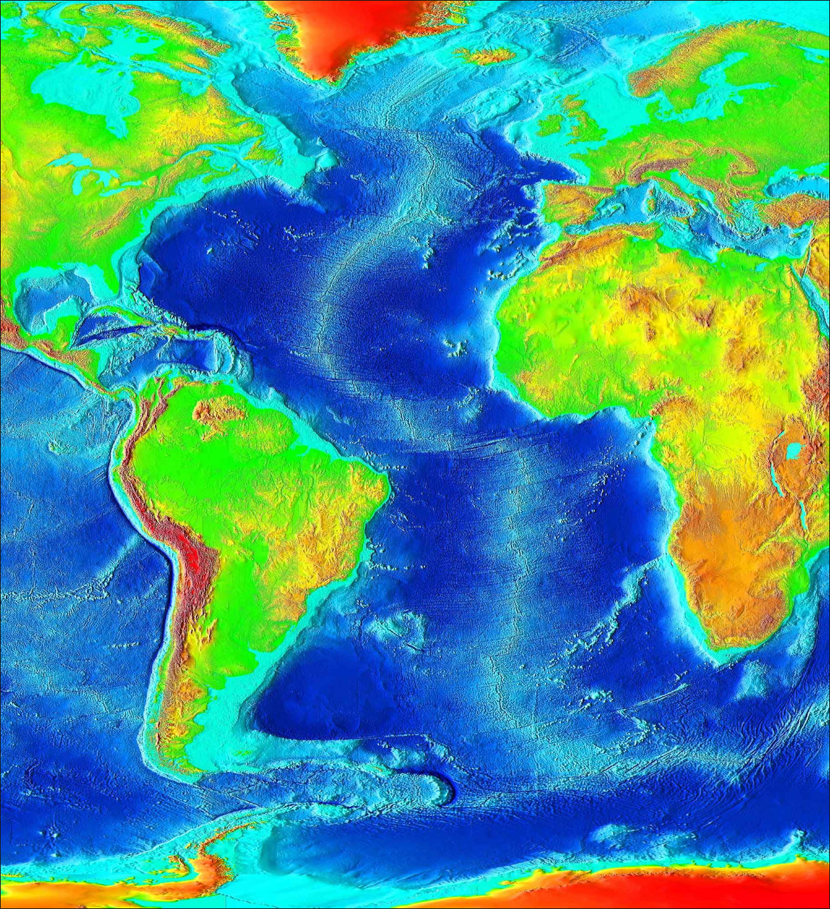
The Atlantic Ocean is the world’s second largest ocean. Covering an area of approximately 106,460,000 square kilometers (41,105,000 square miles), it borders the east coast of the Americas and the west coast of Europe and Africa and separate sthe "Old World" of Africa, Europe and Asia from the "New World" of the Americas form European perception of the World. Up north, the Atlantic connects to the Arctic Ocean and to the Southern Ocean to the south. [Source: NOAA]
Covering approximately 20 percent of the Earth’s surface and containing 29 percent of its surface water area, the Atlantic Ocean is larger than the Indian Ocean but is only slightly larger than half the size of the Pacific Ocean. From the Atlantic Ocean, the Pacific Ocean can be reached through the Straights of Magellan at the tip of South America. The Indian Ocean can be reached from the Atlantic by rounding the Cape of Good Hope at the southern tip of Africa.
Scientists often divide the Atlantic into two basins: the North Atlantic and the South Atlantic. The North Atlantic, where waters sink after being chilled by arctic temperatures, is the start of the “global ocean conveyor,” a circulation pattern that helps regulate Earth’s climate.
The Atlantic Ocean derives its name from the Greek god, Atlas. Atlantic means "Sea of Darkness" in Arabic. The 12th-century Arab geographer Al-Idrisi wrote: "No one knows what is in that sea, because of many obstacles to navigation — profound darkness, high waves, frequent storms, innumerable monsters which people it, and violent winds. No sailor dares to penetrate it; they limit themselves to sailing along the coast without losing sight of land." [Source: "Search for Columbus" by Eugene Lyon, January 1992]
Atlantic bathymetry
The Atlantic Ocean occupies an elongated, S-shaped basin extending longitudinally between Europe and Africa to the east, and North and South America to the west. The Atlantic has irregular coasts indented by numerous bays, gulfs and seas. These include the Baltic Sea, Black Sea, Caribbean Sea, Gulf of Mexico, Labrador Sea, Mediterranean Sea, North Sea and Norwegian Sea.The 16,000-kilometer-long (10,000-mile-long) Mid-Atlantic Ridge (MAR) divides the Atlantic longitudinally into two halves. The longest mountain range in the world, the MAR rises two to three kilometers (1.2–1.9 miles) above the surrounding ocean floor. It s rift valley is the divergent boundary between the North American and Eurasian tectonic plates in the North Atlantic and the South American and African plates in the South Atlantic. The MAR produces basaltic volcanoes such as Eyjafjallajökull, Iceland, and produces pillow lava on the ocean floor. [Source: Wikipedia]
Scientists Figured Out Why the Atlantic Ocean Is Getting Wider
The Atlantic Ocean is widening by about four centimeters (1.5 inches) per year, as the tectonic plates beneath the Americas slowly move away from those under Europe and Africa. For a long time, scientists couldn’t explain this movement, since the Atlantic lacks the dense, sinking plates that help drive plate motion in places like the Pacific. [Source: Aylin Woodward, Jenny McGrath, Business Insider, August 25, 2023]
A 2021 study solved the mystery: The Mid-Atlantic Ridge (MAR) — the long underwater mountain chain in the center of the ocean — sits above an unexpected upwelling of unusually hot material from deep in the mantle, about 660 kilometers (410 miles) beneath Earth’s surface. This rising plume pushes upward on the crust, forcing the plates on either side of the ridge apart.
Normally, deep mantle material can’t reach mid-ocean ridges because of a dense layer called the mantle transition zone, but the study found this zone is hotter and thinner beneath the MAR, allowing material from the lower mantle to rise all the way to the seafloor.
This discovery explains how the Atlantic is spreading despite lacking strong subduction zones: deep mantle upwelling, rather than gravity-driven plate sinking, is powering the ocean’s expansion. The process began roughly 200 million years ago, and while the widening rate is stable today, it may change over millions of years.
Do Waters of the Pacific Ocean and the Atlantic Ocean Mix?
Do the Pacific Ocean and the Atlantic Ocean mix? Yes they do. According to Live Science; They mix constantly — but at different speeds depending on location and conditions. Oceanographer Nadín Ramírez said photographs that show boundaries aren’t hard barriers; they’re temporary contrasts in temperature, salinity or clarity, much like cream slowly swirling into coffee. Wind, storms and waves “stir” the oceans, speeding up mixing. [Source: Meg Duff, Live Science, July 2, 2023]
At the southern tip of South America, differences between the two oceans can briefly appear in places like the Strait of Magellan or Beagle Channel, where freshwater from glaciers or lower-salinity Pacific water meets saltier Atlantic water. But these lines fade as winds and waves blend them. The Drake Passage, between South America and Antarctica, mixes even faster because of its famously rough seas. Mixing also happens in the deep ocean: tides drag water across rugged seafloor, creating turbulence.
Still, not all waters mix completely. The ocean is layered like a “water cake,” with each layer (a cline) carrying properties from its source and mixing more slowly in the mid-ocean depths. Currents can exchange huge volumes of water between oceans without fully transforming their properties.
Global circulation continually moves water from the Pacific into the Atlantic through the Drake Passage, and another system brings water from the Pacific through the Indian Ocean toward Africa and into the Atlantic as well. Climate change is now slowing both mixing and exchange. As polar waters warm and freshen from melting ice, they sink less readily, weakening deep currents. Stronger differences between layers also slow down mixing. Even so, mixing will never stop entirely: as long as Earth has wind and tides, the oceans will keep blending.
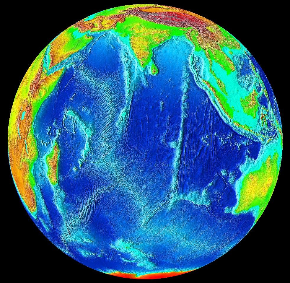
Indian Ocean
The Indian Ocean is the third-largest of the world's five oceanic divisions. Covering 70,560,000 square kilometers (27,240,000 square miles) and accounts for 19.8 percent of the water on Earth's surface, it is bordered by Africa to the west, Asia to the north, Australia to the east and the Southern Ocean or Antarctica to the south. Large marginal seas that branch off the Indian Ocean include the Red Sea, Arabian Sea, the Persian Gulf, Bay of Bengal, and Andaman Sea. [Source: Wikipedia]
The Indian Ocean has been known by its present name since at least 1515. It was named after India, which projects into it. It was earlier known as the Eastern Ocean when it was navigated primarily by people form east Africa and the Middle East. Chinese explorers in the 15th century called it the Western Oceans. The Indian Ocean region was known to the ancient Greeks a the Erythraean Sea.
The ocean-floor of the Indian Ocean is divided by spreading ridges and crisscrossed by aseismic structures The borders of the Indian Ocean used to extends to Antarctica but in 2000 the International Hydrographic Organization recognized the Southern Ocean separately and removed waters south of 60°S from the Indian Ocean. The northernmost extent of the Indian Ocean is approximately 30° north in the Persian Gulf.
The Indian Ocean has an average depth of 3,741 meters (12,274 feet) and a maximum depth of 7,906 meters (25,938 feet) in the Java Trench off Indonesia. All of the Indian Ocean is in the Eastern Hemisphere and the centre of the Eastern Hemisphere, the 90th meridian east, passes through the Ninety East Ridge. In contrast to the Atlantic and Pacific, the Indian Ocean is enclosed by major landmasses and an archipelago on three sides and does not stretch from pole to pole. Centered on the Indian Peninsula and surounded by South and Southeast Asia, Western Asia, Northeast, East and Southern Africa and Australia, it has a maximum length of 9,600 kilometers (6,000 miles) (Antarctica to Bay of Bengal) and a maximum width of 7,600 kilometers (4,700 miles) (Africa to Australia). Its shore length is 66,526 kilometers (41,337 miles).
Indian Ocean
Million-Square-Mile Gravity Hole in the Indian Ocean
In the Indian Ocean there is geoid low — 2.6 thousands square-kilometer (million-square-mile) region where Earth’s gravity is unusually weak and sea level sits 91.5 to 107 meters (300 to 350 feet lower than surrounding waters. In the early 2020s, scientists finally pieced together the most convincing explanation for why this has occured. [Source: Marianne Guenot, Business Insider, July 7, 2023; Victor Tangermann, Futurism, July 1, 2023]
The anomaly likely took shape around 20 million years ago. It’s one of the strongest gravity lows on Earth and offers a rare look into deep-Earth dynamics and the long-term recycling of ancient seafloors. For decades, researchers assumed something directly beneath the anomaly must be causing the dip. But new computer models from the Indian Institute of Science suggest the real cause lies in dynamic processes around it, not underneath it.
About 120 million years ago, the breakup of the supercontinent Gondwana and the northward drift of India tore apart the ancient Tethys Ocean. As India collided with Eurasia, much of the Tethys seafloor sank deep into the mantle beneath Eastern Africa. that dense, ancient seafloor slowly melted, it produced plumes of hot, low-density magma. These buoyant plumes rose beneath the Indian Ocean, creating a vast region where the mantle is lighter than normal — effectively pulling the geoid downward and reducing local gravity. Surrounding high-density areas, such as the rising Tibetan Plateau, also amplify the contrast.
The Indian Ocean’s “gravity hole” is a lingering fingerprint of Earth’s ancient tectonic drama — the breakup of continents, the destruction of an ocean, and the rise of mantle plumes that continue to shape the planet from far below. Scientists still need direct evidence. Future ocean surveys will test whether the predicted magma plumes truly exist. Simulations align with geological history, but nature is more complex than any model.
Arctic Ocean
The Arctic Ocean (also known as the Northern Ocean) is located in the Northern Hemisphere and mostly in the Arctic north polar region. the smallest and shallowest of the world's five major oceanic divisions, it is recognized by the International Hydrographic Organization (IHO) as an ocean, although some oceanographers regard it as an estuary of the Atlantic Ocean or a water body like the Mediterranean Sea. The salinity of the Arctic Ocean is the lowest on average of the five major oceans, due to low evaporation, heavy fresh water inflow from rivers and streams, and limited connection and outflow to surrounding oceanic waters with higher salinities. [Source: Wikipedia]
The Arctic Ocean is the smallest of the world's five ocean basins. With an area of about 15.8 million square kilometers (6.1 million square miles), the Arctic Ocean is about 1.5 times as big as the United States. It is bordered by Greenland, Canada, Norway, Alaska, and Russia. The average depth of the Arctic Ocean is 1,205 meters (3,953 feet) and it is 5,567 meters (18,264 feet) deep at its deepest point. [Source: NOAA]
In some places in the Arctic Ocean the water is highly stratified with relatively fresh water supplied by river water on top and more saline water in the lower depths. In some basins the water has remained undisturbed and isolated for more than 500 years. Rivers supply about a third of the fresh water that enters the Arctic Ocean. Scientist can track down the source of these water by the unique chemical signature of the water. The movements of ice, surface water and near surface water are driven by the clockwise Beaufort Gyre. Below this is a contraclockwise current that moves water primarily of Atlantic origin to the east along the continental margin.
Almost completely surrounded by Eurasia and North America, the Arctic Ocean is partly covered by sea ice throughout the year (and almost completely in the winter). The Arctic Ocean's surface temperature and salinity vary seasonally as the ice cover melts and freezes. The summer shrinking of the ice has been quoted at 50 percent. The US National Snow and Ice Data Center (NSIDC) uses satellite data to provide a daily record of Arctic sea ice cover and the rate of melting compared to an average period and specific past years. [Source: Wikipedia]
The Arctic Ocean’s average temperature seldom rises above freezing. However, this ocean is anything but barren. Tunnels within sea ice called brine channels house bacteria and algae that feed flatworms and other tunnel-dwelling creatures. Melting ice also forms ponds on top of the ice that develop into biological communities. When the ice melts, organisms and nutrients are released into the water. This promotes algae growth below the ice. These algae provide food for small organisms called zooplankton, which are a food source for fish, squid, seals, and whales. Some of these larger creatures, in turn, are preyed upon by polar bears that live on the ice.
When the creatures below the ice die, they sink to the bottom of the ocean and provide nutrients for sponges, sea anemones, and other bottom dwelling creatures. When these communities grow, they provide food once again for larger creatures such as seals, fish, and whales.
Southern Ocean
The Southern Ocean is the 'newest' named ocean. It is recognized by the U.S. Board on Geographic Names as the body of water extending from the coast of Antarctica to the line of latitude at 60 degrees South. The boundaries of this ocean were proposed to the International Hydrographic Organization (IHO) in 2000. However, not all countries agree on the proposed boundaries, so this has yet to be ratified by members of the IHO. The U.S. is a member of the IHO. [Source: NOAA]
Also known as the Antarctic Ocean, the Southern Ocean is comprised the southernmost waters of the world ocean, generally taken to be south of 60° S latitude and encircling Antarctica. Covering of 20,327,000 square kilometers (7,848,000 squar miles), it is considered the second-smallest of the five principal oceans — smaller than the Pacific, Atlantic, and Indian oceans but larger than the Arctic Ocean. Since the 1980s, the Southern Ocean has been subject to rapid climate change, which has led to changes in the marine ecosystem. [Source: Wikipedia]
Sarah Gibbens wrote in National Geographic: Those familiar with the Southern Ocean know it’s unlike any other. “Anyone who has been there will struggle to explain what's so mesmerizing about it, but they'll all agree that the glaciers are bluer, the air colder, the mountains more intimidating, and the landscapes more captivating than anywhere else you can go,” says Seth Sykora-Bodie, a marine scientist at the National Oceanic and Atmospheric Administration (NOAA) and a National Geographic Explorer. [Source: Sarah Gibbens, National Geographic, June 8, 2021]
“The Southern Ocean has long been recognized by scientists, but because there was never agreement internationally, we never officially recognized it,” National Geographic Society Geographer Alex Tait said. Geographers debated whether the waters around Antarctica had enough unique characteristics to deserve their own name, or whether they were simply cold, southern extensions of the Pacific, Atlantic, and Indian Oceans. “It’s sort of geographic nerdiness in some ways,” Tait said.
Southern Ocean: Defined by its Current?
Sarah Gibbens wrote in National Geographic: While the other oceans are defined by the continents that fence them in, the Southern Ocean is defined by a current. Scientists estimate that the Antarctic Circumpolar Current (ACC) was established roughly 34 million years ago, when Antarctica separated from South America. That allowed for the unimpeded flow of water around the bottom of the Earth. [Source: Sarah Gibbens, National Geographic, June 8, 2021]

click the image once and click it again in Wikicommons
“The ACC flows from west to east around Antarctica, in a broad fluctuating band roughly centered around a latitude of 60 degrees south—the line that is now defined as the northern boundary of the Southern Ocean. Inside the ACC, the waters are colder and slightly less salty than ocean waters to the north.
“Extending from the surface to the ocean floor, the ACC transports more water than any other ocean current. It pulls in waters from the Atlantic, Pacific, and Indian Oceans, helping drive a global circulation system known as the conveyor belt, which transports heat around the planet. Cold, dense water that sinks to the ocean floor off Antarctica also helps store carbon in the deep ocean. In both those ways, the Southern Ocean has a crucial impact on Earth’s climate.
“Scientists are currently studying how human-driven climate change is altering the Southern Ocean. Ocean water moving through the ACC is warming, scientists have learned, but it’s unclear how much this is impacting Antarctica. Some of the most rapid melting of the continents ice sheets and shelves have been where the ACC is closest to land.”
Image Sources: Wikimedia Commons; YouTube, NOAA
Text Sources: National Oceanic and Atmospheric Administration (NOAA) noaa.gov; “Introduction to Physical Oceanography” by Robert Stewart , Texas A&M University, 2008 uv.es/hegigui/Kasper ; Wikipedia, National Geographic, Live Science, BBC, Smithsonian, New York Times, Washington Post, Los Angeles Times, The New Yorker, Reuters, Associated Press, Lonely Planet Guides and various books and other publications.
Last Updated November 2025